
|
|
Mountain/Rock |
|---|---|
|
|
40.79640°N / 106.6769°W |
|
|
Routt |
|
|
Hiking, Mountaineering, Trad Climbing, Scrambling |
|
|
Summer, Fall |
|
|
11164 ft / 3403 m |
|
|
Overview
If you like solitude and spectacular views, chances are you will like the Mount Zirkel Wilderness, located in the northern Park Range and Sierra Madre of Colorado. Only a few of the peaks get much attention (namely Mount Zirkel, Mount Ethel, Lost Ranger Peak, and Big Agnes), but even then the popular peaks are much less crowded than many of the other places in Colorado. The Central Peak of the Front Range, featured on this page is not climb very often.Although the peaks in the Mount Zirkel Wilderness are lower than they are in some other parts of Colorado, the Mount Zirkel Wilderness receives more snow on average than any other part of Colorado (nearly 500 inches of snow a year according to SNOTEL data), thus lower mountains have a much more alpine appearance than they would for similar elevation mountains in other parts of Colorado.
The Front Range (not to be confused with the much longer, larger, and well known Front Range also in Colorado) is the name of a ridge between Gilpin Creek and Gold Creek. There are only two ranked summits along this ridge, so I don’t know why this ridge has the nomenclature of a range.
The Central Peak of the Front Range is Peak 11,164 (23rd highest ranked summit in the Park Range) and is featured on this page. The mountain may sound small by Colorado standards, but it is rather rugged and scenic and the snowfields in the northeast cirque usually last year round.
The peak is somewhat of an anomaly as well. It is very often photographed since it forms the background to Gilpin Lake, one of the most popular destinations in the entire Mount Zirkel Wilderness. On the other hand, the peak is seldom climbed. We found that there was only one other signature in the register in the past 15 years.
Park Range: 11,000+ Foot Peaks with 300+ feet of Prominence
 The Central Peak of the Front Range and Gilpin Lake.
Getting There
Slavonia TrailheadFrom Steamboat Springs head two miles NW on US 40 to CR 129 (Elk River Road) and turn right at the stoplight. Head about eighteen miles north, past Clark, to Glen Eden, and turn right again at Seedhouse Road ( AKA CR 64 and FR 400) and follow the road and signs ten miles to the trailhead. Seedhouse Road is passable for passenger cars to the trailhead.
 Gold Creek not far from the trailhead.
Routes Overview
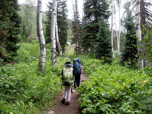
ApproachThe recommended approach route is a loop hike up Gilpin Creek and down Gold Creek. This is a very scenic route and passes by Gilpin Lake and Gold Creek Lake. Most people seem to hike it in the other direction, but I'd recommend going down Gold Creek, if only because you might get your feet wet at the end of the hike rather than at the beginning.
 Gilpin Lake as seen from the pass to the south of the lake.
East Ridge
The East Ridge is probably the most common ascent route and is accessed from the saddle south of Gilpin Lake. Doing the ridge directly requires technical climbing. You can bypass the ridge crest on the south (Class 2+) or north (Class 3) before making the final assault up the peak.
This route is about 12 miles round trip and with about 2800 feet elevation gain.
 East Ridge of Central Peak.
Red Tape
No permits are required. Standard wilderness regulations apply.Additional Regulations:
Camping is prohibited within 100 feet of any trail, wilderness lake or stream. Camping is prohibited within 1/4 mile (1320 feet) of Gilpin Lake, Gold Creek Lake and Three Island Lake. Camping, leaving camping equipment or personal property or otherwise occupying national forest system lands for a period longer than 14 days within a 30-day period on a ranger district is prohibited. Camping within 200 feet of a posted sign reserving a site for a commercial outfitter is prohibited.
Storing equipment, personal property or supplies is prohibited within the wilderness for more than 14 days within a 30-day period, including time the area was used for camping.
Building, maintaining, attending or using campfires is prohibited within 100 feet of any trail, wilderness lake or stream. Building, maintaining, attending or using campfires is prohibited within 1/4 mile (1320 feet) of Gilpin Lake, Gold Creek Lake and Three Island Lake.
Dogs must be leashed or under control.
Possessing, discharging or using any kind of firework or pyrotechnic device is prohibited.
The maximum group size is a combination of 25 persons and/or pack/saddle animals, with the maximum number of persons being 15.
Shortcutting switchbacks is prohibited.
 Don't cut the switchbacks!
When to Climb
August and early September is the most popular time to climb here. July is fine too, but this area gets more snowfall than anywhere else in Colorado, so winter snows tend to stay late and through most of July. Stream crossings along some routes can can be very problematic in June and July.Be aware that if you do climb in July, be aware that the area has one of the biggest mosquito populations in Colorado. My first attempt on the peak was a failure due to mosquitoes. By August, the mosquitoes taper down in most years.
Camping
There are several developed campgrounds along Seedhouse Road for those making the standard approach.Gold Creek, Slovenia Basin and Gilpin Creek all have good campsites, but camping is not allowed within 1/4 of a mile of Gold Creek Lake and Gilpin Lakes.
 The Sawtooth Range and Mount Zirkel (right) as seen from near the summit of Central Peak of the Front Range as seen in late July.
Mountain Conditions
For current information, contact:HahnsPeak/Bears Ears Ranger District
925 Weiss Drive
Steamboat Springs, CO 80487-9315
970-879-1870
FAX 970-870-2284
CLICK HERE FOR THE WEATHER FORECAST FOR MOUNT ZIRKEL WILDERNESS
Below is the National Weather Service Climate Summary of Steamboat Springs. The data is from 1908-2012. This is the closest long term weather station, but be aware that higher elevations will be much wetter and colder. Steamboat Springs is at 6695 feet elevation, so expect the temperatures on Central Peak to be 15-20 degrees colder than in Steamboat (except for cold winter nights).
| MONTH | AVE HIGH | AVE LOW | REC HIGH | REC LOW | AVE PREC (in) |
| JAN | 29 | 1 | 57 | -54 | 2.47 |
| FEB | 34 | 4 | 59 | -48 | 2.24 |
| MAR | 42 | 13 | 70 | -34 | 2.11 |
| APR | 54 | 24 | 79 | -15 | 2.28 |
| MAY | 65 | 31 | 88 | 8 | 2.08 |
| JUN | 75 | 36 | 96 | 19 | 1.49 |
| JUL | 82 | 41 | 97 | 25 | 1.54 |
| AUG | 80 | 40 | 98 | 20 | 1.60 |
| SEP | 72 | 33 | 93 | 6 | 1.81 |
| OCT | 60 | 24 | 89 | -16 | 1.89 |
| NOV | 43 | 14 | 72 | -28 | 1.97 |
| DEC | 31 | 3 | 64 | -44 | 2.38 |