
|
|
Mountain/Rock |
|---|---|
|
|
40.48974°N / 106.82159°W |
|
|
Routt |
|
|
Trad Climbing, Toprope |
|
|
Spring, Summer, Fall |
|
|
6800 ft / 2073 m |
|
|
Overview
The Butcher Knife Crags are located right in Steamboat Springs Colorado. The climbs are all short, mostly in the 25-40 foot high category, but the rock is good and the climbs are surprisingly fun.Although the climbs are located in the town, they are in a beautiful nature part, so it doesn't really seem like you are in the town while climbing them.
Sport climbing would probably be frowned upon here, since the anchors would be visible to other park users, but there are plenty of top rope climbs and some climbs that can be lead on gear.
The Butcher Knife Crags consist of three main crags known as Butcher Knife, Grey Face, and East Butcher Knife. Route difficulty on the crags ranges from 5.7 to 5.11b.
If you are in Steamboat Springs and don't have time to head out to the more distant crags, than this is a good place to climb.
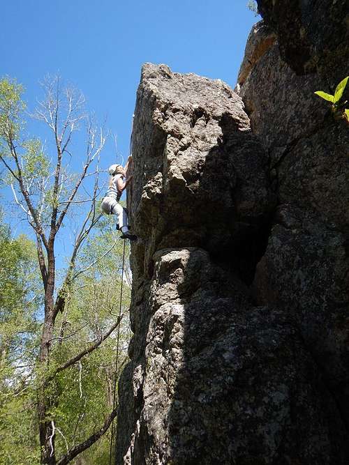 Shaylee on North Face, East Butcher Knife.
Getting There
DrivingAccess is very easy. From Highway 40/Lincoln Avenue in Steamboat Springs, turn northeast onto 7th Street. Follow 7th Street until it turns right into Missouri Avenue.
Follow Missouri Avenue East until it makes a sharp left at Stehley Park. Park here as the Butcher Knife Crags are located in the park.
 The sign at the trailhead. The trail is maintained by the nearby hospital. If you get hurt climbing, at least you will be near the hospital!
 Approach
Enter the park and take the footpath east and across the bridge. Continue on the footpath. You will pass a small outcrop on the right before reaching the main crags. Continue along the main path to the crags.
Butcher Knife is the first crag you reach on the left.
Grey Face is the first Crag you reach on the right.
East Butcher Knife (I don't know if this has another name) is the second crag you reach on the right.
All of these crags are only a few minutes from the trailhead.
Routes Overview
Routes are listed left to right.Butcher Knife
| ROUTE | DIFFICULTY | GEAR | QUALITY |
| Left Hook | 5.10b | TR | Good |
| Butcher Knife Crack | 5.9 | TR or medium nut, 1 #2 Camalots, and 1 #0.5 Camelot | Good |
| Right of Crack | 5.11d | TR | Good |
| Bear Hut | 5.9 | TR | Good |
| The Mantles | 5.10 | TR | Fair |
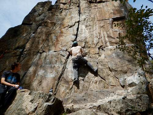 Me climbing Butcher Knife.
Grey Face
| ROUTE | DIFFICULTY | GEAR | QUALITY |
| Grey Face Left (The Cave) | 5.10d | TR, but exposed to get to anchor. Use long runner. | Good |
| Grey Face Middle | 5.8 | TR | Good |
| Grey Face Right | 5.9 | TR | Fair |
 Kessler climbing Grey Face.
East Butcher Knife
| ROUTE | DIFFICULTY | GEAR | QUALITY |
| North Face | 5.7+ | TR, slightly exposed to set anchor | Good |
| Dihedral | 5.1 PG13 | None-can be used to set anchor | Fair |
 Kimberly climbing East Butcher Knife.
Red Tape
Sport routes are probably not a good idea since the climbs are in a park and since they anchors will be too visible.There is no real red tape, but tread very lightly and carefully here as any damage to the area will result in the closure of climbing in the park.
When to Climb
The climbs do get shade in the mornings and evenings, depending on exposure so summer climbing is possible.If going in Spring, wait until the area dries out as you don't want to be tromping around in the mud, which will damage the area. By early May, things should be fairly dry except after rain and snow storms.
Fall is an excellent time to climb here.
 Descending after climbing East Butcher Knife on the last day of May 2017.
Camping
There are many campgrounds in Routt National Forest in the vicinity of Steamboat Springs, but none in the immediate vicinity.Steamboat Springs has a KOA as well:
Steamboat Springs KOA
Mountain Conditions
CLICK HERE FOR THE WEATHER FORECASTBelow is the National Weather Service Climate Summary of Steamboat Springs. The data is from 1908-2016. The climbs are located in Steamboat Springs.
| MONTH | AVE HIGH | AVE LOW | REC HIGH | REC LOW | AVE PREC (in) |
| JAN | 29 | 1 | 57 | -54 | 2.47 |
| FEB | 34 | 4 | 59 | -48 | 2.24 |
| MAR | 42 | 13 | 70 | -34 | 2.11 |
| APR | 54 | 24 | 79 | -15 | 2.28 |
| MAY | 65 | 31 | 88 | 8 | 2.08 |
| JUN | 75 | 36 | 96 | 19 | 1.49 |
| JUL | 82 | 41 | 97 | 25 | 1.54 |
| AUG | 80 | 40 | 98 | 20 | 1.60 |
| SEP | 72 | 33 | 93 | 6 | 1.81 |
| OCT | 60 | 24 | 89 | -16 | 1.89 |
| NOV | 43 | 14 | 72 | -28 | 1.97 |
| DEC | 31 | 3 | 64 | -44 | 2.38 |