
|
|
Mountain/Rock |
|---|---|
|
|
40.69050°N / 106.6724°W |
|
|
Routt/Jackson |
|
|
Hiking, Mountaineering |
|
|
Summer, Fall |
|
|
11934 ft / 3637 m |
|
|
Overview
Lost Ranger Peak is a beautiful peak in the heart of the Mount Zirkel Wilderness Area. It is one of the more isolated peaks in the state of Colorado, yet it is easy to climb and has a trail to very near the summit. In contrast to some of the other peaks in the area, especially just to the north, Lost Ranger is a gentle peak. It is also the 4th highest peak in the Park Range.Since the peak has a lot of area above timberline, it is ravaged by storms. According to the Forest Service, the Buffalo Pass and Mad Creek drainage areas are the snowiest places in Colorado, beating out their rival, Wolf Creek Pass in the San Juan Mountains, by a healthy margin. Because of the heavy snowfall, many rather large snowfields on the peak last year round, despite the peak’s somewhat low elevation by Colorado standards. The area stays green for much longer in the season than many other mountain areas in Colorado. Since the peak is surrounded by alpine tundra, it can be tricky to descend to a safe altitude when storms do blow up.
Since the peak is right near the Wyoming Trail/Continental Divide Trail, it sees a fair amount of ascents, but it’s still amazing how many people hike the trail and not make the short few hundred feet to the summit.
Park Range: 11,000+ Foot Peaks with 300+ feet of Prominence
So, how did Lost Ranger Peak get its name? Lost Ranger Peak sits on the boundary of two ranger districts in the Routt National Forest. The story goes that a ranger from one district got lost on the mountain, and had to be rescued by the rangers in an adjoining district.
Of course the rangers in the Hahn Peak/Bears Ears District, on the west side of the Park Range, claim that the ranger that got lost was from the Park District and the Hahns Peak/Bears Ears District came to the rescue. Quite naturally, if you talk to the rangers on the east side of the Park Range (Park District), they tell the same story, only that it was the Hahns Peak/Bears Ears ranger who got lost and the rangers from the Park District are the ones who came to the rescue!
 The south side of Lost Ranger Peak as seen from Mount Ethel.
Getting There
Lost Ranger Peak sits in the heart of the Mount Zirkel Wilderness and thus can be approached from any direction. Here are the main trailheads.Buffalo Pass
Buffalo Pass can be reached from the Walden area on the east and the Steamboat Srings area on the west. I am familiar only with the western approach. Be aware that the road over the pass isn’t usually open until mid July and sometimes later. Even in dry years the pass is usually still closed in early July.
From Steamboat Springs and on the main drag (Lincoln Avenue/Highway 40), turn north on 3rd Street. Drive one block and turn right onto Amethyst. After 1.6 miles, the road joins Highway 323. Stay right and drive 2.4 miles before turning right onto CR 38, which is signed for Buffalo Pass.
Drive 13 miles up the sometimes rough road to the pass. Most passenger cars can make it when dry. Park in the parking lot on the south side of the road signed for Trail 1101.
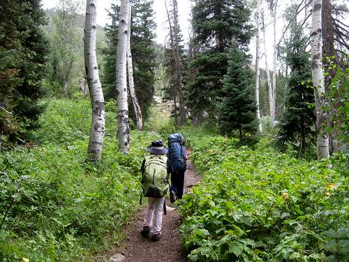
 Hiking along the trail near the Buffalo Pass Trailhead.
Rainbow Lakes Trailhead
From Walden, drive Highway 14 west for about 0.6 miles. Turn right onto CR 12W and follow it for about five miles. Keep left. The road becomes CR 18 which is driven for about 4.5 miles to an intersection. Turn left onto CR 5. The pavement ends here.
Follow CR 5 for 1.8 miles and keep straight on CR 22. Keep right at an unmarked junction. Drive to the end of the road and park. The last part of the road is rough, but is passable to most vehicles when dry.
Red Canyon Trailhead
From Walden, drive Highway 14 west for about 0.6 miles. Turn right onto CR 12W and follow it for about five miles. Keep left. The road becomes CR 18 which is driven for about 4.5 miles to an intersection. Turn right onto CR 5. At Delany Lakes, turn left onto CR 20. Drive CR 20 west for 4.2 miles and turn right onto FR 652 which is a 4wd road. The trailhead is at the end of this 3 mile long road.
Lake Katherine Trailhead
From Walden, drive Highway 14 west for about 0.6 miles. Turn right onto CR 12W and follow it for about five miles. After about 10 miles of following CR 12, turn left on CR 16. Follow this road to its end. At the forest boundary, the road becomes FR 640.
Slavonia Trailhead
From Steamboat Springs head two miles NW on US 40 to CR 129 (Elk River Road) and turn right at the stoplight. Head about eighteen miles north, past Clark, to Glen Eden, and turn right again at Seedhouse Road (A.K.A. CR 64 and FR 400) and follow the road and signs ten miles to the trailhead. Seedhouse Road is passable for passenger cars to the trailhead.
 Gold Creek not far from the trailhead.
Three Island Lake Trailhead
From Steamboat Springs head two miles NW on US 40 to CR 129 (Elk River Road) and turn right at the stoplight. Head about eighteen miles north, past Clark, to Glen Eden, and turn right again at Seedhouse Road (A.K.A. CR 64 and FR 400) and turn right. Drive about 9 miles until approximately 0.7 miles past the Seedhouse Campground. Turn right onto FS 443 and drive for 3.2 miles to the second signed trailhead for Three Island Lake.
North Lake Trailhead
The trailhead is 1.4 miles past the Three Island Lake Trailhead (see above).
Routes Overview
As mentioned, Lost Ranger Peak sits in the heart of the Mount Zirkel Wilderness and thus can be approached from many directions. The peak is gentle and is easy via any of the routes described, but by Colorado standards, the routes are fairly long.All routes use eventually converge at various places along the Continental Divide/Wyoming Trail which passes just to the east of the summit. The summit is a short off trail hike from the highest point of the trail
The main routes are highlighted below.
Via Buffalo Pass
This is the longest of the routes described, but because the trailhead elevation is high, it is perhaps the easiest route on Lost Ranger Peak. The road to the trailhead usually doesn’t open until sometime in July.
This route follows the Continental Divide/Wyoming Trail north from Buffalo Pass. This is a beautiful route and much of it is above timberline. Since there aren’t many places to descend along much of the trail, this isn’t a good route when you have a bad weather forecast.
The route follows the rolling Continental Divide from the trailhead and is 25.4 miles round trip. While a strong hiker and climber could do this route in very long day, assuming the weather is good, at least two days are recommended. There are many side hikes to various peaks and lakes, so it’s easy to spend several days along the route.
 The Continental Divide just south of Lost Ranger Peak.
Via Rainbow Lakes Trailhead
This route on the east side of the Park Range climbs a ridge along a trail which descends into a pretty basin containing the Rainbow Lakes. From there the trail climbs past the Slide Lake and then to the Continental Divide/Wyoming Trail about 1.6 miles south of the summit of Lost Ranger Peak.
This route is 20.8 miles round trip and is usually considered a two day hike.
 Lost Ranger Peak as seen from near the Rainbow Lakes/Continental Divide Junction.
Via Red Canyon Trailhead
This is the shortest route to Lost Ranger Peak and is also on the east side of the Park Range. The route follows the trail through the rugged and impressive Red Canyon before climbing above the canyon and meeting the Continental Divide/Wyoming Trail about 1.6 miles north of Lost Ranger Peak.
This route is 15.0 miles round trip and can be done in one long day. It can also be done as an overnighter.
Via Lake Katherine Trailhead
This trail is on the east side of the Park Range and follows the Lone Pine Trail up to the Continental Divide/Wyoming Trail about 5.5 miles north of Lost Ranger Peak. There are many good campsites along the trail below timberline. This route is 19.2 miles round trip and is generally considered to be a two day hike.
Via Slavonia Trailhead
This popular trail is on the west side of the Park Range. The route follows the trail to Gold Creek Lake and then to the Continental Divide/Wyoming Trail and then south along the long ridge for 7.7 miles to Lost Ranger Peak. The biggest obstacles are two river crossings which can be very problematic until early August.
This route is 22.2 miles round trip and is generally considered to be a two-day climb.
Via Three Island Lake Trailhead
This route is on the West Side of the Park Range and accesses the Continental Divide/Wyoming Trail from the Three Island Lake Trail. The trail is fairly steep in places, but there are no problems. One on the Continental Divide/Wyoming Trail, you follow it south 3.6 miles to Lost Ranger Peak
This route is 19.8 miles round trip and is generally considered to be a two day climb.
Via North Lake Trailhead
This is the second shortest route to Lost Ranger Peak and is the shortest route from the west side of the Park Range. The trail is less used that the previous two routes mentioned. This route follows the North Lake Trail to North Lake and then meets the Continental Divide/Wyoming Trail not far beyond. The first part of the trail is steep, but it becomes gentler after the initial climb. From the junction of the Wyoming Trail, Lost Ranger Peak is 2.8 miles to the south.
This route is 16.6 miles round trip and can be done in one very long day, though an overnight trip would be enjoyable.
Other Routes
The northwest face of Lost Ranger Peak holds some class two routes that can be climbed from the Pristine Lake area. Joseph Kramarsic, in his Park Range book, mentions a snow climb route on the east face of the mountain below teh Wyoming Trail.
Red Tape
No permits are reqired. Standard wilderness regulations apply.Additional Regulations:
Camping is prohibited within 100 feet of any trail, wilderness lake or stream. Camping is prohibited within 1/4 mile (1320 feet) of Gilpin Lake, Gold Creek Lake and Three Island Lake. Camping, leaving camping equipment or personal property or otherwise occupying national forest system lands for a period longer than 14 days within a 30-day period on a ranger district is prohibited. Camping within 200 feet of a posted sign reserving a site for a commercial outfitter is prohibited.
Storing equipment, personal property or supplies is prohibited within the wilderness for more than 14 days within a 30-day period, including time the area was used for camping.
Building, maintaining, attending or using campfires is prohibited within 100 feet of any trail, wilderness lake or stream. Building, maintaining, attending or using campfires is prohibited within 1/4 mile (1320 feet) of Gilpin Lake, Gold Creek Lake and Three Island Lake.
Dogs must be leashed or under control.
Possessing, discharging or using any kind of firework or pyrotechnic device is prohibited.
The maximum group size is a combination of 25 persons and/or pack/saddle animals, with the maximum number of persons being 15.
Shortcutting switchbacks is prohibited.
 In addition to the red tape mentioned above, make sure to take proper bear precautions. We saw this bear track right along the Continental Divide.
When to Climb
August and early September is the most popular time to climb here. July is fine too, but this area gets more snowfall than anywhere else in Colorado, so winter snows tend to stay late and through most of July. Stream crossings along some routes can can be very problematic in June and July.The road to the Buffalo Pass Trailhead isn't even open until Mid-July and sometimes later.
Be aware that if you do climb in July, be aware that the area has one of the biggest mosquito populations in Colorado. My first attempt on the peak was a failure due to mosquitoes. By August, the mosquitoes taper down in most years.
 The snowfields on Lost Ranger Peak usually last year round as this photo taken in mid-August demonstrates. Expect to walk through snowfields, even in late summer.
 Getting hit by snow on August 9 2014 on Lost Ranger Peak. Before this it was hailing and raining.
Fall is a fine season as well, but wear blaze orange during the hunting season. Big snowfalls usually don’t come until late September or early October.
Winter ascents of Lost Ranger Peak are certainly possible, though it’s a long trek in when the roads are closed. Because of heavy snowfall, trail breaking will not be easy, though there are routes with minimal avalanche danger. For the well prepared climber, a winter ascent would prove a worthy challenge.
Camping
Campgrounds and Vehicle CampsitesThere is a campground at Summit Lake right near Buffalo Pass. There are also some informal campsites along the access road.
There are several developed campgrounds along Seedhouse Road for those making the using the Savonia, Three Island Lakes, and North Lakes Trailheads.
There are no campgrounds at or near the three east side trailheads, but there are many informal campsites around each trailhead.
Backcounty Campsites
There are many backcountry campsites in the area, but there are no good campsites around the peak itself because of its exposed nature.
Buffalo Pass Route
If you are using the Buffalo Pass route, Luna Lake would be the most popular campsite in the area, but it can be somewhat congested.
Some really nice and secluded campsites are located six miles in from Buffalo Pass and just east of the saddle south of elevation 10969 on the map. There is a spring here that feeds Newcomb Creek.
 An ideal campsite near the head of Newcomb Creek.
Divide Pond makes an OK campsite.
Rainbow Lakes Route
The Rainbow Lakes area is a popular campsite, but you must camp away from the lake and there is no camping allowed between the trail and the lake. More secluded campsites are located a bit farther up the valley.
Red Canyon Route
Campsites are rather sparse on this route. There are campsites in the bottom of Red Canyon, but it isn't that far from the trailhead. There are also some campsites near where the trail reaches the rim of Red Canyon.
Katherine Trailhead Route
There are many campsites scattered along this route all the way to timberline.
Slavonia Route
Gold Creeks has some good campsites, but camping is not allowed within 1/4 of a mile of Gold Creek Lake.
Three Island Lake Route
Campsites are sparse along the route until you reach Three Island Lake. There are campsites around Three Island Lake as well as some more secluded ones higher up in the basin.
North Lake Route
There are good campsites close to North Lake as well as some higher and lower in the basin. There aren't many campsites until you are about a mile before the lake.
Mountain Conditions
For current information, contact:Hahns Peak/Bears Ears Ranger District
925 Weiss Drive
Steamboat Springs, CO 80487-9315
970-879-1870
FAX 970-870-2284
CLICK HERE FOR THE WEATHER FORECAST FOR THE MOUNT ZIRKEL WILDERNESS
Below is the National Weather Service Climate Summary of Steamboat Springs. The data is from 1908-2012. This is the closest long term weather station, but be aware that higher elevations will be much wetter and colder. Steamboat Springs is at 6695 feet elevation, so expect the temperatures on Lost Ranger Peak to be 15-20 degrees colder than in Steamboat (except for cold winter nights).
| MONTH | AVE HIGH | AVE LOW | REC HIGH | REC LOW | AVE PREC (in) |
| JAN | 29 | 1 | 57 | -54 | 2.47 |
| FEB | 34 | 4 | 59 | -48 | 2.24 |
| MAR | 42 | 13 | 70 | -34 | 2.11 |
| APR | 54 | 24 | 79 | -15 | 2.28 |
| MAY | 65 | 31 | 88 | 8 | 2.08 |
| JUN | 75 | 36 | 96 | 19 | 1.49 |
| JUL | 82 | 41 | 97 | 25 | 1.54 |
| AUG | 80 | 40 | 98 | 20 | 1.60 |
| SEP | 72 | 33 | 93 | 6 | 1.81 |
| OCT | 60 | 24 | 89 | -16 | 1.89 |
| NOV | 43 | 14 | 72 | -28 | 1.97 |
| DEC | 31 | 3 | 64 | -44 | 2.38 |