
-
 10085 Hits
-
 77.48% Score
-
 8 Votes
|
|
Mountain/Rock |
|---|---|
|
|
35.57150°N / 107.154°W |
|
|
Sandoval |
|
|
6858 ft / 2090 m |
|
|
Overview
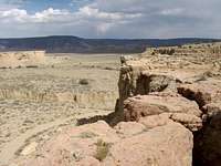
Cerro de Santa Clara is another volcanic relic in the Rio Puerco Valley. It rises like like a buried Aztec Temple next to the slender, shorter Cerro de Guadalupe in the northern portion of the valley between Mesa Prieta and the San Mateo Mountains. The peak is a thin mesa that is not slim enough to be referred to as a butte. Basically a broad mass of hard volcanic rock sitting atop a hill, the peak is surrounded by scree and typical, loose New Mexican dirt, making for a non-technical scramble to the summit. However, the gentler slopes of this peak provide rattlesnakes with prime sites to take up residence and a little caution must be taken. The total elevation gain is anywhere between 850-950 ft., depending on where you begin. Since the taller Cabezon Peak attracts most of the attention, human traffic is close to nil in this area. |  |
Getting There
Drive north on I-25 to Bernalillo from Albuquerque and take exit 242 onto US-550. Travel west through Bernalillo (1 mile), and northwest to San Ysidro (22 miles), and then an additional 19 miles to the turnoff to the villages of San Luis, Cabezon, and Torreon, which are on NM-279. It is a paved road for a couple miles past the village of San Luis and then becomes an equally wide dirt road around 8 miles from US-550. The main road takes a sharp turn to the right at a sign that warns you to slow down to 15 mph; another road you don’t want to take continues straight forward. After half a mile the road forks; stay left and go towards Cabezon Peak. Continue past the turn off to Cabezon and descend into a shallow valley where the road winds along the arroyo at the bottom. Continue straight on the road until you are to the south of the pass between Cerro de Guadalupe and Cerro de Santa Clara. Take a right onto another dirt road towards the south side of Cerro de Santa Clara so you don’t have to bother finding a route across the deep arroyo that travels between the two peaks. Choose a spot to park here on the side of the road and begin.Red Tape
There are no fees or permits for hiking on BLM land.For further information take the link below to the Bureau of Land Management Field Office in Albuquerque.
BLM Link
When To Climb
The peak is climbable at all times during the year. The best periods are between March and May and also between August and November. The summer months can cook the mountain to unbearably hot temperatures and ice thawing in the afternoon during the winter can give way to rockfalls. Due to the dust, dry air, altitude, and intense sun that drain you of water, it is important to pack plenty of it (a couple of liters is good). It's best to leave early in the morning to beat the heat.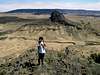 |
Camping
None of the routes up the peak take longer than a few hours and definitely no longer than a day. However, if you do plan to spend the night on the peak or in the vicinity, there are no restrictions to camping on BLM land. It should be pretty easy to find a campsite in the area since the land is basically a bunch of sedimentary rock layers that make for flats piled upon one another.Mountain Conditions
San Ysidro is the closest town to the Cabezon area at around 25 miles to the east.Weather at San Ysidro
The weather for the cities of New Mexico can be seen at the links below.
Weather for New Mexican Cities
Albuquerque and Santa Fe are the closest cities on the list provided by newmexico.org.
Conservation Campaign

“The BLM is directed to preserve the wilderness values of the Cabezon Wilderness Study Area (WSA) for the long term. This involves protecting the area’s special features and natural qualities, including outstanding opportunities for solitude and primitive recreation. Preserving wilderness values is a difficult task that requires a commitment from you as well as the BLM. The challenge for land managers lies in making sure the use of the other resources and activities within the WSA is compatible with its wilderness resource. The challenge for you is to use the area in harmony with the wilderness environment.
You do not need a permit to climb Cabezon Peak. However, permits are required for most uses other than primitive recreation, including mineral exploration, grazing, outfitting/guiding, commercial filming, and scientific research.”
Cabezon Peak Pamphlet by the BLM
This method the BLM uses is insufficient for the protection of these great landmarks in the New Mexican landscape. The door stays open for those who would seek profits at the expense of others’ enjoyment. The desert environment is fragile by nature and takes many years to recover from harsh treatment. Already, heavy grazing by cattle has reduced many portions to near badland-like conditions, which exposes the land to erosion. Another detrimental effect from local ranchers is the use of cyanide on coyotes, which makes its way into the food chain, eventually affecting most fauna including birds of prey. Closed gates on public roads also restrict access to these public lands.
An experiment designed to measure the effects of grazing on vegetation is being planned at the moment and will produce results within the next five years. In the mean time, an effort must be made to create more protections in the Rio Puerco Valley and open up the public lands for more uses than just cattlegrazing.
Some solutions are managing the cattle grazing in a way that would reduce the harmful effects on the vegetation. If the frequency that a certain portion of land is grazed is reduced and rotation of cattle herds through these areas is organized more properly, such effects could be reduced.
Another is making the region a national monument or enveloping the whole valley under the blanket of the wilderness study area. There are many other ways to improve the management of this land. Your ideas and contributions are essential for progress to be made.
Public opinion is a great vehicle to get this moving and the links below are to help with that.
New Mexico Senator Jeff Bingaman
New Mexico Senator Pete Domenici
New Mexico BLM Feedback Page
New Mexico Congressman Tom Udall
New Mexico Congresswoman Heather Wilson
New Mexico Governor Bill Richardson