


-
 4350 Hits
-
 82.48% Score
-
 15 Votes
|
|
Area/Range |
|---|---|
|
|
45.68160°N / 7.60823°E |
|
|
Hiking, Mountaineering, Trad Climbing |
|
|
Spring, Summer, Fall, Winter |
|
|
4288 ft / 1307 m |
|
|
Note
La montagna chiama i suoi figli, ed essi rispondono fedelmente al suo appello… Osvaldo Cardellina, Diario alpinistico, 1964-65 Page texts: @ OsvaldoCardellina "Osva", passed away on May 2, 2022. Page owners: Christian Cardellina e Osvaldo Cardellina. Any updates from September 12, 2022: Antonio Giani, page administrator, friend and climbing companion. Testi della pagina: @ OsvaldoCardellina "Osva", scomparso il 2 maggio 2022. Proprietari pagina: Christian Cardellina e Osvaldo Cardellina. Eventuali aggiornamenti dal 12 settembre 2022: Antonio Giani, amministratore della pagina, amico e compagno di salite. |
Lakes Overview
 |
The Champorcher Valley or how you want to small Valley of the Lakes, perpendicular to the East and to the South towards that of Champorcher and in North towards the central axis of the Valley, is the first coming from the East, or from the Po Valley (Turin and Milan), amongst those aimed at Dora Baltea on the South side of the Valley of Aosta. Considered a vallon, actually is, given the length and size in general, is as a real valley. Along its sides Eastern and Southern borders the Champorcher Valley, while in the West, after the pyramid of Mont Glacier (3.186m), the highest mountain of the whole area, down a watershed that separates the first from the Vallon of Savoney, secondary that Fénis-Clavalité High-Comba Tersiva and, after the Raye Chevrères Hill, from wild Vallon of Ponton, "wedged" between the two. But the mountain that is par excellence is the Mont Avic (3.006m), because at first thing is not to be shared with almost nobody, except the solitary and seeds unknown Walloon of Ponton, while the Glacier should be "shared out" in three parts equal (Champorcher, Champdepraz and Fénis). The second consideration, certainly the most important, is that while the Glacier hidden back there is "invisible" as is concealed from Mount Iverta (2.939m) above the Mines of Lake Gelato (2.599m), the Avic appears already in plain view from the valley floor, passing perhaps with the train at the Town of Verrès. One emblem and an important reference point, a hinge to allow the immediate identification of the Valley or, if you prefer, the small Valley of Champdepraz.
La Valle di Champorcher o come si vuole Vallone dei Laghi, perpendicolare verso Sud a quella di Champorcher ed a Settentrione all'asse centrale della Valle, é la prima venendo da Oriente, cioé dalla Pianura Padana (Torino e Milano), di quelle rivolte alla Dora Baltea sul lato Meridionale della Valle di Aosta. Considerato un vallone, in realtà si configura, vista la lunghezza e le dimensioni in generale, come vera e propria valle. Sui suoi lati Est e Sud confina con la Valle di Champorcher, mentre ad Occidente, dopo la piramide del Mont Glacier (3.186 m), la montagna più elevata dell'intera area, scende uno spartiacque che dapprima la separa dal Vallone di Savoney, secondario a quello di Fénis-Clavalité-Alta Comba Tersiva e, dopo il Colle Raye Chevrères, dal selvaggio Vallone del Ponton, "incastrato" tra i due. Ma la montagna che lo rappresenta per antonomasia é il Mont Avic (3.006 m), perché per prima cosa non dev'esser condiviso con quasi nessuno, tranne il solitario e semisconosciuto Vallone del Ponton, mentre il Glacier deve essere "spartito" in tre parti uguali (Champorcher, Champdepraz e Fénis). La seconda condiderazione, certamente la più importante, é che, mentre il Glacier nascosto là dietro risulta "invisibile" occultato com'é dall'Iverta (2.939 m) sopra le Miniere del Lago Gelato (2.599 m), l'Avic appare in bella vista già dal fondovalle, transitando magari col treno presso il Comune di Verrès. Un'emblema ed un punto di riferimento importante, un cardine tale da permettere l'immediata individuazione della Valle o, se si preferisce, il Vallone di Champdepraz.
 |
 |
 |
 |
 |
- Although this valley has several vallons (see below), we prefer to distinguish it for convenience of description in only three areas:
1) - the vallon that immediately after the pasture of Praz Oursi Department is directed towards the Colle Varotta, sending a branch to the North towards the Mont Barbeston.
2) - the vallon "central" to the same alpine climbs towards the South following the course of the Torrent de Chalamy to reach the Lake Gelato with its Ironmines.
3) - the vallon that reaches from Voella the "Warehouse" and just after Lake of the Serva, below Bec L'Espic. From this point the same expands Eastward to the watershed that comes from the Cima Piana, while another branch proceeds towards Southeast reacching the Refuge Barbustel (2.209m), below the slopes of the two Hills of Lake Bianco (2.308m), de la Croix. The same then flexes with a subsequent branching to the West and, after a series of lakes, reaches the Great Lake (2.485m), the largest in the Aosta Valley at the foot of the Gran Rossa and Mont Glacier. The first two lead in the Valley of Champorcher, while Col Mezove or Medzove (2.613m) at the base of the North Edge of Glacier, brings in the secondary Vallon of Savoney; a third collar 2.800 meters, least important, closes the turn to the North allowing to reach the Lacs des Heures between Mont Iverta L'Invers del Lago Gelato (Opposite by Lake). A short and easy descent back to the underlying lake with the mines and thereby for close the circle back to Voella.
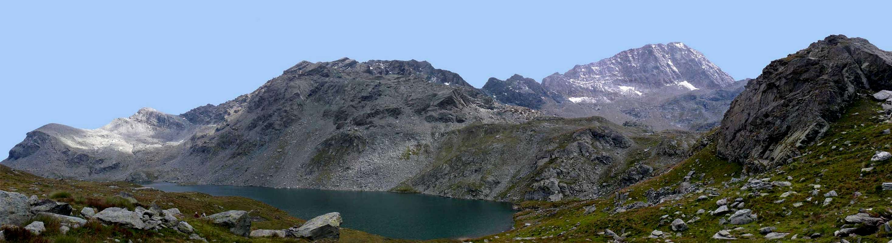
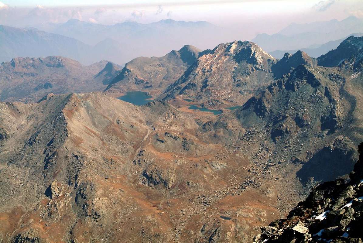
![]()
Champdepraz Vallons with (left) Invers del Lago Gelato, Raye Chevrères Hill, Mont Avic (3.006m), Varotta Pass & Mont Rouvìc by emilius
- Anche se questa valle possiede diversi valloni (vedi sotto) preferiamo distinguerla per comodità di descrizione in tre soli settori:
1) - il vallone che subito dopo l'Alpeggio di Praz Oursì s'indirizza verso il Colle Varotta, inviando un ramo a Settentrione verso il Mont Ruvìc, il Barbeston ed il Mont Lyan.
2) - il vallone "centrale" che dallo stesso alpeggio sale verso Mezzogiorno seguendo il corso del Torrent de Chalamy per raggiungere il Lago Gelato con le sue Miniere di ferro.
3) - il vallone che da Voella raggiunge il "Magazzino" e subito dopo il Lago della Serva, sotto il Bec L'Espic. Da questo punto il medesimo s'allarga ad Oriente verso lo spartiacque proveniente dalla Cima Piana, mentre un altro ramo procede verso Sudest raggiungendo il Rifugio Barbustel (2.209 m), alle pendici dei due Colli del Lago Bianco (2.308 m) e de la Croix. Lo stesso poi flette con una successiva ramificazione ad Ovest e, superata una serie di laghi, raggiunge il Gran Lago (2.485 m), il più grande della Valle d'Aosta alle pendici della Gran Rossa e del Mont Glacier. I primi due conducono nella Valle di Champorcher, mentre il Col Mezove o Medzove (2.613 m), posto alla base dello Spigolo Nord del Glacier, porta nel secondario Vallone di Savoney; un terzo colletto 2.800 metri, meno importante, chiude il giro verso Settentrione permettendo di raggiungere i Lacs des Heures tra il Monte Iverta e L'Invers del Lago Gelato. Una discesa facile e breve riconduce al sottostante Lago Gelato e Miniere chiudendo in questo modo il cerchio nuovamente verso Voella. But this, as well as Lakes, is also the Valley of Mines and of the Natural Park of Monte Avic, Southern margins which reach, after passing the watershed, including the Valley of Champorcher until Torrent Ayasse. The same has been established by the Autonomous Region of the Aosta Valley with Regional Law n°66 of October 19th, 1989 that initially covered only the territory of the upper middle of the Valley of Champdepraz, but with the next (2003) expansion of protected areas, past the Chain of Mont Glacier, come up to Dondena Village. At the same there is traditional for the Valley Fauna and Flora with a certain peculiarities such as the mountain pine "hooked" and numoerous steinbocks, chamoises, marmots, aigles, hawks, vultures, grouse, vipers etc. Several marked trails with panels instructive damage varied information including also on the different existing old bogs. Donated to the preservation of natural heritage, is aimed at the development of a Tourism "sweet" and that can enter on tiptoe in the park, not least the students who make note numerous visitations. Offers an area that is rural and mining activities have changed just marginally, while the Local Tourist Authority of the Park has turned its special attention to the preservation of the trails making numerous works of restoration of the same even with reinforcements. The highest part provides, in addition to a number of rare and localized plant species and geological formations related to glacial cirques, now disappeared, but the signs of which have remained imprinted on large counters polished rock as well as the extensive moraine deposits. In Voella or Chevrère small Hamlet at the entrance of the Park, there is a specific office for various "renseignements", in addition to the dépliants, brochures and external panels. A long stone path was built to "start" to the Park, as beautiful to behold as hard as go back from a long, tiring ascent. Perhaps the only discordant note .. .
![]()
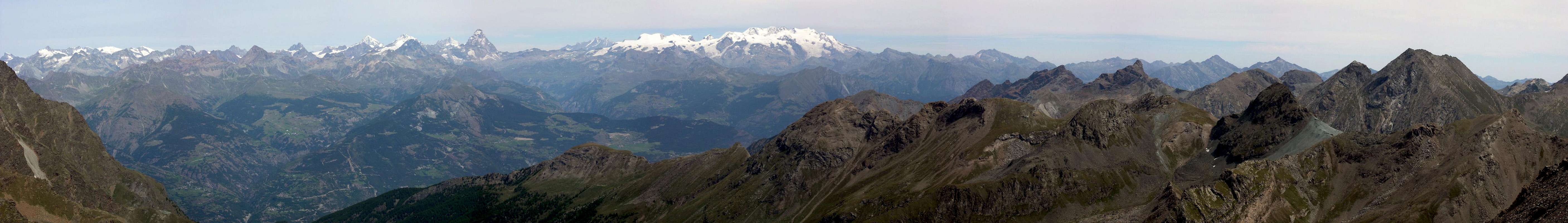
Upper Lakes Vallon from Mont Rafray (3.147m), by emilius
![]()
Mont Avìc Miners? No almost Mountaineers!, by Natalino Massoni ^^^^^^ ![]()
Mont Avìc, the first climbers? Surely the Miners, by emilius ^^^^^^
Ma questa, oltre che dei Laghi, é anche la Valle delle Miniere e del Parco Naturale del Monte Avic, i margini Meridionali del quale raggiungono, dopo aver superato lo spartiacque, anche la Valle di Champorcher fino al Torrent Ayasse. Lo stesso é stato istituito dalla Regione Autonoma della Valle di Aosta con Legge Regionale n°66 del 19 Ottobre 1989 che inizialmente riguardava solamente il territorio della parte medio-alta della Valle di Champdepraz, ma con successivo (2003) ampliamento delle aree protette che, oltrepassando la Catena del Mont Glacier, giungono fino a Dondena. Nel medesimo esiste una Fauna tradizionale per la Valle (stambecchi, camosci, aquile ecc.) ed una Flora con alcune peculiarità come il pino uncinato. Diversi percorsi segnalati con pannelli istruttivi danno variegate informazioni tra le quali anche sulle diverse vecchie torbiere esistenti. Devoluto alla conservazione del patrimonio naturalistico, é rivolto allo sviluppo di un Turismo"dolce" e che sappia entrare in punta di piedi nel Parco, non ultime le scolaresche che fanno annotare numerose visitazioni. Il Parco offre un territorio che sia le attività rurali che quelle minerarie hanno modificato appena marginalmente, mentre l'Ente ha rivolto le sue particolari attenzioni alla salvaguardia dei sentieri compiendo numerose opere di restaurazione dei medesimi, anche tramite rinforzi. La parte più elevata offre, oltre ad un buon numero di specie vegetali rare e localizzate, formazioni geologiche legate ai circhi glaciali, ormai scomparsi, ma i segni dei quali son rimasti impressi su grandi banconate di roccia levigata e su estesi depositi morenici. Al Villaggio di Voella o Chevrère, all'ingresso del Parco, esiste uno specifico Ufficio per i varii "renseignements", oltre a dépliants ed panneaux esterni. Un lungo sentiero in pietra é stato costruito per "avviare" al Parco, tanto bello da vedersi quanto duro da percorrere al rientro da lunga e faticosa escursione. Forse l'unica nota stonata ...
^^^^^^
A bit of History and some Curiosity
But this vallon or small valley has a History? Sure, but we must have a little patience in doing research; certainly easier against Courmayeur with the Mont Blanc, the Matterhorn by Cervinia, Cogne of Gran Paradiso or Champoluc and Gressoney for the Valleys of Monte Rosa. Here it is necessary instead to go to "scrape with fingernail", but we will find something. A little left to itself, a little to the pleasure of being so, this valley until the sixties lived a life of its own with its 730 inhabitants about (in 1734 were 693, in 1911 832 and in 1991 642), the mail, the telephone, the Hotel "Monte Avic" in locality "Fabbrica" , the "Locanda Buillas" and the "Cellar"; for the telegraph had to get off at Verrès. Before the opening of the Park of Monte Avic. But before that? It was place for Miners with the Mines of pyrite and chalcopyrite to Crestaz before Hérin Villages (1.293m, 1.463m) and those of iron with copper above Voella until upward to Lake Gelato (2.597m), under Mount Iverta and The Inverse of Lake Gelato, where the ore was carried downstream (Fabbrica) with the mules and winter with large sleigh gliding down the trail. From there it dominated seven valleys and January 29 was made the Patron Saint: St. Francis de Sales. From the valleys of the Monte Rosa had dropped the "Walser", the population of the Germanic race and the German-speaking, that coming from the Swiss Valais, having colonized the Valleys of the Lys and Gressoney, had crossed the Dora Baltea beginning to expand themselves on the opposite side. As evidenced by the names of Viering, ie Fiering or fence of "Feyes" or the sheep, and Getta also Gettaz des Allemands. Top goats roamed legacy Salassians who lived here even before, in order to escape the hordes of the Romans; but they not had great difficulty in doing so mingling with chamoises and ibexes upward for wild precipices of Revìc, Aü and Invers of the Lake Gelato. The Abbot Henry in "Histoire et Religieuse Civil de la Vallée d'Aoste Tome I and II", Published in Aosta in 1929, makes derive the name from "Fields plundered" by connecting the same to the floods, that with the flooding destroyed the land; for us it all seems too "sophisticated" and trace back to the same simple, certainly for the peasants of the time, "Field of the Meadows". Around the year 1000 these lands were owned by the Lordship of Montjovet or Mount of Jupiter and were known as the "Rivière de Montjovet". On the death of Faydino Mongiove in 1295, the Feud became property of the Lords of Challant, but gradually the foundations were laid for the Autonomous Commune, that took place in 1586. The Ancient Regime, controlled by the Church, was gradually absorbed by the Duchy Aosta with its Laws Economic and Civil; the Royal Edict of 1762 and "Royales Constitutions" of 1770 came unto Supplementary Regulations for the Aosta Valley of 1773. This led to the liberation of the assets, as well as the complete abolition of the Authority Feudal throughout, leaving consequently all the duties of maintaining the same to the various Communities of the Duchy since October 1th, 1783. The opening of the Park has given a considerable boost tourism and evolutionary in this valley and today everything is here today and become "modern". Do not you find more Salassians, Romans and even the Walser but a native population a little yes, that does not even feel the influence too dialect of Piedmont as the "Bassa Valle or Lower Valley"; detachment from the influences of the Po Plain and Canavese (Western Piedmont) at the gates of Pont Saint Martin small Town is evident, while to the other side in the middle there is the Champorcher Valley. The opening of the Refuge Barbustel nearby Lake Bianco (2.157m) has partly filled this gap, because there are many hikers of Piedmont from Château, bypassing the Lago Bianco Hill (2.308m), that here they come. But not many from below, because the route from Voella along the Vallon Torrent Chalamy and Lake of the Serva (1.801m), after leaving the trail on the right for the Mines of Lake Gelato, is very long, complicated despite the warnings and above all very tiring. Not everyone has the desire to follow her. We did it at the beginning of the eighties, in times less "suspicious and most intact" with signals almost non-existent with the risk of getting lost. We got lost. Going down under the dark, below a tremendous rainstorm and behind that terrible lightning chased us undeterred and with a child 10 year old ... Today in Champdepraz, but also upwards to Voella, everything has evolved. We find, as everywhere, a little of everything: the inauguration of the new bridge over the Dora Baltea, which took place June 4, 1950, had begun to "bind" this valley more to those of the "Lower Valley" constituting perhaps the beginnings to what would become the Regional Park. Many are the social services that the Municipality offers from those of the schools and to these we must record since 1967, thanks to the efforts of Mrs. Natalia Bressan and the Master Giuseppe Cerruti, the formation of a Choir, followed in recent times by a male-only (obvious!), composed of a fixed number of 16. since 1971, there is a Sports Football Club and since 1973 the Association "Penne Nere or Black Feathers" founded by the former "Alpini", while in 1978 the Association "Lé vyie tradichon", followed by "La Compagnie de theatre", La maitrise" and since 1990 the local Carnival. Among the famous people we must note the Poet in dialect Césarine Binel (1897-1956), the Priest of Donnas Don Jean Riccarand (1890-1976), Vicar Montjovet 1919-1922 and then Parish Priest of Champdepraz 1922-1970, but above the Engineer Lino Binel (1904-1981), Partisan as well as great Mountaineer companion of many exploits with Amilcare Crétier of Verrès (1909-1933 Matterhorn), this last great lover of Mount Avic already from youth.
^^^^^^
Ma questo vallone o piccola valle possiede una Storia? Sicuro, però bisogna avere un pò di pazienza nel far la ricerca; certamente risulta più facile nei confronti di Courmayeur con il Monte Bianco, Cervina con il Cervino, Cogne con il Gran Paradiso o per Champoluc e Gressoney per le Valli del Monte Rosa. Qui é necessario invece di andare a "grattar con l'unghia", ma qualcosa pur troveremo. Un poco abbandonata a sé stessa, un pò pel piacere di così essere, questa valle fino agli anni sessanta viveva una vita a sé stante con i suoi 730 abitanti circa (nel 1734 eran 693, nel 1911 832 e nel 1991 642), la posta, il telefono, l'Albergo "Monte Avic" in località Fabbrica, la "Locanda Buillas" e la "Cantina"; per il telegrafo era necessario scendere in Verrès. Prima dell'apertura del Parco del Monte Avìc. Ma ancor prima? Era posto per Minatori con le Miniere di pirite e di calcopirite presso Crestaz ed Hérin (1.293 m, 1.463m) e quelle di ferro con rame sopra Voella fino a sù al Lago Gelato, sotto il Monte Iverta e L'Invers del Lago Gelato, dove il minerale veniva portato a valle ("Fabbrica") coi muli e d'inverno con gli slittoni, che scivolavan giù per la mulattiera. Da lì si dominavan sette vallate ed il 29 di Gennaio s'effettuava la Festa del Patrono: San Francesco di Sàles. Dalle vallate del Monte Rosa eran discesi i "Walser", popolazione di razza germanica e di lingua tedesca, che arrivando dal Vallese svizzero, dopo avere colonizzato le Valli del Lys e di Gressoney, avevan oltrepassato la Dora Baltea iniziando ad espandersi sull'opposto versante. Come testimoniano i nomi di Viering, cioé Fiering o recinto delle "Feyes" ovvero le pecore, e di Getta o Gettaz des Allemands. In alto scorazzavano le capre retaggio dei Salassi che qui abitavan ancor prima, onde sfuggire alle orde Romane; ma non avevan gran difficoltà a farlo mischiandosi con camosci e stambecchi sù pei selvaggi dirupi di Revìc, Aü ed Invers del Lago Gelato. L'Abbé Henry in "Histoire Religieuse et Civile de la Vallée d'Aoste Tome I e II", Edito ad Aosta nel 1929, fà derivare il toponimo da "Campi depredati" collegando lo stesso alle alluvioni, che con lo straripamento distruggevano i terreni; per noi il tutto par troppo "sofisticato" e riconduciamo lo stesso al più semplice, sicuramente per i contadini dell'epoca, "Campo dei Prati". Intorno all'anno 1000 questi terreni eran di proprietà della Signoria di Montjovet o Monte di Giove ed eran conosciuti come la "Rivière de Montjovet". Alla morte di Faydino di Mongiove nel 1295, il Feudo divenne proprietà dei Signori di Challant, ma a poco a poco vennero gettate le basi per il Comune Autonomo, fatto verificatosi nel 1586. "L'Ancient Régime", comandato dalla Chiesa, progressivamente venne assorbito dal Ducato d'Aosta con le sue Leggi Economiche e Civili; l'Editto Reale del 1762 e le "Constitutions Royales" del 1770 s'accostarono a Regolamento particolare per la Valle del 1773. Ciò condusse all'affrancamento dei patrimoni, nonché all'abolizione completa dell'Autorità Feudale su tutto il territorio, demandando di conseguenza tutti i doveri di mantenimento del medesimo alle varie Comunità del Ducato dal 1 d'Ottobre 1783. L'apertura del Parco ha dato notevole spinta turistica ed evolutiva a questa vallata ed oggi tutto é qui diventato attuale e "moderno". Non trovate più Salassi, Romani e neppure i Walser ma una popolazione autoctona un pò sì, che non sente neppur troppo l'influsso dialettale piemontese come nella "Bassa Valle"; il distacco dalle influenze della Pianura Padana e del Canavese alle porte di Pont Saint Martin é evidente, mentre dall'altra parte in mezzo c'é la Valle di Champorcher. L'apertura del Rifugio Barbustel al Lago Bianco ha in parte colmato questo distacco, perché sono molti i piemontesi che da Château, scavalcando il Colle del Lago Bianco, qui arrivano. Non molti da sotto, ché la strada da Voella lungo il Vallone del Torrent Chalamy ed il Lago della Serva (1.801 m), lasciata sulla destra la mulattiera per le Miniere del Lago Gelato, é molto lunga, complicata nonostante le segnalazioni e, soprattutto, molto faticosa. Non tutti han voglia di percorrerla. Noi l'abbiam fatto all'inizio degli anni ottanta, in tempi meno "sospetti e più integri" con segnalazioni quasi inesistenti e col rischio di perdersi. Ci siam persi. In discesa, col buio, sotto tremendo temporale coi fulmini imperterriti ed un bambino di 10 anni ... Oggigiorno a Champdepraz, ma anche sù a Voella, tutto s'é evoluto. Troviamo, come dappertutto, un pò di tutto: l'inaugurazione del nuovo ponte sulla Dora Baltea, avvenuta il 4 di Giugno 1950, aveva iniziato a "legare" maggiormente questa vallata a quelle della "Bassa Valle" costituendo, forse, i prodromi a quello che sarebbe divenuto il Parco Regionale. Molti sono i Servizi Sociali che il Comune offre a partire da quelli scolastici ed a questi dal 1967 dobbiamo registrare, grazie alle iniziative della Signora Natalia Bressan e del Maestro Giuseppe Cerruti, la costituzione di una Corale, seguita nei tempi recenti da una per soli uomini (scontato!), composta dal numero fisso di 16. Dal 1971 esiste un Club Sportivo Calcistico e dal 1973 l'Associazione "Penne Nere" fondata dagli ex Alpini, mentre sono del 1978 l'Associazione "Lé vyie tradichon", seguita dalla "La Compagnie de théatre", "La maitrise" e dal 1990 il Carnevale locale. Tra i personaggi illustri da annotare la Poetessa in dialetto Césarine Binel (1897-1956), il Prete di Donnas Don Jean Riccarand (1890-1976), Vicario a Montjovet dal 1919 al 1922 e poi Parroco di Champdepraz dal 1922 al 1970, ma soprattutto l'Ingegner Lino Binel (1904-1981), Partigiano nonché grande Alpinista e compagno di molte imprese col verreziese Amilcare Crétier (1909-1933 Cervino), quest'ultimo grande amante dell'Avìc sin dalla primissima gioventù.
![]()
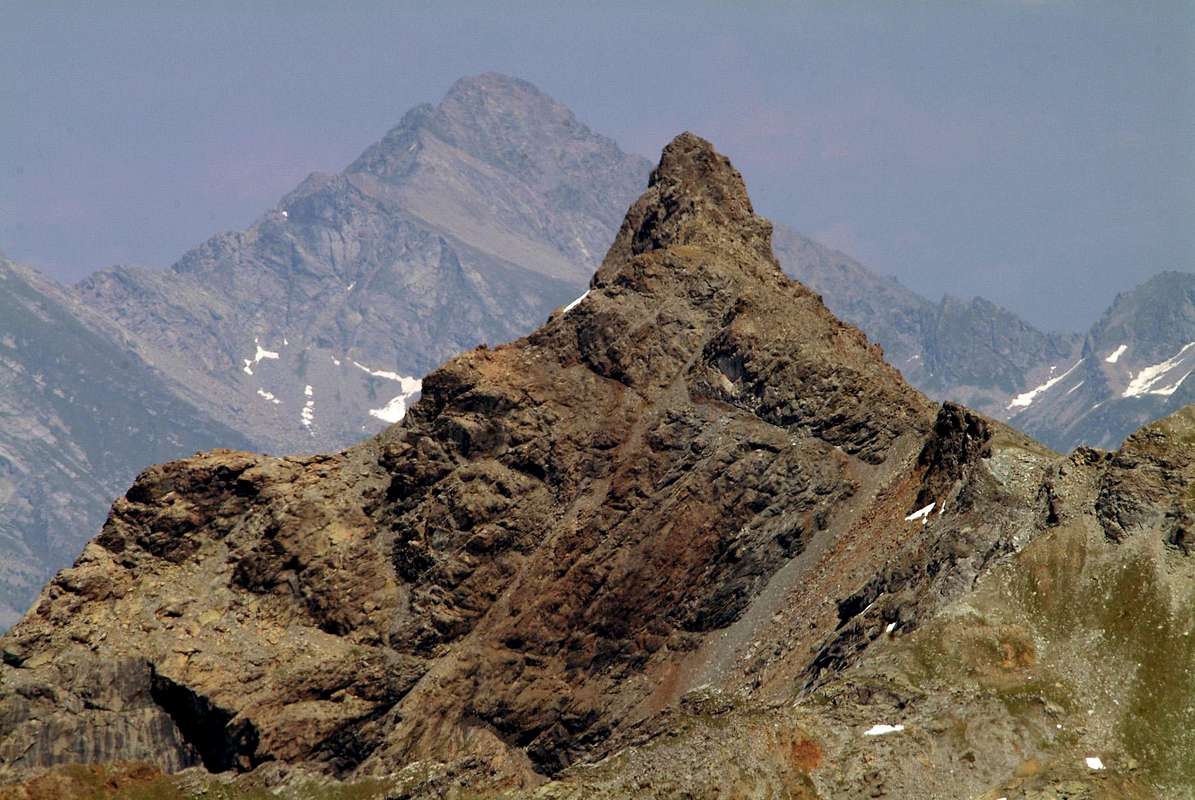
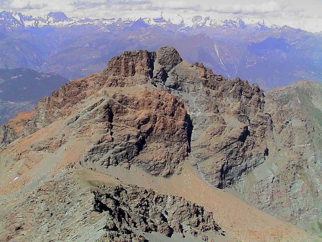
"Invers del Lago Gelato to Iverta, Avic, Ruvic & the vallons of the ancient Iron-Coppermines", by emilius ^^^^^^^
![]()
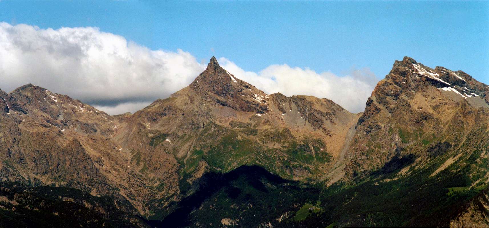
Eastward to Monte Avìc Group: (from left) Punta Nera, Mont Giron, Mont Rouvì, Mont Avìc, Mont Iverta & Invers del Lago Gelato, by Zed ^^^^^^
Getting There
BY CAR:
- From TORINO, MILANO, etc: Motorway A5. Exit at IVREA or Quincinetto (PIEDMONT) From IVREA Town: in West (Southern side) to Pont Saint Martin, Donnas, Bard, Champdepraz Municipalities. Southern Side: From Pont Bozet (775m) to Champorcher Valley, Camporcher-Château (1.427m), Petit, Grand Mont Blanc, La Cort Villages, towards Dondena Village (2.092m), Dondena & Miserin Refuges, through Royal Road and dirt roads; Barbustel Refuge, through Royal Road and path towards Champdepraz Vallon. From Hône-Bard towards Champdepraz (523m) and from this to Lakes Vallon and Voella or Raye Chevrères Village (1.307m; by Regional Road). Barbustel Refuge with path from Voella.
- From FRANCE: through the Mont Blanc Tunnel to Entrèves-crossroads to Vény/Ferret Valleys - Mountain Guides of Courmayeur - La Saxe Rock Gym - Courmayeur. By Little Saint Bernard Pass, closed since November until half May to La Thuile Valley - Pré Saint Didier - Courmayeur. It is not necessary to take Motorway A5: you can drive on SS.26, in the direction of AOSTA - IVREA - TURIN.
BY PLANE:
- Aeroporto "Corrado Gex" Saint Christophe (Aosta).
Champdepraz & its small Valleys
This area is determined by the course of the River Dora Baltea in his tract medium-low and extends from West towards East by the Municipalities Fénis to those of Chambave, Pontey, Châtillon (beyond the Dora Baltea), Champdepraz, Montjovet, Verrès (always beyond the Baltea), Issogne and Hône-Bard; latter, often packaged as name, actually is divided into two municipalities: one to the North of Baltea, "perched" against the nearby mountain, and the other, with its famous Fort overlooking the Baltea, on the opposite side of the same at the entrance of the Valley of Champdepraz. This last can be, for its length and breadth, be in effect a real valley full blown. It has very rich iron mines (now abandoned altogether) and is home to the Natural and Regional Park of Mount Avic, rich in diverse Flora and Fauna beautiful. Its vallons are of a unique wild beauty and ending at the top with the Walloon of the Lakes, bordered to the South by the Champorcher Valley and to the West by the Vallon of Savoney, secondary branch of the Fénis-Clavalité-High Comba Tersiva. So basically the Champdepraz Valley and its Park to border with well five other neighboring Municipalities, listed here from West to the East.
^^^^^^
- VALLEYS & small valleys In order to deploy clockwise from Middle/Low and Champorcher Valley to Champdepraz Vallon & Internal Areas
Lakes Vallon:
1) - from Voella in South to Alp La Serva (1.540m) and Lake (1.801m), Bayet Alp (2.071m), Cousse Alp (2.051m), Refuge Barbustel, with path. From this:
2) - in Southeast Lake Vallette (2.170m) to Col de la Croix (2.287m) and Cima Piana, with path;
3) - in South to Lake Bianco Hill (2.309m) and Champorcher Valley, with paths.
4) - In West-southwest to Bianco, Nero, Cornuto (2.172m) Lochs, Pisonet Alp (2.300m), Gran Lago (2.492m) near Forest Rangers Bivouac (private), Leità Lakes (2.540m), Medzove Pass (2.614m) to Savoney Vallon in Fénis-Clavalité Valley, with paths.
5) - in South Mount Glacier (3.186m), through North-northeast Edge (passages of I°/II°);
6) - in North on watersheed Champdepraz/Ponton Medzove Point, easily with traces. ![]()
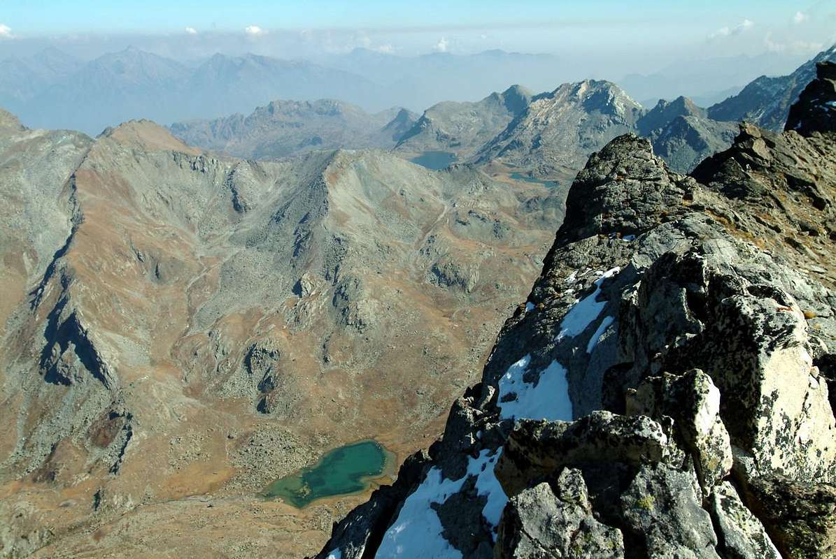
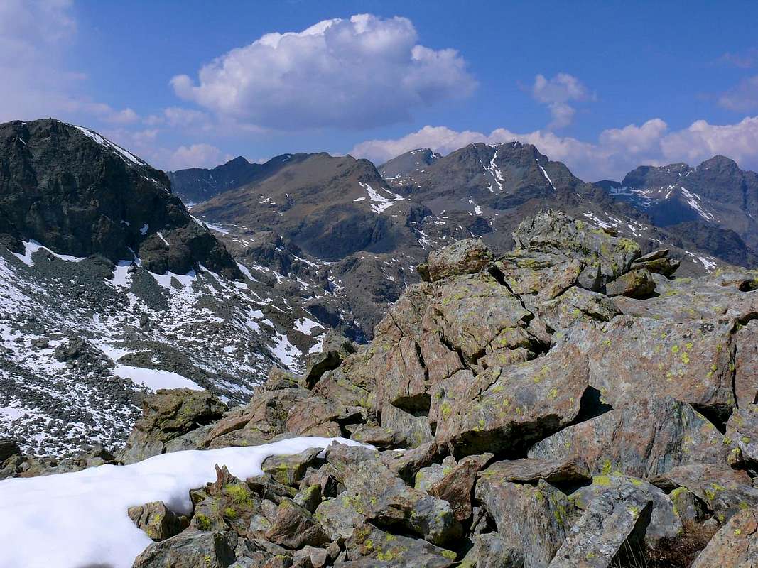
Champdepraz Upper Lakes (Gran Lago & Leità) from Mont Rafray, by emilius ^^^^^^
^^^^^^ ![]()
"Cooked and burnt by the sun Vallons of Ponton/Champdepraz stretching from Avic to Revì", by emilius ^^^^^^^
MAPS:
The Great Gorge: from Voella Village in South Alp La Serva (1.540m) and Lake (1.801m), with path and through moraines into La Gorge, wild wallon between L'Invers del Lago Gelato ("To the North than Frozen Loch"; 2.915m) and Mount Orso ("Bear"; 2.717m). Rarely path if not by local experts.
Lake Gelato Vallon: from Voella towards Pra d'Oursi Pasture (1.791m; signals), Lake Gelato (2.597m) and Ironmines (2.616m) near Forest Rangers Shelter, with muletrack and path, to
1) - in Southwest Raye Chevrère Hill (2.703m), Lake (2.751m) and Mount Iverta (2.939m) through traces, moraine and "clapeys" (boulders);
2) - in Southeast towards L'Invers of Lake Gelato Hill, Collar and Point (2.915m), by path and in final traces on short and easy Southern Crest.
Varotta Vallon: from Voella, Prà d'Oursy and always in West to the Varotta Hill (2.589m), between Mounts Avic/Ruvic, to Ponton Vallon, with paths.
Barbeston Vallon: from Voella towards Praz d'Oursy and in Northwest Plan Tsaté Alp, Valmeriana Hill (2.281m) to Mount Barbeston (2.482m), with path.
Filone-Barbeston/Lyan Vallon: from Champdepraz towards Crestaz (1.293m), Cugnon, Losson (1.353m), Hérin (1.463m) or from Barbuste (1.240m) Villages in West
1) - Arp Alp (1.542m) to Mount Barbeston, various paths;
2) - in North-northwest to the Coppermines and Mount Lyan (2.178m), paths.
Quest'Area é determinata dal corso del Fiume Dora Baltea nel suo tratto medio-basso e si estende da Ovest verso Est dal Comune di Fénis a quelli di Chambave, Pontey, Châtillon (al di là della Baltea), Champdepraz, Montjovet, Verrès (sempre al di là della Dora), Issogne ed Hône-Bard. Quest'ultimo, spesso assemblato come denominazione, in realtà é suddiviso in due ben distinte municipalità: una a Nord della Dora Baltea arroccato contro la montagna e l'altro con il suo famoso Forte a strapiombo sulla Dora Baltea sulla sponda opposta della medesima all'ingresso del Vallone di Champdepraz. Quest'ultimo può essere, per la sua lunghezza e vastità, essere a tutti gli effetti una vera e propria valle in piena regola. Esso possiede miniere di ferro alquanto ricche (oggi abbandonate del tutto) ed ospita il Parco Naturale del Monte Avic, ricco di Flora e di Fauna. I suoi valloni sono d'una bellezza selvaggia unica e terminano nella parte superiore con il Vallone dei Laghi, confinante a Sud con la Valle di Champorcher ed ad Ovest con il Vallone di Savoney, ramo secondario di quello di Fénis-Clavalité-Alta Comba Tersiva. Quindi la Valle di Champdepraz ed il Parco confinano con ben altri cinque Comuni viciniori, qui elencati da Ovest ad Est.
Mountain Conditions
- You can get meteo information at the official site of the Regione Valle d'Aosta:
- Valle d'Aosta Meteo
Webcam
- WEBCAM on Aosta Valley:
- Webcam
Books and Maps
BOOKS:- "Guida delle Alpi Occidentali" di Giovanni Bobba e Luigi Vaccarone C.A.I. Sezione di Torino Volume II (parte II), 25 Maggio 1896.
- "Guida dei Monti d'Italia–Emilius Rosa dei Banchi Parco del Mont Avic" di Giulio Berutto e Lino Fornelli-Club Alpino Italiano/Touring Club Italiano, Marzo 2005 (in Italian).
- "A piedi in Valle d'Aosta" (Vol. 2), di Stefano Ardito, Ed. Guide iter, Giugno 2004.
- "I Rifugi della Valle d'Aosta" di Stefano Ardito, Ed. Guide iter, Febbraio 2003.
- "Rifugi e bivacchi in Valle d'Aosta", di Cosimo Zappelli aggiornata da Pietro Giglio, Musumeci Editore, Luglio 2002.
- "Guida della Regione Autonoma Valle d'Aosta" di Mario Aldrovandi; Ed. S.P.E. di Carlo Fanton, Torino 1964.
- "Parco Naturale Mont Avic" di Naldo Finco e Luca Zavatta, l'Escursionista Ed., Giugno 2006.
- "Ascensioni in Valle d'Aosta 1921-1933" Diario Alpinistico di Amilcare Crétier; Edizione Sezione di Verres del C.A.I. e Biblioteca di Vèrres, stampa Arti Grafiche Tamari Bologna, Luglio 1993 (in Italian).
 |
 |
 |
 |
 |
 |
- Kompass "Gran Paradiso Valle d'Aosta Sentieri e Rifugi" Carta Turistica 1:50.000.
- L'Escursionista "Parco Naturale del Mont Avic" Carta dei Sentieri 1:25.000.
- Enrico Editore Ivrea-Aosta "Gruppo del Gran Paradiso" 1:50.000.
- I.G.C. Istituto Geografico Centrale Torino "Ivrea Biella Bassa Valle d’Aosta" (n° 9), 1:50.000.
- I.G.C. Istituto Geografico Centrale Torino "Il Parco Nazionale del Gran Paradiso" (n° 3), 1:50.000.
- Ingenia "Parco Naturale del Mont Avic" Carta dei Sentieri 1:25.000.
- Hapax "Les Sentiers Comunità Montana Monte Emilius", Luglio 2000 1:25.000.
- Hapax "Les Sentiers de Champorcher" Comune di Champorcher, Agosto 2001, 1:25.000.
Important Information
- REGIONE AUTONOMA VALLE D'AOSTA the official site.
- FONDAZIONE MONTAGNA SICURA Villa Cameron, località Villard de la Palud n° 1 Courmayeur (AO) Tel: 39 0165 897602 - Fax: 39 0165 897647.
- A.I.NE.VA. (Associazione Interregionale Neve e Valanghe).
External Links
Useful numbers
- Protezione Civile Valdostana località Aeroporto n° 7/A Saint Christophe (Ao) Tel. 0165-238222.
- Bollettino Meteo (weather info) Tel. 0165-44113.
- Unità Operativa di Soccorso Sanitario Tel. 118.