
|
|
Area/Range |
|---|---|
|
|
45.87471°N / 7.92114°E |
|
|
Hiking, Mountaineering, Skiing |
|
|
Spring, Summer, Fall, Winter |
|
|
15276 ft / 4656 m |
|
|
Overview
Valsesia, together with Ossola valley, can be considered as the most important area of the Northeast of Piedmont.The groove of the valley ascends from the small village of Serravalle Sesia (Serravalle means “valley locker”) to the wild and almost Himalayan cirque located under the huge south face of Monte Rosa (4632m, the second summit for elevation in the Alps), where Sesia river borns from the glaciers of the mountain.
The valley embraces a wide variety of environments, from the green nice hills of its lower part to the dramatic ice covered peaks of Monte Rosa range.
Every spring and summer a large number of mountaineers and ski-mountaineers, coming from all over the World, starts from Alagna, the most famous locality of Valsesia, to climb Punta Gnifetti (4559m) and reach on its top Margherita hut, the highest mountain hut of Europe.
The lift that from Alagna gets to Salati pass, at 2980m, shortens the approach to the high peaks of Monte Rosa, and during winter offers great possibilities for skiing and free-riding, such as that Alagna earned the nick name of “Free-ride Paradise”.
 The upper cirque of the valley under Monte Rosa
Monte Rosa is surely the most important mountain massif, with more than ten summits above the line of 4000 meters and a large variety of routes, from the easy ones on huge glaciers to the severe ones on remoted walls and gullies.
After Monte Rosa the iced Punta Grober, the fierce Corno Bianco(3320m) and the rugged pyramid of Monte Tagliaferro(2964m) are the most notable peaks of the area. Theyr flanks and the ones of their satellites summits offers possibilities for rock climbing, hiking and also for ski-mountaineering.
Valsesia embraces in its territory numerous lateral valleys where other lower ranges attend during summer the hiker with nice woods, green meadows and easy ridges, and during winter the ski-mountaineer, with fancy slopes for all the level of skill.
Val Sermenza, Val Mastallone, Val Vogna, only to mention some of them, are fancy areas where you can venture in every season, in absolute piece and often solitude.
Sesia and its feeders are famous for kayak and rafting sports, the best season for these activities is without doubt spring, where the melting of the snow, together with the frequent rain falls, ensure abundance of water.
In the Northern part of the area, under Monte Rosa and the summits of Tignaga range, High Sesia natural (Parco Naturale ALta-Valsesia) park defends the wild life of this area.
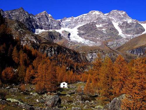
 Typical colours of the valley
Getting There
The quickest access by car to the valley is from the highway A26, that connects Milan to Genova.After the exit of Romagnano Sesia, a good road lead to the entrance of the valley and goes on till Alagna where it ends under the cliffs of Monte Rosa.
Also the secondary valleys have their own paved road that reaches lovely villages, like Rima in Val Sermanza or Santa Maria in Val Mastallone, where is easy to find an accomodation.
The access by train is easy by the town of Novara, not far from the Malpensa Airport or from the city of Milan. The Railway ends in the town of Varallo, where you can then go on by bus to reach Alagna, or almost all the other interesting localities of the area.
 Map of the valley
Red Tape
No permission are required, these mountains and rivers are free all over the year.The sub-ranges of Val Sesia
Monte Rosa GroupThis range has two faces reachable by Valsesia, the easy west one, that can be quickly approached by the Salati pass cable-lift, and the rugged south face, overtopping the ending cirque of Valsesia with rocky cliffs and steep iced couloirs.
Some classical routes are the ridges of Lyskamm, the normal route to Punta Gnifetti and the Signal ridge.
Also the normal route to Doufur Spitze(4632m), the highest peak of the range and the second summit for elevation of the Alps, can be engaged from Salati pass.
For the collectors of 4000s there are various possibilities to cross the summit ridge that connects the higher peaks of the range and climb more than one summit in one day.
The South flanks offers very severe routes (some of them evaluated TD, very difficult, UIAA scale) on rock and ice in a remote environment that requires a long approach.
 Monte Rosa from Val Sesia
 The Ridge from SW
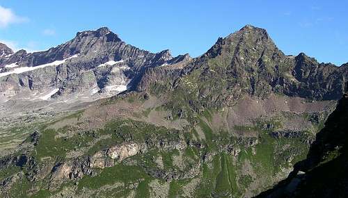
Punta Grober range
At East of Monte Rosa, separated from it by Signal pass, this range belongs to the long watershed between the valleys of Sesia and Anza Rivers.
The most important summit is Punta Grober (3495m), which is often climbed and offers fantastic views and some classical route on rocks or on ice over the south and north faces.
At East of Punta Grober other three summits called Punta Rizzetti, Punta Calderini and Monte Turlo, all above 3000m, form the small Faller Ridge. They can be easily climbed also by hikers but they are rarely visited, the view from their top is anyhow very interesting and the ascent is pleasant.
The trailhead for this range is alagna.
 Punta Grober and Monte Turlo
Corno Bianco range
This range ambraces the summits of the lateral valleys of Otro and Vogna, immediately at SW of Monte Rosa, including the watershed with Valle D’Aosta.
There are 5 mountains with an elevation above or near 3000 meters, with Corno bianco(3320m) overtopping all of them.
The valleys of Otro and Vogna are two untouched wilderness islands, with numerous remote cirques and hanging valleys to discover along the long trails tha offers.
There are fantastic possibilities for well trained hikers or ski mountaineers.
The long N ridge of Corno Bianco is a not difficult rock climbing route, while the NE Pillar is very difficult and dangerous due to its remote position and to the sometines unfirm rocks.
The normal routes to Corno Bianco from Rissuolo valley or from Thaily lakes and the normal route to Straling (3115m) from Otro valley are two formidable hiking experiences, with more than 2000 meters of elevation to gain and a distance to cover major than ten kilometers.
Also Corno Rosso, also called Punta Carestia (2979m), on the watershed with Valle D'Aosta, is very pleasant to climb from the normal route starting from Valdobbia pass and the view from the top is great.
Numerous small alpine lakes contour the slopes of Corno Bianco and Corno Rosso., The lovliest of them are those of Rissuolo cirque and the Thaily ones.
The trailheads are the villages of Alagna and Riva Valdobbia.
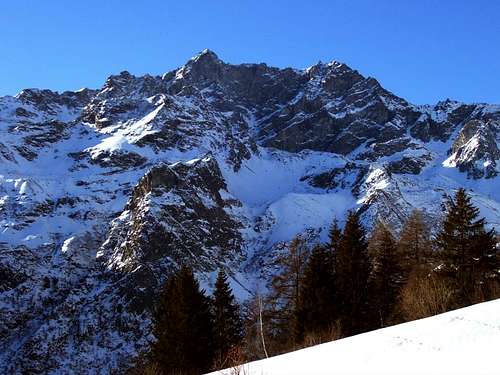 Corno Bianco in Winter from Otro Valley
 Corno Bianco Range seen from East
Mount Tagliaferro range
This range is the watershed between the valley of Alagna, often called Valgrande, and Val Sermenza. The slopes of these mountains can thus be approached from both these valleys.
There are numerous hiking possibilities, the normal route to Tagliaferro from the south ridge is the most classical one, it gains more than 1600 meter of altitude and the view from the top is astonishing, embracing Monte Rosa, the most of the Western Alpine range and the great lakes Maggiore and Orta.
The N ridge of Tagliaferro, is one of the most frequented rock climbing route of the valley, while the north wall is an impressive shield of rock with a prominence of more than 800 meters.
The southern summits of this range are not very high but their environment is a perfect island of wilderness.
All the villages at north of the one of Balmuccia, both in Sermenza valley and in the main valley of Sesia river can be used as basis for this group.
 Tagliaferro and Corno Mud from the green meadows of Alpe Campo
Palanca-Meia-Cossarello range
This range is located at South of the one of Corno Bianco, on the hydrographic right of Vogna river, embracing the summits of the small valleys of Artogna, Gronda and Sorba rivers.
The elevation is always under 3000 meters, there are numerous hiking possibilities but the summits are rarely visited.
The trails are in fact signed only to the highest passes of the valleys, to reach the summits from these passes you must often invent the route by your own, thing that can be fun cause the difficulties are never high.
The “gates” of this range are the villages of Rassa and Campertogno, at south of Alagna.
 Monte Palanca from Vogna Valley in early Autumn
Monte Vecchio – Tignaga range
This range is located at east of Tagliaferro ridge and closes at North Sermenza and Egua valleys froming the watershed with the valley of Anza river.
The highest peak is Pizzo Monte Vecchio (2738m), which north ridge is short but easy and amusing rock climb on firm rock.
All these summits are rarely climbed, but they can be reached without difficulties starting from the passes at the basis of their ridges, to choose the route by your own is not difficult if you are at least an experinced hiker.
The environment is wild but not so remote due to the nearness of the small villages of Rima and Carcoforo that are good trailheads for these peaks.
The small dorsal that divides the valleys of Rima and Carcoforo can be considered as a part of this ridge.
These mountains can be approached also from North, starting from the village of Macugnaga in Anzasca valley, across the main valley of Anza river or across the lateral valley of Quarazzola river.
 Sunset on Monte Vecchio West face
Colmetta range
This ridge divides Egua Valley from Val Mastallone. There are possibilities for hiking all over the year and also for ski mountaineering.
The highest summit is Cima Colmetta(2458m). Cimone di Camposecco(2413m) is frequently climbed from the village of Carcoforo. The trailheads are the villages of Carcoforo and Rimasco in Egua valley and the village of Santa Maria(Saint Mary) in Mastallone valley.
Capezzone-Capio range
This is the most Eastern dorsal of Valsesia, divinding Val Mastallone from Val Strona.
The highest summit is Monte Capezzone (2421m), which, like the others peaks of this range, can be climbed in one day starting from the village of Rimella without technical difficulties.
These mountains can be approached also from Strona valley, from the lovely village of of Campello ai Monti that is reachable from Orta lake.
Monte Barone range
The most southern range of the area, the highest summit is Monte Barone (2044m), often climbed in all seasons along a pleasant hiking route.
A lovely range for hikers and trekkers, especially in autumn and winter, there are also possibilities for ski-mountaineering.
Accomodation
The valley is full of possibilities, for all the budgets, with campings hotels and "bed and breakfast".See the link section.
Huts
Here after the most important huts of these areas divided by the respective range.Monte rosa
Capanna Regina Margherita (4656m), on the top of Punta gnifetti. The highest mountain hut of Europe.
Reachable from the Salati cable-lift arrival at 2980m.
Capanna Gnifetti (3600m), near Lys glacier, the trail head is Salati pass cable-lift, it’s normally used like support point for climbing all the 4000s of Monte Rosa.
Capanna Gugliermina (3400m), under Punta Parrot south face, in the upper Sesia cirque.
The trailhead is the locality called Acqua Bianca (“White water”, 1400m), at the entrance of Sesia natural park, some kilometers at north of Alagna.
Capanna Resegotti (3600m), at Signal pass, normally used to climb Signal ridge to Punta Gnifetti.
The trailhead is again the locality called Acqua Bianca.
Rifugio Barba Ferrero. Located in the upper Sesia Cirque at 2300m under Monte Rosa. The trail head is always from Acqua Bianca. It’s usefull both to climb the summits of Monte Rosa and of Punta Grober range.
 Regina Margherita hut at 4556m
Corno Biance range
Ravelli hut (2500m). In the upper Otro Valley. Reachable from Alagna in 4 hours without difficulties on a well signed trail.
Usefull to climb the 3000s of the range: Corno Bianco, Corno Grosso and Punta Straling.
Carestia hut (2200m), at the entrance of Rissuolo cirque in Vogna valley. It’s used to break in two days the long normal route to Corno Bianco or for the trekking around the peak called “Tullio Vidoni” trail.
The trail head is the locality called Sant’ Antonio (Saint Antony, 1300m) over the village of Riva Valdobbia.
Ospizio Sottile (2430m), at Valdobbia pass, on the watershed with Valle D'aosta, used to cross from Riva Valdobbia to Gressoney or to climb Corno Rosso.
A hut with a rich history, It has been used since 1800 by the pilgrims that used to cross Valdobbia pass to reach Gressoney from Riva.
The trailhead to reach this hut is once again Sant'Antonio.
Tagliaferro range
Ferioli hut (2200m), near Mud pass, reachable from Alagna or Rima and used to climb Tagliaferro and Corno Mud (2800m).
Alpe Sattal (2100m), under the west ridge of Carnera (2754m).
Is an original bed and breakfast open all the year, reachable by Alagna in less than two hours. It deserves a visit!
You can use it two climb Tagliaferro or Carnera.
Monte Vecchio – Tignaga range
Vallè hut, at 2100m, under the West face of Monte Vecchio, reachable in two hours from the village of Rima (1400m)
Massero hut, at 2000m, under the East face of Monte Vecchio, the trailhead is Carcoforo at 1300m.
Boffalora hut, at 1700m under Pizzo Tignaga, reachable in less than two hours from Carcoforo.
 Map of the huts
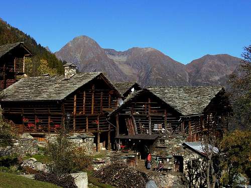
The Walsers
Walser folk has settled in the valleys of Monte Rosa during the 16th century. Val Sesia, with the villages of Alagna, RIva Valdobbia, Rima and Carcoforo is the site of numerous Walser colonies.The typical Walser architecture can be admired not only in the villages but also in the mountain settlements of Otro and Vogna valley.
A Walser museum is located in the localities called Pedemonte, a fiew kilometers at North of Alagna.
 Typical Walser architecture in Vogna valley
Links
Official SiteInformations about the accomodations, the roads, the huts and the trails.
Official site of high Valsesia Park
Official site of Alagna
Val Sesia Alpine Club detachment
Alpe Sattal official site
Regina Margherita hut
webmastercai - Jul 24, 2009 11:39 am - Hasn't voted
Regina Margherita hutRegina Margherita hut official page is now: http://www.caivarallo.it/rifugi_cai_varallo/capanna_regina_margherita_rifugio.php or www.capannamargherita.com directly