
|
|
Route |
|---|---|
|
|
38.79140°N / 104.9933°W |
|
|
Hike |
|
|
Most of a day |
|
|
Walk-up |
|
|
Quick Facts
2-wheel drive trailhead
Trailhead Elevation: 9,800'
Total Climbing: about 3,040'
Distance: 6 miles (one-way)
4-wheel drive trailhead
Trailhead Elevation: 10,300'
Total Climbing: about 2,500'
Distance: 4 miles (one-way)
 |
Approach
If you don't have 4WD, start at the intersection of Gold Camp Road and Forest Road 379. There is a parking area just past FR 379 on the left.
If you have 4WD, continue north on FR 379 approximately 1.8 miles to the Captain Jacks trailhead. This is well-signed. Look for Trail 701.
Note: This route can also be approached from North Cheyenne Canyon Park via Seven Bridges Trail, Bear Creek Trail, or Jones Park Trail. This would add several miles to the trip but would provide a more sporting option. And as SP member PurpleMountainNear points out, good camping is available at Jones Park.
Your Topo map will show all these trails. To reach the Cheyenne Canyon route, simply find your way to where Trail 701 intersects with North Cheyenne Creek.
Route Description
Hike (or drive) north on FR 379. After about 1.8 miles you'll reach the Captain Jacks trailhead.
Head north on Trail 701 (aka Foresters Trail). This is a multi-use trail so watch out for mountain bikers and dirt bikers. Continue to North Cheyenne Creek, which will be your 3rd stream crossing on the trail, somewhere between 1.1 and 1.6 miles from the trailhead.
Up to this point you'll be making great time and still feel refreshed. Don't pat yourself on the back just yet. You still have over 2,000' of climbing to do.
From the creek crossing continue some 50-60 paces along the trail. You are looking for a trail on the left that follows North Cheyenne Creek. The trail is not signed and is not obvious. Look for a cairn, but who knows if it's still there. Once you find the trail, start climbing up the canyon.
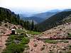
As trails go, this one is pretty steep. You'll stay to the right of the stream for some time. The canyon is nice and peaceful, and the view of the creek and the occasional patch of wildflowers will distract you from the steepness. At times you'll be well above the stream, and further along you'll be right next to it. If you do lose the trail, just keep generally following the stream and keep an eye out, you're sure to find the trail again. If the beginning of the trail isn't steep enough for you, don't worry. It gets steeper.
Somewhere about 11,500', the trail becomes quite faint and even seems to disappear. Stay close to the stream. You'll reach a point where the stream has 2 forks. Continue along the path of least resistance and find a good spot to cross to the left of both forks, before they reunite.
You should now be able to make out a faint trail on the left of the stream. Continue up the canyon until your path is blocked by a large, fallen tree. At this point, scramble up the left side of the canyon. Before long, you should re-gain the trail, and it should be much more distinct. Follow this trail to the left (east). It will switch back a couple of times. You are climbing out of the canyon but the grade is much less severe than when you were climbing up the canyon.
Soon you will see the 4WD road's gate above you. The trail then hits a T-intersection. Take the path to the right, past a sign that says "No Motor Vehicles." This path will lead you right to Stratton Reservoir.
Go around the reservoir by crossing the spillway (or hiking around the long way if necessary). Make your way north along the path, over the saddle, and on to Almagre's summit. From here you'll have a great view of Pikes Peak, whose summit is about 4.5 miles away. With your topo map you'll be able to identify many other mountains and reservoirs.
Take the time to walk around, as the view is different from different parts of the mountain. If you have time, hike over to Baldy and the radio towers for some more interesting views.
 |  |  |  |
Essential Gear
This is a dayhike totalling about 12 miles round trip. As such, you'll want to be prepared for unpredictable weather. Bring warm clothes and something to keep you dry.
Bring plenty of water, or bring a water filter. You'll be hiking near water for much of the way, so you can tank up just about any time as long as you treat the water.
Also don't forget some snacks, sun screen, and of course, your camera.
Miscellaneous Info
If you have information about this route that doesn't pertain to any of the other sections, please add it here.