
-
 14060 Hits
-
 73.06% Score
-
 3 Votes
|
|
Route |
|---|---|
|
|
38.79140°N / 104.9933°W |
|
|
Hike |
|
|
Half a day |
|
|
Class 1-2 with some route finding: 6-7 mile round trip |
|
|
Approach
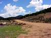
The trailhead for this airy route up Almagre Mountain is located just below the reservoir gate closure on Forest Road 376 at a four way intersection just over three miles above Gold Camp Road. Forest Road 376 is located on the right or north of Gold Camp Road when traveling west on Gold Camp Road from Colorado Springs approximately 7 miles west of Forest Road 379 (Frosty's Park Road). The intersection is well marked.Forest Road 376 follows Middle Beaver Creek which flows out of the City's reservoir system. Forest Road 376 is maintained by the City as it is the access to the City's reservoir system and currently is accessible by two wheel drive. There are multiple opportunities for camping along Forest Road 376.
 |  |
Route Description
From the small parking area on the west side of the four way intersection (10,800 feet), head east up the steep gravel road. This is the steepest part of the entire route. Follow this road up for a little over a quarter mile until it levels out around 11,250 feet. Head approximately a quarter mile past this level area losing about 50 feet of elevation until the road levels out. You will approach a fairly flat clearing on the left from which you will be able to see the Microwave Towers atop a peak to the left. Here is where the route finding begins.Head left through this small clearing heading generally northeast on relatively flat ground. After a short distance of a few hundred feet you will find a very faint double track which you will follow into a large meadow. Follow this faint double track for a few tenths of a mile through the meadow. Near the end of the meadow you will want to head northeast through the trees and up the southwest ridge that was visible from the meadow. As you climb the ridge you will pass through an old wire fence and eventually come upon a obvious trail which heads up to the saddle above Stratton Reservoir. This is easy route finding as this is a healthy forest with little undergrowth and/or downfall to get in the way.
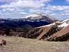
From the saddle you can chose to generally follow the summit ridge north of the saddle up to Almagre or drop down from the saddle to Stratton Reservoir and follow the double track gravel road up to the summit.
 | 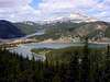 |  | 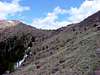 |  |
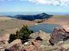
Additional Photos from above treeline
 |  |  |  |  |
Essential Gear
A map and compass is essential due to a short route finding section on this hike located below treeline. A GPS unit would be a good backup but should not be used in place of a map and compass. About half of this hike is above treeline so be sure to bring the appropriate gear.The weather forecast above 11,000 feet on Pike's Peak would be a good estimation of conditions on Almagre Mountain. Check conditions on Pikes Peak above 11,000 feet here.