
-
 15703 Hits
-
 90.22% Score
-
 32 Votes
|
|
Route |
|---|---|
|
|
Hiking, Ice Climbing |
|
|
Winter |
|
|
Half a day |
|
|
1 |
|
|
Overview
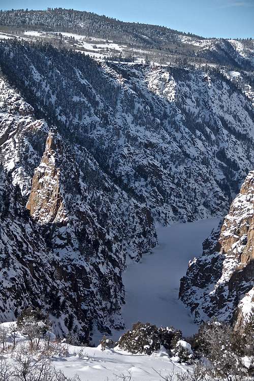 Frozen Morrow Point reservoir
Chipeta Falls is a natural waterfall that drops in the Morrow Point Reservoir, just past the dam for Blue Mesa Reservoir. It is located in the Curecanti National Recreation Area, some say Black Canyon, but that is still a few miles further west. This area is isolated and it is a perfect waterfall if you desire solitude. The approach trail and the whole location of the climb is very scenic. The climb can be top roped.
Curecanti National Recreational Area bears the imprint of attempts to alter these rugged mesas and canyons for human purposes. The most recent major alteration was the construction of three dams on the Gunnison River to provide irrigation and hydroelectric power. These damps have transformed this semiarid locale into a water based recreation mecca. Blue Mesa serves as the main storage reservoir. Blue Mesa Reservoir is 20 miles long. Morrow Point Dam generates most of the power, and Crystal Dam maintains an even flow though the Black Canyon of the Gunnison.
Curecanti National Recreation Area borders Black Canyon of the Gunnison as mentioned above. This area has many hiking trails in the summer, and many ice climbs in the winter. It is also very popular fishing destination.
Chipeta Falls are named after wife of a famous Ute Chief Ouray.
Curecanti was a name of a Ute Indian sub-chief who roamed southern Colorado from 1860s to 1870s.
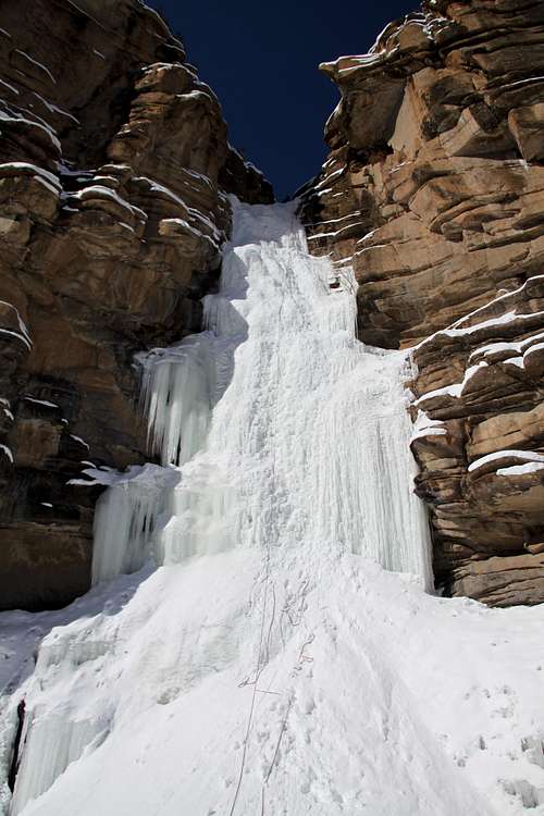
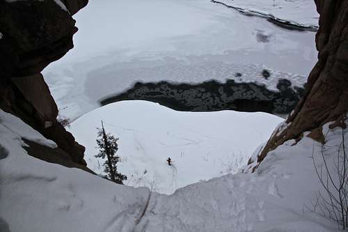
The waterfalls are easy to visit in the summer. You can take a scenic Morrow Point Boat Tour and ride through the upper Black Canyon (again, technically Black Canyon does not start until past all 3 dams) that takes you past this waterfall. Chipeta Falls drop about 160 feet.
How To Get There
Curecanti National Recreation Area is located approximately 200 miles southwest of Denver. U.S. Highway 50 runs the length of Curecanti between Montrose and Gunnison, Colorado. The recreation area is also accessed from CO Hwy 92.Directions to Chipeta Falls: Drive to the intersection of U.S. Hwy 50 and CO Hwy 92. Turn north (direction for the North Rim of Black Canyon N.P.), and drive over the Blue Mesa Dam. Measure the distance from the end of the dam; at 3.7 miles you enter a large curve, park right before the curve on a shoulder of the road. Make sure that cars can pass easily by you and you don't obstruct the curve. There is an obvious drainage with Corral Creek dropping down into the gorge with Gunnison River below. Look for any signs of a trail. We had a lot of fresh snow, but we were still able to spot a trail on the east side of the drainage. Stay higher up initially, and after about 5 min the trail will take a turn and start to drop down into the drainage. You will have to negotiate some fallen trees, but we had no difficulties finding our way down to the falls. There were signs of people using this access, e.g. broken branches on trees, and some consolidated snow despite about 10 inches of fresh snow.
There are 3 small bulges of ice right above the main ice fall. You can down climb it, or rappel it from small trees. There is a nice flat and wind protected area above the main waterfall, including a small cave. Unfortunately the belay area is shady and we had a lot of snow drift. I found 2nd set of bolts during my 2nd visit to this area just above those easy ice bulges, so you can rappel down to the start of the main ice flow.
Approach takes about 30 min (depending whether there is a broken trail or deep snow), and distance about 1.5 miles.
Route Description
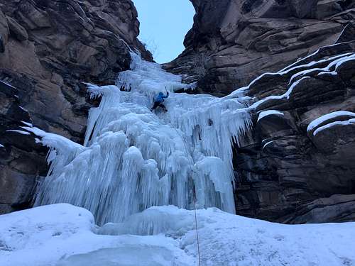
The main Waterfall Ice is about 50 merters long. We did not count the three small, cca 10 meter long bulges of WI2-3 above the main waterfall as climbing. These bulges do not form consistently and sometimes there are only short rock walls above the main waterfall. The lower section of the Chipeta Falls is flat dropping into the reservoir, and often covered with snow. The main waterfall of WI3+ is 50 meters long, could be steeper for a short section early in the season.
Anchors: 2 bolts at the top were in a good condition.
There are also anchors (2 bolts) above the main icefall - on the left side of the canyon when descending - those are very handy to reach the main anchors right above the main flow of Chipeta Falls if one wishes to rappel in.
The return took about 40 min, it is all up hill, and many icy sections were covered with snow, which made it very slippery. We had no problems to solo climb over those 3 bulges to get back to the trail. These bulges are not very exposed.
Essential Gear
Ice climbing gear: harness, helmet, boots, crampons and ice tools.Top Roping: 60 meter rope sufficient, providing that climber will use the same technique as we did (single rope rappel, and belayer stays on the top). If you wish to have both climbers on the bottom of the climb (sunny warmer place for the belayer), bring two ropes.