
-
 13512 Hits
-
 88.19% Score
-
 26 Votes
|
|
Mountain/Rock |
|---|---|
|
|
46.25110°N / 11.87340°E |
|
|
9642 ft / 2939 m |
|
|
Overview
Geographical Classification : Eastern Alps > Dolomites > Pale di San Martino > Cima della Fradusta

Cima della Fradusta seen from the Altipiano delle Pale di San Martino
Glaciers are very rare in the Dolomites. Apart from Marmolada there are only a handful of mountains which carry an ice cap but in almost all cases it is a tiny one. There are exceptions - Cima Tosa would be one - and so is Cima della Fradusta. But the hot summer of 2003 has taken its toll here too and it is somehow doubtfull how long Ghiaccaio della Fradusta will survive. Today it is already split in two parts the lower of which looks worn and washed out. Moreover July 29th 2005, when we climbed La Fradusta was a hot day - and I can hardly think of a more depressing sound than the constant rush of melting ice with occasional rockfall here and there. I doubt the glacier will survive another decade...
Cima della Fradusta is located at the centre of the Pale di San Martino Group in the southern Dolomites. It rises smoothly out of the Altipiano delle Pale di San Martino a huge - karst like high plateau, in itself as impressive as any of the beautiful mountains around. La Fradusta's south face however drops sharply 400m down into the Vallon delle Lede, a high valley which drains into Val Canali, one of the most beautiful mountain valleys on earth only to be beaten by...
... Val Pradidali on the western side of Fradusta. Yes, the setting is grand, however the views during the climb are better than the ones from the summit. Cima della Fradusta has four almost equally high summits which obstruct parts of the views from each other. To the north and west - across the Altipiano - the views roam free but to the south and east only parts of the scenery can be seen.
So why not combine the Fradusta ascent with an exploration of the Altipiano? That is exactly what we did but you have to take into account a lot of time for crossing that "plain". Seen from up close the plateau is not plain in any way - lots of hills, mountains, passes, dells follow each other. Moreover the going is rough. And be sure to follow the marked trails - there are few recognizable features and a sudden onset of fog can even become dangerous. The Altipiano looks like a moonscape - nothing seems to be growing or living here. But if you look real close you'll see an astonishing amount of wildflowers seemingly growing out of nowhere!
 |  |  |  |
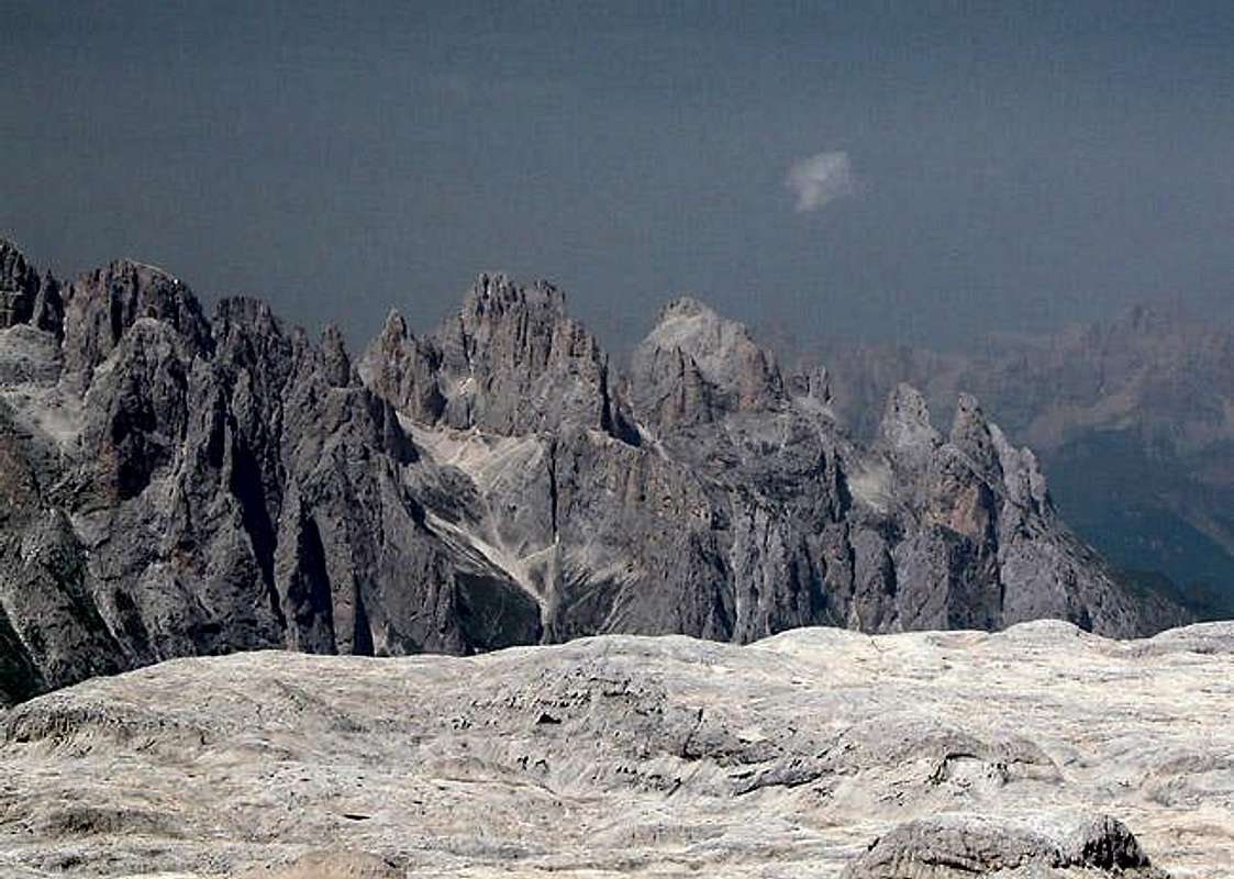
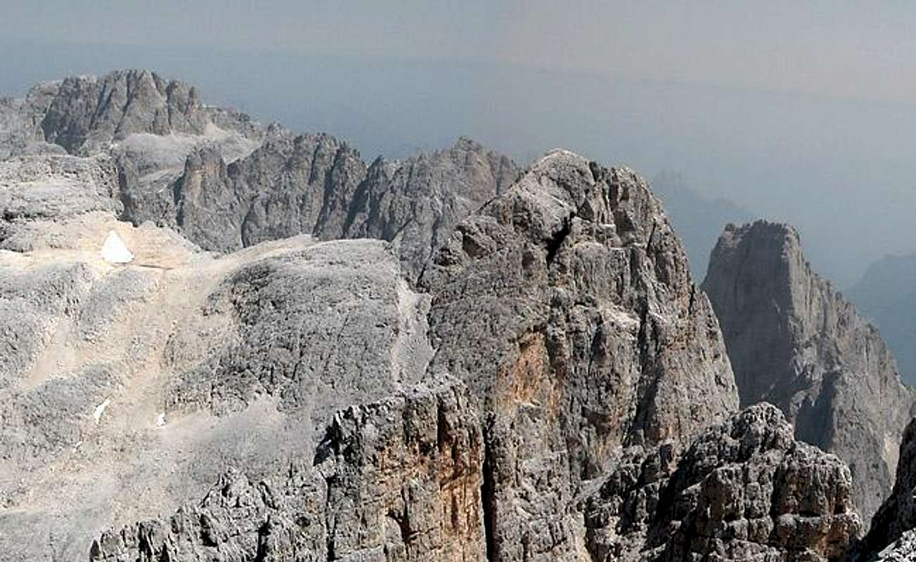
Summit views
C. CoronaCr. d. PalaCimon della PalaCol CantoniIl NuvoloC. della VezzanaC. dei BureloniC. di Val GrandeC. delle ComelleCamp. di Val GrandeCamp. FocobonC. FocobonC. di CampidoC. ZopelC. Lastei di Focobon
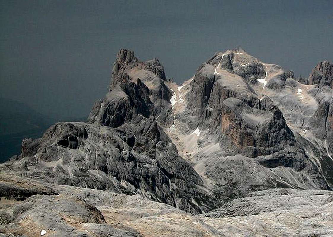 |  |
You probably disagree with me but this was not the perfect lookout peak I had hoped for. Too much obstruction and the thickest of hazes left me a bit disappointed. But imagine this on a clear day !
Monte AgnerLastei d' AgnerSass de le CaureSass de le SnareCima de la BetaCroda GrandeCima ManstornaCima del CoroCima dei LasteiSass d'Ortiga
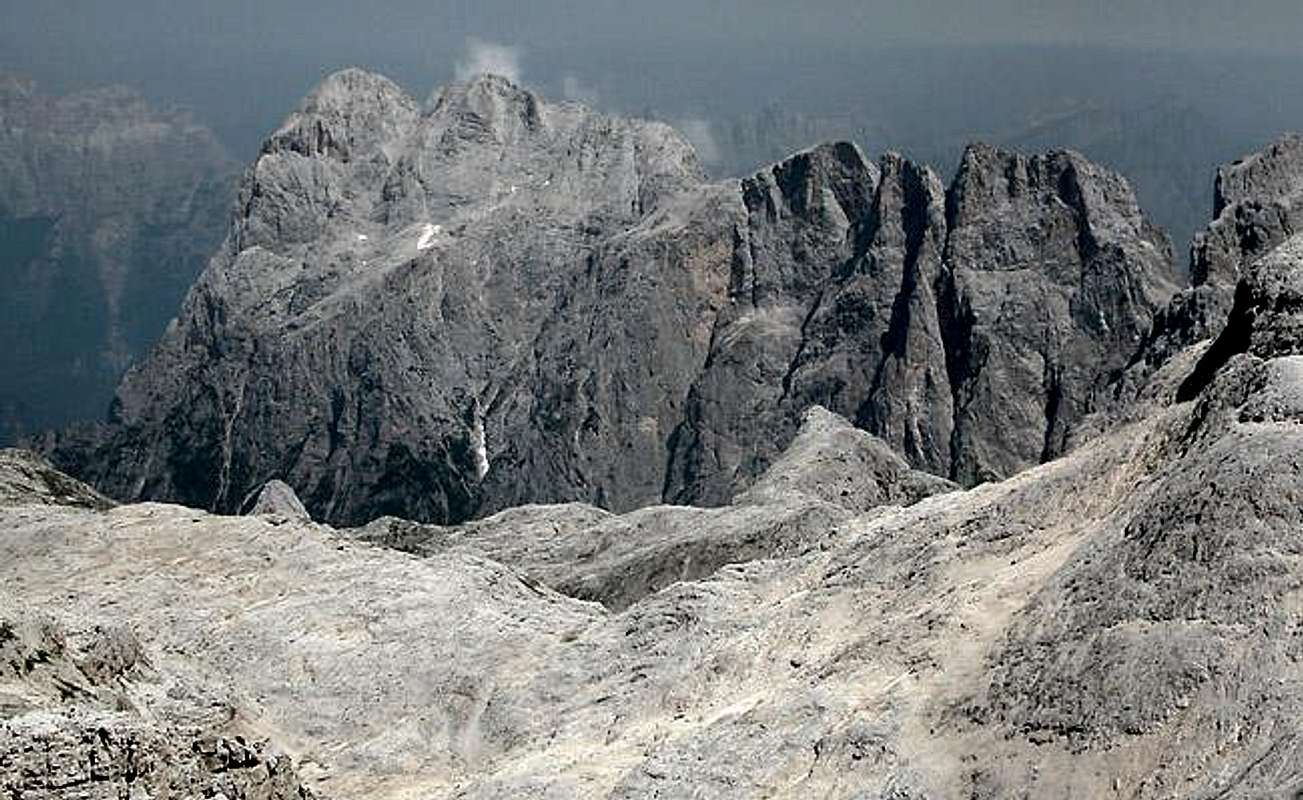 |  |
The Altipiano delle Pale di San Martino

The Altipiano as seen from the summit of La Fradusta. Hard to tell the size here. Compare the glacier with the sig pic. It's the lower one...
In many respects Cima della Fradusta is the perfect mountain to experience the Altipiano. Regardless where you come from you'll have to hike a long way across the uneven plain. The barrenness is fascinating but what got to me most was the sheer size of that area. Also, in the hot conditions of our ascent day it was blindingly light on the Altipiano.
And naturally Fradusta is the place to sit and wonder about the whole size of the plateau. Everything is on display. It makes you wonder that there are so many lakes - usually karst plains like this drain very rapidly into underground caves. This seems to be different here.
 |  |  |
Getting There
Being located at the centre of the Pale di San Martino Group Cima della Fradusta can be reached from everywhere. The most logical starting point is the cable car station at Cima della Rosetta. From there the crossing of the Altipiano is long and tedious but you will have to cover only 800m of elevation.
The next best sarting point would be Rifugio Pradidali to the south-west of La Fradusta with a 1000m elevation difference while Rifugio Treviso in Canali to the south-east is already 1300m lower than the summit.
For diehard Altipiano lovers like myself I can recommend a long loop from Rifugio Rosetta to Forca del Miel to Passo Canali to Cima Fradusta and back via Passo Fradusta and Passo Pradidali. You'll be gone for 8 - 9h and 1500m of elevation difference. But you'll be able to see all the major mountains of the Pale di San Martino Group in one day.
The following itineraries describe how to reach San Martino di Castrozza (starting point of the Rosetta cable car). The Rifugi Pradidali and Canali can be best reached from Fiera di Primiero south of San Martino.
- Motorway A13 (Bologna-Padova) exit Padova South or Padova West;
SS47 della Valsugana (in the direction of Bassano/Trento) up to Cismon del Grappa;
SS50bis (in the direction of Feltre/Belluno) up to Arten;
SS50 to San Martino
- Motorway A4 (Torino-Trieste) up to Vicenza and motorway A31(Vicenza-Valdastico) exit Dueville;
SS47 della Valsugana (in the direction of Bassano/Trento) up to Cismon del Grappa;
SS50bis (in the direction Feltre/Belluno) up to Arten;
SS50 to San Martino
- Motorway A22 (Modena-Verona-Brennero) exit Trento center;
SS47 della Valsugana (in the direction Bassano/Padova) up to Cismon del Grappa;
SS50bis (in the direction of Feltre/Belluno) up to Arten;
SS50 to San Martino
- Motorway A22 (Modena-Verona-Brennero) exit Egna-Ora (BZ);
SS48 (in the direction of Val di Fiemme - Val di Fassa) up to Predazzo;
SS50 to Passo Rolle and San Martino di Castrozza
 |  |  |
Red Tape

The desert is alive! Yellow alpine poppies growing from stone...
Cima della Fradusta and the Pale di San Martino Group are located within the park boundaries of the Parco Naturale Paneveggio - Pale di San Martino.
The Natural Park consists of the area of the Pale di San Martino Group as well as the forest of Paneveggio and the porphyritic chain of Lagorai. It contains an area of 125 sqare km which in 1987 has been divided in three different levels of protection:
33% of the area have been assigned complete protected areas,
60% are restriced areas while
7% are controlled area.
For more information you can look at the Park's official website.
There are no fees or limitations for hiking and climbing, however you might have to be prepared for small parking fees within San Martino, Fiera or at Malga Canali. The cable car parking lot is free.
When To Climb
La Fradusta can be climbed all year round. I'm not sure about the cable car in winter but tour skiing from Val Pradidali or Val Canali is possible. My map shows a tour ski route up to Fradusta's summit.
Climbing season runs from June through late September. The Altipiano gets very hot and bright in summer - it is a good idea to bring glacier goggles.
Accommodation
For Hotels and appartments have a look at the websites of the towns and villages of the region:
- San Martino di Castrozza - www.sanmartino.com
- Fiera di Primiero - www.dolomiti.it
If you are interested in the mountain huts and Refuges, just have a look at the Pale di San Martino Group Page. Rifugio Predotti, Rifugio Pradidali and Rifugio Canali are the closest ones.
Weather Conditions
For weather conditions in Trentino look at the following pages
As for Webcams you can look at
Maps & Books
Books:
- Hiking and Trekking
- Höhenwege in den Dolomiten
H. Dumler
Bruckmann Verlag
ISBN: 3 7654 3860 X
- Dolomiten
P. Fleischmann
Kompass Verlag
ISBN: 3 8705 1409 4
- Höhenwege in den Dolomiten
- Climbing
- 3000er in den Alpen - Die Normalwege
R. Goedecke
Bruckmann Verlag
ISBN: 3-7654-3661-5
- Dolomiti. Il grande libro delle vie Normale / Dolomiten. Das große Buch der Normalwege
G. Buscaini, S. Metzeltin
Zanichelli
ISBN: 88-08-09892-3 (German Edition)
- Pala Gruppe
L Visentini
Ed. Athesia
ISBN: 8 8701 4612 X (german version)
- Pale di San Martino
Luca Visentini (1990),
ed. Athesia, Bolzano
(with a handmade 1:25000 map)
ISBN 88-7014-598-0 (italian version)
- Dolomiti - Scoperta e Conquista
Hermann Frass (1976)
Ed. Athesia, Bolzano/ Bozen
ISBN 88-7014-025-3 (italian version)
- 3000er in den Alpen - Die Normalwege
Maps
- Pale di San Martino
Kompass Map WK 622
ISBN: 3 8549 1548 9
Scale: 1:25000
- Pale di San Martino
Kompass Map WK 76
ISBN: 3 8549 1086 X
Scale: 1:50000
- San Martino di Castrozza e le zone adiacenti
Carta delle zone turistiche d'Italia
Touring Club Italiano
Scale 1:50000
- Pale di San Martino
Tabacco Map 022
Scale: 1:25000