
-
 4272 Hits
-
 86.85% Score
-
 23 Votes
|
|
Mountain/Rock |
|---|---|
|
|
46.24970°N / 11.91500°E |
|
|
Veneto |
|
|
Trad Climbing |
|
|
Summer |
|
|
8760 ft / 2670 m |
|
|
Overview
Geographical classification: Eastern Alps > Dolomites > Pale di San Martino > Cima del Coro
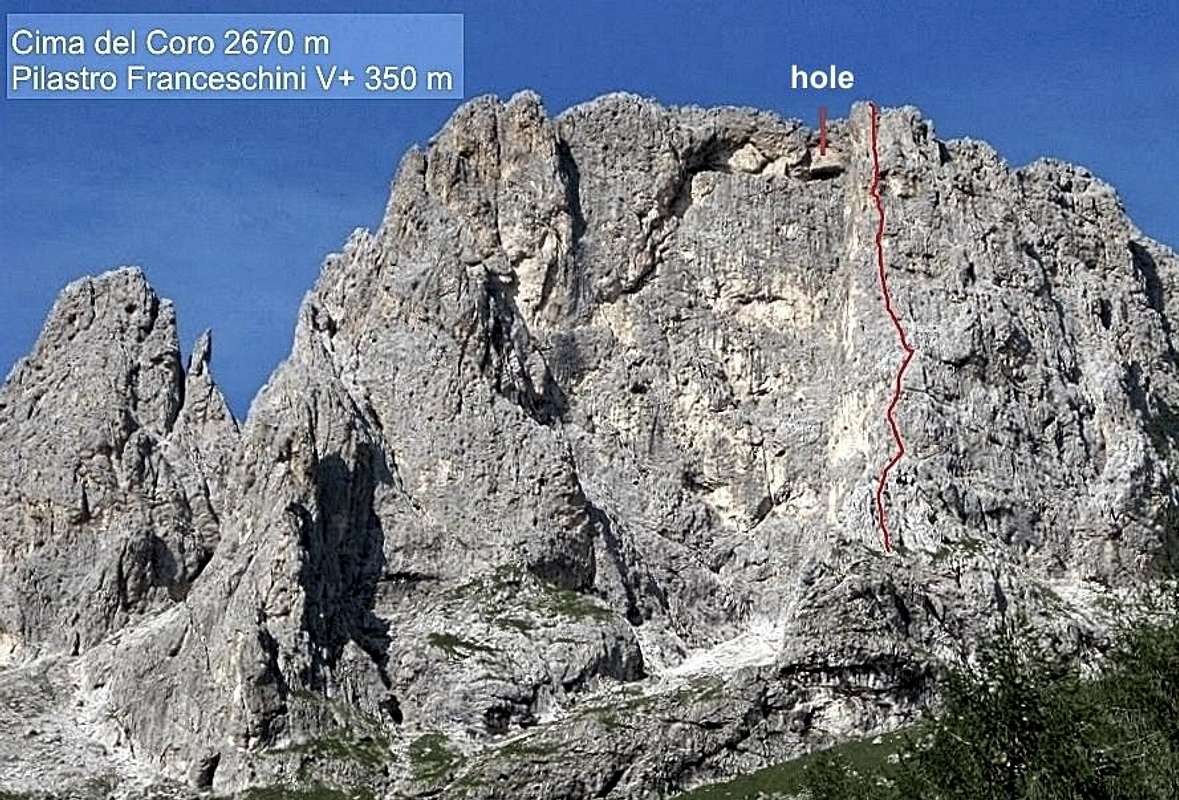
Cima del Coro 2670 m
In the Eastern sector of Pale di San Martino is located the Subgroup of Marmor, a small chain arch-shaped including some peaks, among which the most famous and frequented is the superb Cima del Coro, dominating the head of the upper Val Canali with its wide and majestic Southwest wall, the finest wall to climb up. The opposite side facing North-East dominates the small glacier Marmor, now almost extinct. The wall has several interesting routes, some of which very repeated despite the location of the peak, involving a rather long approach.

The summit of the mountain is shaped by a long jagged crest oriented in the South-East / North-West direction. The name of the mountain - Coro means chorus - derives from a unique hole in the rock wall opening onto the South-West face and allowing the passage on the opposite side: an ancient legend says that when the "tramontana" (Northern wind) comes through the hole generates a characteristic sound that recalls the echo of a chorus.

|

|
Getting There
The closest town is Fiera di Primiero.
- Coming from A22 Autobrennero exit Trento and take the Valsugana road. Follow it reaching the junction to Feltre in Primolano. At the junction leave the Valsugana road and take the road to Feltre, then follow the road to Fiera di Primiero. In Fiera di Primiero take the road to Passo Cereda, shortly before this proceed towards Val Canali and reach the Rifugio Treviso parking where the road ends.
- Coming from A4 Milano-Venezia Motorway exit Padova West, reach Bassano del Grappa, take the Valsugana road to the junction towards Feltre in Primolano. In Primolano leave the Valsugana road and carry on as described in the previous chapter.

|

|
Walking approach to Rifugio Treviso
From the parking follow the good wide track which enters Val Canali. The wide track becomes a path and afters some hairpins inside the wood reachs Rifugio Treviso (50 minutes from the parking).
Pilastro Franceschini report
Cima del Coro South-West Wall – Pilastro Franceschini report (UIAA scale)
Summit altitude: m 2670
Difficulty: Alpine D+, UIAA max V+
Route length: 350 m
Exposure: South -West
First ascent: Gabriele Franceschini – A. Bianchini 1944, august
Starting point: Cant del Gal or Rifugio Treviso
A fine classic climb on excellent carved dolomia up a stuning pillar on the SW face of the peak.

|

|

|
Approach from Rifugio Treviso
From the shelter take the path n. 707 rising towards Passo Canali in upper Val Canali and leading to a fork (signposts). Take the branch to Bivacco Reali and Via Ferrata Fiamme Gialle, entering the amphitheater below Cima del Coro SW wall.
The starting point of the route is a chimney situated a bit to the right of the pillar edge
L1 - Climb all the easy chimney, then goo up the ramp debris reaching the base of the second chimney and belay on its left (2 pegs) III+, 35 m
L2 - Climb the second chimney which in its upper part becomes a gully (peg and hole) III+, 25 m.
L3 - From the bealy move a couple of meters towards right to keep a wall cut by some thin cracks. Climb it, then follow easier rocks to the belay (peg and hole) IV+, V+, IV, 30 m.
L4 - On easier ground climb up reaching a good stance (2 holes) III, 40 m.
L5 - Climb directly the wall above the stance keeping a crack. Belay to be equipped. III+, 45 m.
L6 - Climb up on the left of the overhanging band, then directly to a stance at the base of a chimney (peg and hole) III, IV-, 30 m.
L7 - Up the chimney and then slightly to the right to overcome an overhang. Belay on the left (sling) IV, 40 m
L8 - To the right of the stance heading towards the overhangs above, reaching a terrace, from which the overhangs must be avoided on the left. Belay on a small terrace (hole) IV, IV+, 35 m.
L9 - Up an overhang on the left of the stance, then return right. On easier ground to the base of the upper slanting right crack. Belay on the left at the base of the crack (2 pegs) IV+, IV, 50 m..
L10 - Up the crack and belay a few meters below the summit of the pillar (holes) IV+, 45 m.

|

|
Descent
It's possible to abseil down the same route, alternatively by following the standard route on the N side. From the top of the pillar a 45 meters abseil leads on a ledge (cairn) that cuts the South-West wall. From here traverse left and climb up the easy rocks (exposed) to the hole that allows you to switch on the Northern side. Past the hole, on the left, you can reach the summit of the peak (red marks); going instead to the right you will begin the descent. Follow the path to the first abseil anchor (20 Mt). Then take the left fork (upstream face) to reach the next berth. Make 3 fell along the channel (20 - 25 - 30 Mt) and then follow the cairns and red marks (exposed - steps II) until it reaches the strike "yellow flame" that runs downhill until it ends. Now follow the path down into the channel (red stamps) to the point where it had left to reach the attack. From here, back to the same path during the approach, it's back to the refuge Treviso and then to the parking lot.

|

|
SW wall other routes
- Via Andrich - Timillero - Via Gadenz - Via del Diedro - Via Barbier-Timillero
Red Tape
No particular restrictions in climbing and hiking. Cima del Coro is located inside a wild and preserved setting.
Natural Parks
Cima del Coro is located inside Pale di San Martino group. This area, shared between the provinces of Belluno and Trento, is one of the nine mountain systems of the Dolomites acknowledged as UNESCO World Heritage Site.
More info about here:
Dolomites living mountains by Silvia Mazzani on Summitpost
Unesco World Heritage
When to Climb
SW wall of Cima del Corso is a sunny setting, anyhow the descent involves downclimbing on the North side of the peak. Best period goes from middle June to middle September.
Hut

Other accomodation:
- Malga Canali 1302 m
Meteo
ARPAV Dolomiti Meteo
Dolomiti Meteo Veneto
ARPAV DOLOMITI METEO Phone +390436780007 fax +390436780008
CENTRO VALANGHE DI ARABBA Phone +390436755711 fax 043679319 e-mail cva@arpa.veneto.it
Meteo Trentino
Dolomiti Meteo Trentino
Guidebooks and Maps

"Pale di San Martino" - Samuele Scalet and co. - Edizioni Versante Sud