
-
 19395 Hits
-
 74% Score
-
 4 Votes
|
|
Mountain/Rock |
|---|---|
|
|
6.89373°S / 108.40697°E |
|
|
Hiking, Mountaineering |
|
|
10098 ft / 3078 m |
|
|
Information on the trek to Mt. Sirung on Pantar Island
Overview
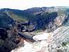
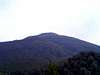
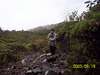
Gunung Ciremai, also known as Cereme, is the highest mountain in the province of West Java. It lies about 50 km to the south-west of the city of Cirebon. It is a stratovolcano. What stands out most about this mountain is the 1-km-wide and 500-m-deep crater. At the moment Ciremai is dormant. The last eruption took place in 1805. Many people climb this volcano, especially Indonesians. The ascent is a walk-up through mountain rain forest, which noticeably changes with the altitude. The paths are divided into several sections. After each section there is a small, signposted clearing, called "pos".
 |  |  |
Getting There
By air: International airport: Jakarta Nearest domestic airport: Bandung By bus: To Cirebon there are bus services from Jakarta, Bandung and Surabaya. By train: Cirebon lies on the railway line from Jakarta to Surabaya and on to Banyuwangi (the ferry port to Bali), a route used by many travellers on their way from the capital to Bali.
Routes
There are three routes to the top: from Linggarjati, from Palutungan, and from Apuy. The most often used route is the one from Linggarjati. Another route is from Palutungan. It is the longest route and is very time-consuming. The third route is from Apuy. This is the shortest track but the most exhausting. You find water only along the second route. The three tracks are well marked and there are lots of so-called "pos" for camping. 1. Linggarjati: From Cirebon, take a bus to Kuningan and get off at Linggarjati. From the bus stop walk to Linggarjati Museum (Linggarjati is a historic place, where negotiations were held between the Dutch and the Indonesians in 1946, before full independence was achieved). There you will find hotels and guesthouses. The trailhead is very close. The ascent from Linggarjati takes about 8 hours. 2. Palutungan: From Cirebon, take a microbus to Cisanatana, and from there, a pick-up to Palutungan. 3. Apuy: From Cirebon, take a bus to Maja, and from there, a pick-up to Apuy. This route is on the west flank. You can go up from Apuy and descend to Linggarjati. The crater rim is sometimes so narrow that you cannot walk on it but have to make a detour through the thicket. (For a detailed description of the route from Apuy, see the "Routes" section.)
 |
Camping
You can put up a tent at any of the "pos" but there is usually no water.
Red Tape
You have to pay a small entrance fee (for each route).
When To Climb
June - September Climate
Mountain Conditions
For volcanic activity check the reports published in the Global Volcanism Program by the National Museum of Natural History, Smithsonian Institution - Cereme. Weather
External Links
MERBABU:COM - MT. CIREMEI Text + photos Global Volcanism Program By the National Museum of Natural History, Smithsonian Institution You may also be interested in climbing Mt. Sirung on Pantar Island.