
|
|
Mountain/Rock |
|---|---|
|
|
3.17193°N / 98.39077°E |
|
|
Hiking, Scrambling |
|
|
Spring, Summer, Fall, Winter |
|
|
8071 ft / 2460 m |
|
|
Overview
Gunung Sinabung is an active volcano located in the Karo Highlands of Northern Sumatra. At 2460m it is the highest of the area and likely the hardest to climb. The peak is significantly harder to climb than nearby Gunung Sibayak which is popular with tourists and locals alike. Compared to Sibayak the forested slopes of Sinabung are more pristine, the summit views more dramatic and the climb more varied.There is only one route to the summit that I know of and everybody takes the path that starts at Lake Kawar to the North of the volcano. The climb involves around 1000m of ascent in a single day and sections of the climb involve scrambling. Typically the roundtrip takes 6-8 hours. The lower portion of the route is through dense forest while the final third involves scrambling up a narrow strip of lava flow which is particularly fun. Many people take a local guide although the route is obvious once you have found the tiny trailhead. The route is described on Summitpost here.
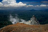
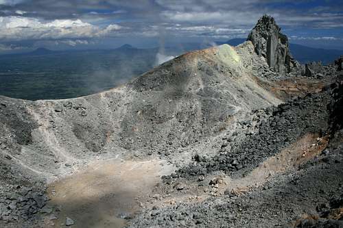 Gunung Sinabung's summit crater
Getting There
 Berastagi
The mountain can easily be reached from Berastagi, a fairly popular traveller’s haunt due to local volcanoes and Batak culture. Berastagi is around 2 hours travel from Medan, the largest city in Sumatra and third largest in Indonesia. Medan’s airport is well connected to other cities in Sumatra and Java, also Kuala Lumpur and Pinang in Malaysia.
The following airlines also have regional flights to Medan:
AirAsia Flights to Medan from KL, Penang and Jakarta
Garuda Flights to Medan from Kuala Lumpur and Jakarta
Lion Air Flights to Medan from Penang and Singapore
Malaysian Airlines Flights to Medan from KL, Penang
Silk Air Flights to Medan from Singapore
Sriwijaya Flights to Medan from Penang, Singapore and Jakarta
Note that schedules regularly change, airlines go out of business and new ones start up.
Buses depart for Berastagi from Medan’s Pinang Baris bus terminal which is 10km west of the city centre. Transport is frequent and finding the right bus or minibus is easy.
From Berastagi there are opelets (small minivans with two benches in the rear for passengers) to Lake Kawar that leave throughout the day. The yard that they depart from is on the Northern side of the bus station but just ask bus companies and you will be pointed in the right direction. The journey to the Lake is only 24km although how long this takes depends on how many deliveries the driver has to do and detours are not uncommon.
Red Tape
There is a fee of Rs2000 per person to climb the peak (about $0.20). This is collected by locals.Most nationalities require a visa however most can obtain a 30 visa on arrival at Medan’s airport or seaport. Two month visas can be applied for in advance by most nationalities. Check with you local Indonesian embassy.
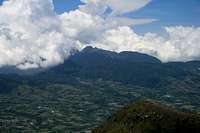
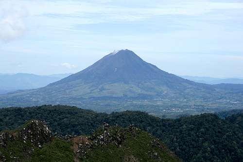 Gunung Sinabung viewed from neighbouring Gunung Sibayak
Camping and Accommodation
There is a campsite at Lake Kawar (1400m) with beautiful surroundings although in close proximity to village homes. You can reportedly stay with locals if you ask around. Alternatively there are some pavilions on the campsite that you can sleep under if you have no tent. Bring some food and there are limited provisions on offer in the village. Also bring some earplugs as there were nearby dogs barking all night long. The guesthouse where I stayed in Berastagi reported that some people in the past have had local kids climbing in the tent whilst they were climbing Sinabung although nothing was taken. I had no problems however it would be prudent to put a small padlock on your tent. Camping at Lake Kawar is surprisingly cold at night so bring a 3 season sleeping bag rather than a cotton liner (as I did). Although camping close to water I didn’t have a major problem with mosquitoes.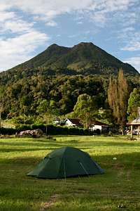 Campsite besides Lake Kawar Campsite besides Lake Kawar |
 Campsite besides Lake Kawar Campsite besides Lake Kawar |
 Lake Kawar Lake Kawar |
Mountain conditions
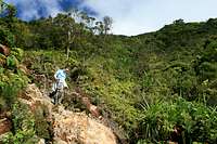
The peak is perfectly safe to climb for anybody with good fitness, confident with basic scrambling and with the commitment of a 1000m ascent brings. The peak contains a number of lava flows on its flanks although no historical eruptions have been recorded.The lower portions of the climb are particularly muddy in places and sections of the path are also eroded. After rainfall leaches will likely be a problem.
The upper portion of the climb lacks tree cover and midday temperatures can be high meaning suitable skin protection is a requirement and rehydration important.
 Climbing the lava flow Climbing the lava flow |
 Descending the lava flow Descending the lava flow |
 View to Lake Kawar from lava flow View to Lake Kawar from lava flow |
 Descending the lava flow Descending the lava flow |
Summit Views
 View South-East View South-East |
 View South View South |
 View South-West View South-West |
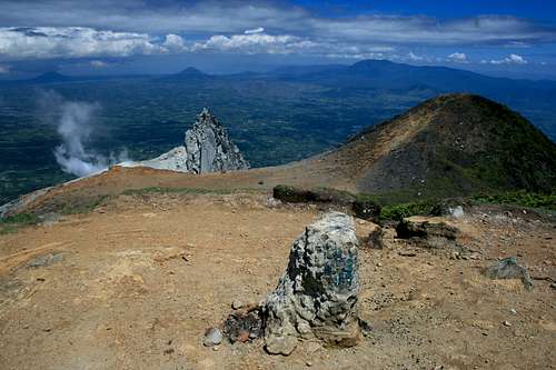 Gunung Sinabung's summit
 Summit plateau Summit plateau |
 View to Gunung Sibayak View to Gunung Sibayak |
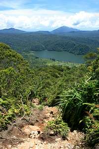
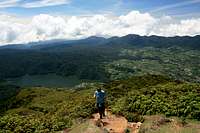 View North to Lake Kawar View North to Lake Kawar |
When to Climb
Being only 3 degrees north of the equator rain can fall anytime of the year and in significant volumes so come prepared. The dry season, which is obviously preferable, falls between May and September while the wet season falls between October and April.Weekends and public holidays are more popular with locals but few people climb this peak compared to Sibayak.
 Sinabung viewed from neighbouring Gunung Sibayak Sinabung viewed from neighbouring Gunung Sibayak |
 Sinabung from the Kutacane Road Sinabung from the Kutacane Road |
 Sinabung from the village of Lingga Sinabung from the village of Lingga |
Maps
There are are no quality maps that cover the volcano with sufficient detail to be of any use.A basic sketch map is available online here that shows the basic location of the volcano relative to Berastagi. There is also a basic sketch map of the Karo Highlands here.
Wisma Sibayak in Berastagi also provide a free map of the area which is of similar quality.
atavist - Aug 29, 2010 8:09 pm - Hasn't voted
First activity in 400 yearsAug 30, 2010: This volcano just started spewing fumes and ash causing mass evacuation on its slopes and surrounding areas.