Overview
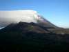
Gunung Soputan is an active volcano in the scenically very beautiful Minahasa region of North Sulawesi province, Indonesia. Its eruptions are relatively short lived (usually around a few days) and only happen at most a few time per year, so it can be climbed most of the time. Its height is given as 1784m or 1825m depending on the sources, but the latter is likely closer to the truth as Soputan has grown significantly in the last decade or so. Gunung Soputan is commonly approached from the East as its eastern surrounding are at the highest elevation and the active western slopes are prone to rockfalls as well as lava and pyroclastic flows during or after eruptions. A trip from the nearest village to the top and back can be done in two days and one night.
Getting There
The regional starting point for a trip to Gunung Soputan is the provincial capital Manado. Manado is linked by air to all major cities in Indonesia as well as Singapore and Davao in the Philippines. From Manado, take a bus or minibus for 2-3 hours to Kawangkoan (either via Tomohon or direct) and from there hire a motorcycle taxi for the last 30 minutes to the village of Toure. The trail to Soputan starts right behind the church in Toure and if required, a local guide may be hired here as well.
Route
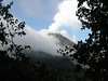
The trail to Gunung Soputan starts as a wide path out to the fields behind the church in Toure. After about an hour's walk, the path becomes narrower and enters light forest. Halfway up the hills, a sharp right turn has to be taken, off of the main path and onto the actual hiking trail. There are no signs or other indications, so this is the hardest to find part of the hike. Along the hiking trail the forest becomes denser and a small open area often used by hikers for fires is passed. A few hours into the hike, the path becomes a small stream; you have not lost the path, you just need to continue through and along the stream. Its water is not drinking water as it contains volcanic minerals (you may notice a weak sulfur odor). Eventually the path leaves the stream and climbs up a steeper part of the hills. You end up in an open pine forest that is usually used to pitch a tent for the night. A very early start (~4am) the next morning is important for a good chance of a cloud free summit. From the camping area, the trail continues across a small plateau of volcanic sand and tall grass before entering a forest and descending into the valley that still separates you from Soputan. After leaving the campground it is important to keep left. You will have your first view of the mountain from the sand plateau. After having descended to the foot of Soputan, the rest of the route is fairly obvious. One ascents the small ash cone in front of Soputan proper and then to the true summit from there. The summit has grown significantly due to eruptions during the last decade or so, and progress on the steep loose ash and scree slopes is slow, but very well worth it. Return to Toure along the same trail on the same day.
Camping
The usual overnight spot for the hike is the open pine forest reached in five or so hours from Toure village. For individual hikers or small parties of no more than three sleeping in bivouacs rather than tents, it may be possible to continue another 30 minutes along the trail and spend the night with a view of Soputan across the valley to be crossed the next morning. However, there isn't much space there and this part of the trail may be difficult to recognize in the dark without a local guide.
Red Tape
No official permits are required for this hike. You may be asked to come inside for tea and to sign the hikers book by the village head in Toure, but usually you can just show up and start the hike. Remember that Soputan is an active volcano, so it only makes sense to inquire about its current level of activity before you leave. In the case of a recent eruption without rain since, the forest close to the mountain may be difficult to traverse due to layers of ash and consequently small fallen trees. In case of an ongoing small eruption, it is still possible to go slightly past the campground and view the mountain across the valley, but climbing it would obviously not be a good idea.
When To Go
Temperatures are almost constant (hot) year round. It does get chilly at night though, so do take your sweater and sleeping bag. The driest months in North Sulawesi are July through September, so the hike would be most pleasant and the chance of a cloud free summit the highest then.
External Links
Soputan page of the Global Volcanism Program of the Smithsonian Institution
Soputan page at Volcano World