
-
 8234 Hits
-
 88.19% Score
-
 26 Votes
|
|
Mountain/Rock |
|---|---|
|
|
41.27677°N / 120.1688°W |
|
|
Modoc |
|
|
Hiking, Scrambling |
|
|
Spring, Summer, Fall |
|
|
8971 ft / 2734 m |
|
|
Overview
 Cole Peak above North Emerson Lake
Far northeast California’s Warner Mountains are a classic fault block range, having a gradual western slope rising to a crest and a sudden, dramatic eastern escarpment. Most of the range's highest points are found along the crest. Cole peak is one of only two peaks to buck this trend. Dusenberry Peak, to the north, is the only other exception. However, unlike Dusenberry Peak, which rises only 250 feet above the lowest point between it and the Warner Crest, Cole Peak towers over 700 feet above the saddle connecting it to the main crest of the range. This lends it a much higher and isolated view than many of the other summits in the Warners. Indeed, it is possibly the best location, at least in the lower southern portion of the range, from which to observe the magnificent eastern escarpment. It is also the best location from which to view massive Eagle Peak, which, from most other vantage points, seems like an unimpressive mound.
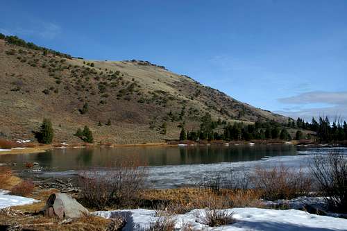
 North Emerson Lake, below Cole Peak
Cole Peak itself is not nearly as rugged as the other high peaks in the Warner Mountains. Aside from its fairly sheer eastern face, it is a high rounded knob. There are occasional extrusions of volcanic rock but these remain exceptions to the bunchgrass-covered dome that is the summit. This is not to say that Cole Peak is without outstanding features. Particularly, North Emerson Lake is found on the peak’s southern shoulder. This lake is easily the prettiest in the southern portion of the South Warner Wilderness. It rests is a stark, yet beautiful rock bound cirque, constituting the headwaters of Emerson Creek, one the South Warner Wilderness’s major watersheds. Like most of the Warner Mountains, the area’s appearance is a rather unusual mix of high desert and alpine features. Sage, bunchgrass and mountain mahogany coexist with aspens and white and lodgepole pines.
As noted previously, Cole Peak boasts outstanding views. The entire southern portion of the Warner Crest, from Dusenberry Peak to Emerson Peak is visible. Eagle Peak seems so close one can reach out and touch it. Directly below the summit is the Emerson Creek Basin to the south and Eagle Basin to the north, both being major Warner watersheds. The Surprise Valley stretches from the northern horizon to the south and beyond high peaks of the Great Basin fade off into Nevada.
Warner Mountains
 Eagle Peak and the Warner Mountains
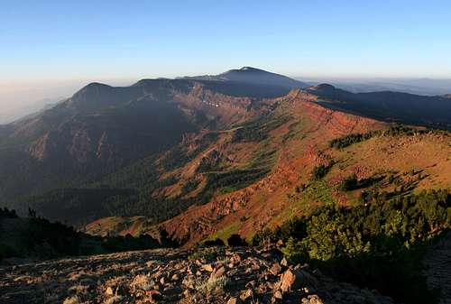
The Warner Mountains are a classic fault block mountain range. Like the Sierra Nevada and the Oregon Cascades, the Warners have a long, gradual western slope and a sheer eastern escarpment that drops off dramatically from the summit of the ranges highest peaks. Viewed from the Modoc Plateau to the west, the Warners look mild and rounded, little more than large renditions of hills found throughout northern California. However, looking east from the Surprise Valley, these mountains are rugged and foreboding.
The Warner Mountains lay to the east of the California Cascades, in eastern Modoc County. The vast tableland between the Cascades and the Warners is referred to as the Modoc Plateau. It is composed of layers of volcanic flows and periodic volcanic uplifts. Lava Beds National Monument contains the best examples of these, although numerous locations boast similar features, such as the Ahjumawi Lava Springs. Large lakes and wetlands are found throughout the region. The largest lake, Goose Lake is nearly as big as Lake Tahoe and straddles the California-Oregon state line at the foot of the Warners. The western slope of the Warners also feed the Pit River, one of California’s longest rivers and one of only three waterways to transect the Cascade Range.
 Eagle Peak from Cole Peak
Eagle and Warren Peaks are the only two summits in the range that exceed 9,000 feet, both reaching to nearly 10,000 feet. The rest of the range contains and abundance of peaks well over 8,000 feet. This is true of the portion of the range in California as well as the northern third that lies in Oregon.
The Warners are in many ways a singular and unusual range. Standing at the transition point between the Cascade Range and the Great Basin, they exhibit qualities of both regions. Sagebrush is ubiquitous, as are vast wildflower displays. In fact, the Warner Mountains boast some of the finest wildflowers in northern California. Interestingly, these characteristics lend the Warners a striking similarity with the Rockies. This is perhaps best demonstrated in the abundance of aspens and the fault-blocked appearance of the Owl Creek drainage, among other places.
Volcanic, Not Volcanoes
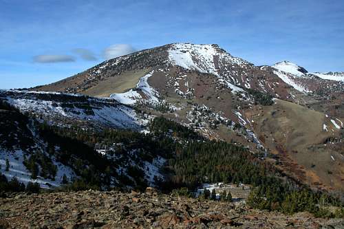
 Warner Mountains Crest from Cole Peak
While the Warner Mountains are composed of volcanic rock, they are not volcanoes. As stated previously, they are classic fault block mountains. The range is similar in composition to the Modoc Plateau to the west, which was covered by a series of successive lava flows. However, unlike the rest of the region, a massive fault uplifted, breaking apart the layers and pushing them upwards. This is visible in many areas on the eastern side of the Warners, but the cliffs above Patterson Lake are one of the best examples of this. Layers of at least 11 lava flows can be seen accreted together in the cliffs.
East of the Warners is Surprise Valley, a rift valley created by the fault uplifting. The valley is split between California and Nevada. The mountains on the eastern, Nevada side of the valley are not nearly as impressive as the Warners. Surprise Valley is home to the large but often-dry Upper, Middle and Lower Alkali Lakes. The small communities of Cedarville (the largest), Fort Bidwell, Lake City and Eagle all support agrarian communities.
South Warner Wilderness
 Emerson Peak and North Emerson Lake in the South Warner Wilderness
One of the 1964 Wilderness Act’s freshman class, the South Warner Wilderness remains one of California’s most remote and least visited wilderness areas. The wilderness is found at the southern end of the Warner Mountains and is the only wilderness area in the range. Containing 70,614 acres in an area 18 miles long and 8 miles wide. 10 lakes are found in the wilderness, though Patterson Lake is the largest, prettiest and attracts the most attention, scant as it is.
Nearly 100 miles of trail penetrate the wilderness. The highlight of these is Warner Summit Trail, which traverses the highest portions of the wilderness. Combining this trail with the Squaw Peak and Owl Creek Trails creates a spectacular 45 mile loop that travels above top of the range and then passes below the crest rim through the rugged, eastern drainage basins. Most of the lakes are passed and the highest peaks are close to the Summit Trail. Few venture into the wilderness. Most who do are locals or shepherds, the preponderance of whom seem to be from Peru.
Getting There
 Emerson Creek Drainage
From the intersection of Highways 299 and 395 in Alturas, continue east on Highway395. 5.5 miles from the intersection, veer right onto Highway 299. This road will climb through the Warner Mountains, crossing over Cedar Pass, which has particularly good views of Warren and Squaw Peaks to the south. After descending into the town of Cedarville, turn right onto County Highway 1. Continue south, passing through the small town of Eagleville. 1.3 miles after passing through the town veer right onto Emerson Road. The pavement swiftly fades, but the road is easily traveled by sedans, unless particularly muddy. Stay on Emerson Road for three miles until it dead-ends at the Forest Service campground. The trailhead is west of the campground.
Red Tape
 Cole Peak summit
Cole Peak is located in the South Warner Wilderness. Normal wilderness rules and ethics apply.
Modoc National Forest provides an excellent map for the South Warner Wilderness
Grazing is permitted in the Warner Mountains, so it is possible to see sheep or cattle. Because of this, it is a good idea to filter water.
Modoc National Forest
800 West 12th Street
Alturas, CA 96101
(530) 233-5811
Warner Mountain Ranger District
PO Box 220
Cedarville, CA 96104
(530) 279-6116
Camping
 North Emerson Lake
The nearest campground is found at the trailhead, alongside Emerson Creek in a grove of aspens. Backcountry camping is best at North Emerson Lake, about 1,200 feet below the summit of Cole Peak. This makes an excellent fishing destination in its own right, as well as a good basecamp for trips up Cole Peak and Eagle Peak. It is also a good camp for those doing the Owl Creek-Summit Trail loop. Camping is also good in the meadows in Eagle Basin, although this requires climbing to Cole Saddle and then descending into the basin. Since this area lakes any lakes, North Emerson Lake is a much preferable option.