
-
 6549 Hits
-
 83.1% Score
-
 16 Votes
|
|
Mountain/Rock |
|---|---|
|
|
41.39680°N / 120.2118°W |
|
|
Modoc |
|
|
Hiking |
|
|
Summer, Fall |
|
|
8298 ft / 2529 m |
|
|
Overview
 "Cottonwood Butte" viewed from the Squaw Peak Trail
The Warner Mountains, one of California’s remotest mountain areas, is a classic fault-block range. Running along a north-south fault line, the range has a long, gradual slope on its west side and a striking, rugged eastern escarpment. Nowhere is that more in evidence than in the South Warner Wilderness, part of the southernmost third of the Warner Mountains. The highest, most dramatic peaks are found along the crest of the range, at the apex between the gradual slope and the series of terraced cliffs that constitute the eastern escarpment. However, below the crest, there are several lower but equally ragged peaks that are generally overlooked by the few who venture into the wild lands of California’s northeast corner. The northern half of the wilderness claims two of the more prominent of these lower peaks; Devil’s Thumb and “Cottonwood Butte”. While the Devil’s Thumb is difficult to climb due to the poor quality of its rock, “Cottonwood Butte” is easily climbed via a quick scamper off of the Squaw Peak Trail.
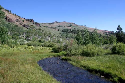 Squaw Peak and Cottonwood Creek, seen from near the base of "Cottonwood Butte"
Although unofficially named, Peak 8298 is often referred to as “Cottonwood Butte”. This is due to the peaks astounding presence high above Cottonwood Meadow. The meadow is located in a large basin nestled at the feet Warren Peak, Squaw Peak and “Cottonwood Butte”. Although the awesome, lower cliffs of Warren Peak are a spectacular presence above the meadow, the summit is out of view. To the south, a long grassy slope climbs to the summit of Squaw Peak. Despite being a couple hundred feet shorter than Squaw Peak, “Cottonwood Butte” has a much more commanding presence. This is a consequence of the peak’s 1,000 foot cliff soaring high above the meadow. Those on the epic Warner Summit Trail or using the Squaw Peak Trail to reach Patterson Lake sometimes use Cottonwood Meadow as a campsite. The site is particularly memorable. Surrounded by the cliffs of Warren Peak and “Cottonwood Butte” and the turret of Squaw Peak, Cottonwood Creek crashes down the rocky wall and then meanders serenely through the aspen lined, wildflower filled meadow. This is paradise found.
 "Cottonwood Butte" viewed from high on the Squaw Peak Trail
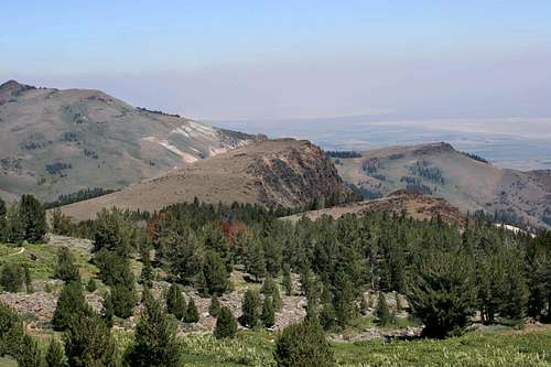
The butte is a large volcanic dome protruding from the main bulk of the Warner crest. The north and eastern sides are sheer drop offs, indicative of the fact that “Cottonwood Butte” is part of the Warner’s rugged eastern escarpment. The western and southern sides descend more gradually and consist of barren, grassy slopes. Aside from the verdant Cottonwood Meadows found at the foot of the butte’s northern cliffs, a smaller yet still lush meadow graces the foot of the butte’s western slope. A small creek that feeds into Cottonwood Creek drains this meadow. The views from the summit are great, taking in the grand cliffs of Warren Peak, the Warner crest, Squaw Peak and the Surprise Valley. The Alkali Lakes (often dry) fill the valley nearly 4,000 feet below the summit of “Cottonwood Butte”. Beyond the Surprise Valley rise the seemingly endless braids of Great Basin mountains in Nevada.
South Warner Wilderness
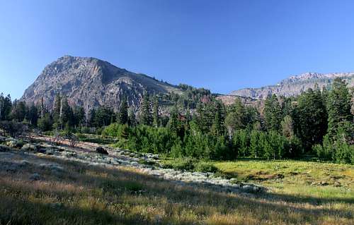
 "Cottonwood Butte" seen below Warren Peak in the South Warner Wilderness
One of the 1964 Wilderness Act’s freshman class, the South Warner Wilderness remains one of California’s most remote and least visited wilderness areas. The wilderness is found at the southern end of the Warner Mountains and is the only wilderness area in the range. Containing 70,614 in an area 18 miles long and 8 miles wide. 10 lakes are found in the wilderness, though Patterson Lake is the largest, prettiest and attracts the most attention, scant as it is.
Nearly 100 miles of trail penetrate the wilderness. The highlight of these is Warner Crest Trail, which traverses the highest portions of the wilderness. Combining this trail with the Squaw Peak and Owl Creek Trails creates a spectacular 45 mile loop that travels above top of the range and then passes below the crest rim through the rugged, eastern drainage basins. Most of the lakes are passed and the highest peaks are close to the Crest Trail. Few venture into the wilderness. Most who do are locals or shepherds, the preponderance of whom seem to be from Peru.
Route
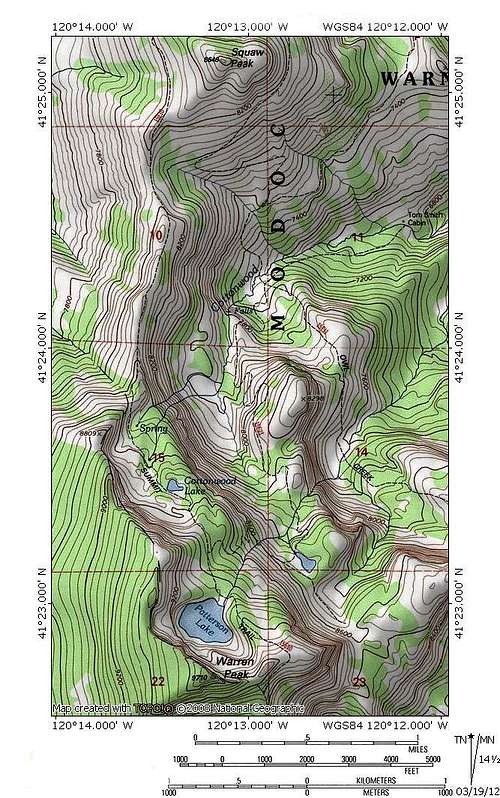
"Cottonwood Butte" is accessed via a scramble off of the Squaw Peak Trail. Details on the trail can be found here."Cottonwood Butte" Area Map
Getting There
 "Cottonwood Butte" in the South Warner Wilderness
From the junction of Highway 299 and Highway 395 in Alturas, head south on Highway 395. At the south end of downtown, turn left (east) on County Road 56, which is also named E. McDowell. The road winds for several miles, climbing up to a levee and passing a reservation casino before dropping into a shallow canyon. Views of the west slope of the Warners are excellent. Eagle, Warren and Squaw Peaks are prominently visible. Eventually the road enters Modoc National Forest and becomes Forest Road 31. Although the pavement ends the road is in excellent condition and is passable by sedans. After climbing a few more miles through the forest turn right onto Forest Road 42N79. Look for signs marking Pepperdine Camp. Do not turn left to go to the horse camp but continue straight a short distance to the parking lot at the marked trailhead.
When To Go
 Squaw Peak and the Warner crest viewed from "Cottonwood Butte"
Summer has spectacular wildflower displays throughout the Warners. October is also an excellent time to go, since the abundance of aspens means awesome fall colors. Many creeks flow year-round, but the presence of lakes assures the availability of water. The Warner Mountains is often buried in snow until mid-June. The hiking season generally lasts from then until October. The road to Pepperdine Camp is not plowed and impassable in winter. Access is difficult before the temperatures increase.
Current Conditions
NOAA Forecast for the "Cottonwood Butte" area.
Red Tape
 "Cottonwood Butte" and the lower cliffs of Warren Peak
"Cottonwood Butte" is located in the South Warner Wilderness. Normal wilderness rules and ethics apply.
Modoc National Forest provides an excellent map for the South Warner Wilderness
Grazing is permitted in the Warner Mountains, so it is possible to see sheep or cattle. Because of this, it is a good idea to filter water.
Modoc National Forest
800 West 12th Street
Alturas, CA 96101
(530) 233-5811
Warner Mountain Ranger District
PO Box 220
Cedarville, CA 96104
(530) 279-6116