
-
 11692 Hits
-
 85.87% Score
-
 21 Votes
|
|
Mountain/Rock |
|---|---|
|
|
41.93472°N / 120.22528°W |
|
|
Modoc |
|
|
Hiking |
|
|
Spring, Summer, Fall |
|
|
8224 ft / 2507 m |
|
|
Overview
 Mount Vida summit
Mount Vida is about as remote a peak as one can possibly expect to find. Lying four miles south of the Oregon border and eleven miles west of the Nevada stateline, only the diminutive Yellow Mountain and the broad, massive, Mount Bidwell are further north and east. In keeping with its isolated position, Mount Vida does not present a particularly impressive visage from most perspectives, seeming to be a high, rocky point at the crest of a long ridge. Only from the northern end of the Surprise Valley, which lies to the southeast, does the peak offer a noteworthy sight. Nonetheless, Mount Vida is one of the highest peaks in the Warner Mountains.
The geography around Mount Vida is typical of the Warner Mountains. Lower elevations have typical fir-pine forests while the higher areas have mixed lodgepole and white pines. Extensive sage and grasslands abound around the peak, interspersed between the wooded areas. Aspens are found in the drainages. Most notable of these is North Star Basin, which lies north of Mount Vida’s summit. This basin forms the headwaters of Bidwell Creek, one of the larger watersheds in the northern Warners. While no lakes are found on Mount Vida, there are two natural lakes just north of the peak. Lily and Cave Lakes are small mountain lakes just a couple miles north of the summit. Of the two, Cave Lake is more attractive and is the northernmost mountain lake in California, lying less than half a mile south of the border.
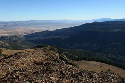 The Surprise Valley and southern Warners from the Mount Vida summit
The summit of Mount Vida is reached via the Highgrade National Recreation Trail. This trail is a closed jeep road that was initially constructed to access mining claims. Views from the summit extend deep into Nevada and include the northern Warners in Oregon, Gearhart Mountain, Mt. McLouughlin and the Mountain Lakes Wilderness, Mount Shasta and the Medicine Lake Highlands, Goose Lake and the high peaks of the South Warner Wilderness, as well as the three alkaline lakes in the Surprise Valley.
The Northern Warner Mountains
 The nothern Warner Mountains from Squaw Peak in the South Warner Wilderness
The Warner Mountains are a unique mountain range that sits at the nexus of the Great Basin and the Cascade Range. To the east, beyond the Surprise Valley, lie the seemingly endless folds of successive Great Basin mountain ranges. To the west is the Modoc Plateau, a vast wetland punctuated by occasional cinder cones and small volcanic uplifts. Though the Warners are composed of volcanic rock, they were not formed by volcanoes. Rather, they resulted from successive layers of lava flows that were ultimately thrust upwards by faulting action. These layers are characteristically visible on the rugged east side of the range. Around Mount Vida, the lava layers are most obvious on the western face of Mount Bidwell, that massive plateau that lies just east of the peak.
 Crane Mountain and the Drake Peak area from the summit of Mount Vida
There is some ambiguity about where exactly is the northern terminus of the Warner Mountains. Many believe the range ends at the Oregon border. While this does seem somewhat arbitrary, it is not entirely without reason, since the highest, most rugged and characteristic parts of the range are only in California. Namely, the only lakes to be found in the Warners are in California. More importantly, it is in California that the range’s eastern escarpment that abuts the Surprise Valley is found. This is one of the distinguishing characteristics of the Warners. Others believe the range extends far into Oregon and includes the Drake, Light and Twelve Mile Peaks area. Although these peaks are composed of similar rock as the Warners and have similar flora, they are not part of the same fault up lift. This is visible in the extension of terrain beyond these peaks to both the east and the west, lacking a dramatic escarpment so definitive of the rest of the Warner Mountains. After much discussion with Forest Service personnel, it seems the verdict is that the Warners do extend into Oregon, but terminate south of the Drake Peak area, at the valley traversed by Oregon Highway 140, the Warner Highway. This leaves Crane Mountain as the only major Warner Mountains peak that is in Oregon.
These details are relevant to Mount Vida due to its proximity to the border. If the state line was the terminus of the range, Mount Vida would be the northernmost peak on the crest of the range. Either way, Mount Vida is the northernmost peak in California that is part of the Sacramento River watershed.
Getting There
 Goose Lake from Mount Vida
From Alturas, head north on Highway 395. A little over 0.5 miles south of the Oregon border, turn right on signed Forest Road 2. After 0.5 miles, the road becomes unpaved but is in excellent condition and easily traveled by low clearance vehicles. Continue east for 5.1 miles to a signed intersection for Consolidated Mines. To reach Lily and Cave Lakes continue straight 0.5 and 1 miles respectively. To continue to the trailhead, turn right at the intersection. The road continues another 2.6 steep miles to the trailhead. While all but the very end of the road should be passable by low clearance vehicles, those concerned about their cars should park at the intersection and make the hike up the road. For those headed to the trailhead, continue south, climbing steeply. At 1.1 miles, stay to the left at a junction and another 0.6 miles stay to the right. Stay left at one more junction, another 0.4 miles further. The road continues another 0.5 miles from the trailhead. However, about 0.25 miles before the trailhead, the road breaks out of the forest and traverses a steep slope. It is highly recommended that one park at the base of the slope if there is any kind of moisture on the ground. Although the road may seem solid, the dirt can be incredibly muddy and slippery. Even in a high clearance 4x4, the mud can be too slippery and the danger of sliding off the road and highcentering on the steep slope is very real (this admonition is based on personnel experience). At the top of the slope is a large saddle with a flat parking area. The signed trailhead for the Highgrade Trail is another 0.25 miles south. Just walk the last bit of road to the trailhead.
Camping
 Lily Lake
Dispersed camping is permitted throughout the area. However, two nice campgrounds are located a few miles away from the trailhead, at Lily and Cave Lakes. Lily Lake Campground is right on the shores of the lake. However, Cave Lake is the more attractive lake. The Cave Lake Campground is locate just above the lake along its year-round inlet creek. Unless one desire to fish, this is the nicer area to camp. Neither receive much visit and are amongst the most remote campgrounds in California.
Red Tape
 Mount Bidwell and North Star Basin
While the area around Mount Vida is wild, it lacks official wilderness designation. Roads still exist in the area and there are still some mining claims, particularly to the northeast and in North Star Basin. In spite of this, normal wilderness rules and ethics should still be applied to the area.
Modoc National Forest
800 West 12th Street
Alturas, CA 96101
(530) 233-5811
Warner Mountain Ranger Station
PO Box 220
Cedarville, CA 96104
(530) 279-6116