Trip Summary
Date: August 12, 2011
Location: Salt Lake County, Utah (Twin Peaks Wilderness)
Start: Broads Fork Trailhead (6,070 ft)
Maximum Elevation: 11,330 ft
End: Alta
Difficulty: Class 4 scrambling (took us 14 hours!)
Distance: approx. 14 miles
Personnel: Luke, Billie, Kirk
Peaks:
Broad Fork Twin Peaks - 11,330 ft
Sunrise Peak - 11,275 ft
Dromedary - 11,107
Peak 11,033 - 11,033 ft
Monte Cristo - 11,132 ft
Mount Superior - 11,050 ft
Trip Report
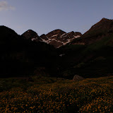
We dropped a car off at Alta in Little Cottonwood Canyon, drove down and over to Big Cottonwood Canyon and started hiking at 5:15 am at the Broads Fork Trailhead. The trail was easy to follow for the most part all the way up to the second meadow where a small pond is located amongst beautiful wild flowers. We arrived at the second meadow (2 miles) around sunrise and watched a cow moose swim across the pond! Luckily, she didn't seem to have any calves nearby. The day was starting off nicely.
After another mile up, we had to scramble and navigate the remaining ice/snow in the cirque to get to the saddle between Broads Fork Twin Peaks and Sunrise Peak. My trekking poles came in handy on the slippery, hard slope (an ice axe would have been useful). From the saddle we got a taste of what to expect all day (literally). We scrambled up, down, and across loose rocks, up and over rock walls (some low class 5 material with significant exposure), and up steep, loose couloirs to the summit of Broads Fork Twin Peaks (6.5 miles from the trailhead). From the top we could see the Salt Lake Valley and essentially all of the Wasatch Range, including the rest of our daunting task; the Cottonwood Ridge.
The peaks along the ridge looked steep and impassable, but we continued onward and back down to the saddle. I read a couple trip reports of previous hikes along the ridge and about different routes up and over these steep peaks, yet half the fun was route-finding! Sundial peak offered some challenging route-finding on the southwestern side but we made it up to the peak in 30 minutes from saddle. From there we down-climbed and scrambled down to a deep saddle and up and over to Dromedary Peak.
The ridgeline seemed unending from there. We scrambled up and down and up and down and up and down. The trip was mentally and obviously physically exhausting. It required conscious thought about each step and at least one hand for most of the ridgeline. A mistake could lead to serious injury and on some sections, a fall would be fatal. We scrambled over several unnamed peaks, including the notable Peak 11,033.
Eventually, we reached the base of Monte Cristo, which presented our largest challenge. We were closing in on 10 hours hiking time (3 pm) in the heat of the day and the mountain required some seriously exposed free-climbing. Luke led the way and we followed, despite the 1,000 ft plus drop-off below. After about 20 meters of exposed vertical climbing, we found a couloir on the southwestern side which allowed us to scramble to the peak. We met a BYU professor on the top, the only other hiker we saw all day. He took a few pictures for us and we were on our way to Mount Superior, eager to finish our hike. Mount Superior is only a hop, skip and a jump to the east so we quickly scrambled over and began to make our way down the ridge to the east. Eventually we found a trail which led us down 3 grueling miles to Alta in Little Cottonwood Canyon where we parked a car there in the dark of the early morning. By the time we reached the car, it was 7:15 pm - 14 hours exactly of hiking, 6+ 11,000 ft peaks and sore feet. It was a beautiful and very challenging adventure.
*This hike is for expert hikers who have huge amounts of endurance and can handle large amounts of exposure. Do not underestimate this hike. I brought 5 liters of water and I ran out so be prepared.
Comments
No comments posted yet.