
|
|
Route |
|---|---|
|
|
39.39700°N / 106.1°W |
|
|
Mountaineering, Skiing |
|
|
Spring, Winter |
|
|
Most of a day |
|
|
Moderate Snow / III D10 R2 (Ski) |
|
|
III |
|
|
Overview
Colorado has no shortage of snow climbs. Like any geographical area fortunate enough to be blessed with mountainous terrain, Colorado has couloirs aplenty ranging from decent beginner snow climbs (Angel of Shavano, Cristo, Lost Rat) to more expert choices like: The Refrigerator and Naked Lady.
The Monte Cristo, or just Cristo for short, is an easy to moderate couloir and widely considered to be one of Colorado's premier snow routes. The Cristo rings in at an impressive 2,575' long (almost 1/2 a mile) and averages between 30°-34°in pitch. Of course drifting and snow fall totals can alter this range slightly.
Some people put the length of this climb at just under a mile which, is all fine and good if you're counting the parking lot or some rando point along the access road as the start. But as far as I'm concerned, the starting point is at he bottom of the apron hence, the 1/2 mile reference mentioned above.
Regardless, ascending the Cristo and descending either the same way or down the East Ridge to make for a kind of 'Tour de Quandry', makes for a great way to ascend an ordinarily, boring mountain.
Approach
The only approach for this couloir is the Blue Lakes Trailhead:
- From Breckenridge, drive south on CO. 9 for about 8 miles. In doing so, you'll pass through the small town of Blue River (more of a loose collection of homes). Turn west (right) onto county road #850 and follow this to its end at Blue Lakes Dam, about ~2.1 miles, give or take. In the winter and spring, this road IS NOT plowed much past the initial homes after the turn-off. Due to the somewhat narrow Monte Cristo valley and the high elevation, this road typically does not melt out soon. But if dry, expect an easy dirt 2wd road.
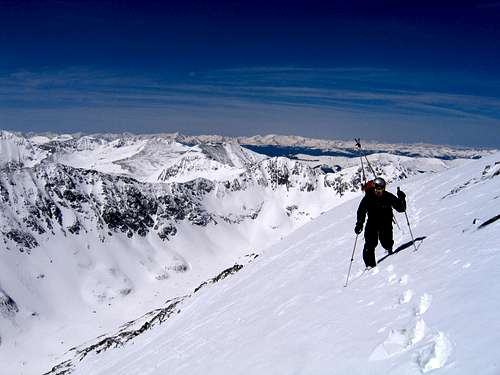
- Park at the parking lot and walk over to the north end of the dam. You'll be able to see the route from this area. At this point, simply take or follow the path of least resistance on an ascending traverse towards the couloir. On a heavy snow year, you should be able to avoid most of the willows and underbrush to attain the bottom of the apron. Gear up and get ready to climb!
Route Description
Snow Climb
Like most couloirs, the route is simple; just ascend the skyward reaching river of snow to it's exit somewhere near the top. The Cristo starts out pretty mellow (less than 30°) and takes its time in reaching the low 30° mark.
Just past 1/2 way up the couloir, the center sometimes forms a minor bulge. Obviously climbing up and over this will increase the pitch. But as a general rule, the sides of this couloir remain fairly constant. Also, near the exit which, deposits you fairly close to the true summit, the couloir widens.
And lastly, even though this line is entirely south-facing, it has been known to slide. So always be cautious.
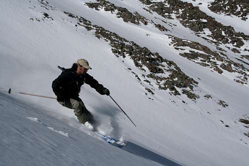
Ski Descent
This is an expert descent. Please see the avalanche information below. Obstacles will be a major concern. Late in the season, this melts out to about 13,700 feet. If a true summit descent is what you are looking for, then you might have to time this one perfectly. Luckily, most of the couloir is visible from CO 9. Lou Dawson rates this one at III D10 R2. See this link for an explanation of Lou's ski grades. Personally, I would rate this one at III D8 R3, but who am I to question Lou Dawson...
Glissade
Get ready for a wild ride. Ensure you are expert with the use of an ice axe. Be especially careful of rocks.
Summer
This route is NOT recommended for summer. It is steep, loose, and heavily eroded. Although this looks like an easy descent into Blue Lakes, it will make you sorry for your choice. Avoid this route after it melts.
Essential Gear

This should be a no-brainer, take an ice axe and crampons. These are necessary pieces of equipment. Even with years of experience and foresight, accidents can and do happen. Approach this snow climb as you would with ANY snow climb, with respect.
Choice of clothing of course, can be and for the better part, is an individual decision. But keep in mind, this is a relitively high-altitude climb, regardless of difficulty. So plan accordingly for weather and possibly, changing conditions. Also, this range of mountains is notorious for winds. So keep that in mind when packing clothing.
Avalanche Information
This face of Quandary is notorious for avalanches and injuries. In my opinion, this route is for late Spring on mature snow only. Read the information below carefully and consider the current conditions before you commit.
(All information courtesty CAIC, The Colorado Avalanche Information Center. Follow this link to the CAIC homepage. Follow the links for photos and additional information.)
Most recently, a man had to be evacuated from this face because of a serious fall in the couloir, not involving an avalanche. I couldn't find the news links, but from what I remember, the man and his wife were trying to descend Cristo without axes or crampons. The man slipped and fell into some rocks, causing serious injuries. SAR was required.
---------------------------------------------------------------------------------------
Quandary Peak:
March 24, 2005
2 climbers caught, 1 buried, and killed
At about 1220 Thursday afternoon two climbers were caught in an avalanche on the south side of Quandary Peak. One man survived with only minor injuries while his friend was buried and killed. At 14,265 feet Quandary Peak is a popular "14er" for winter climbers and skiers. Located at the south end of the Tenmile Range the summit is about 6.5 miles SSW of Breckenridge.
The two climbers -- both male -- were friends via a church group. One man -- the survivor -- was from Omaha (NE) and the other from Colorado Springs. They left at about 0830 and arrived at the Blue Lakes Dam at about 1000 hours. They pair left their snow shoes at the dam, strapped on crampons and started up the Monte Cristo Couloir which hits the summit from the south.
The pair were climbing at very different speeds. The Omaha man was climbing much faster. He remembers looking back at about 13200 feet; where the slope is a bit less steep and saw his partner below him and about 30-40 minutes behind. He waved to him motioning that he was going to continue. At about 13800’ he heard and felt a big “whumph.” The slope fractured about 30 feet above him. He instantly turned around but could not see his friend below. In the next second or two he was swept from his feet and tumbled down the entire length of the couloir. He ended up at the very toe of the debris but on the surface.
He got to his feet and not seeing or hearing his friend he set out to get help. He did not have to travel far as he was soon able to notify rescuers -- 911 -- via his cell phone from just near the dam. At about 1240 Thursday afternoon the Summit County Sheriff's Office received the call of the avalanche accident. Neither man carried avalanche rescue gear.
Rescuers from the Summit County Rescue Group, Summit County Sheriff's Office, Flight for Life helicopter, Breckenridge Ski Patrol, Copper Mountain Ski Patrol, Keystone Ski Patrol, Alpine Rescue Team, and Red, White, and Blue Fire Department responded.
The buried man was found dead at 1630 hours by an avalanche rescue dog from the Breckenridge Ski Patrol. The victim was buried under 1.15 meters of debris.
The Avalanche
Initial reports have the avalanche as a HS-AF-2+-O. This hard slab avalanche was triggered by the climbers and though it released from a large search area -- over 600 feet across -- the avalanche was small relative to the avalanche path. The fracture line was only 1 foot deep. The avalanche started at about 13,800 feet and fell to nearly 11,700 feet from a very wind-loaded (or wind-drifted) S aspect.
The CAIC Danger Rating
N mtns: ... "Front Range and Summit/Vail zones: near and above treeline on N-E-S-SW aspects the danger is CONSIDERABLE with pockets of HIGH in recently drifted lee areas. On other aspects and below treeline the danger is rated MODERATE with pockets of CONSIDERABLE on slopes steeper than 35 degrees."
Comments
At this time information is still limited but we will pass along new information as it becomes available.
Over the years Quandary Peak -- especially the south side -- has be the site of numerous avalanche and mountaineering accidents. On November 11, 2002 two climbers were caught and 1 was seriously injured when swept down the south side of the peak.
A lone backcountry skier was buried and killed on the south side of the peak on December 21, 1999.
Sawtell and Atkins
1800hrs, updated at 2130 and 2345, March 24, 2005
----------------------------------------------------------------------------
Quandary Peak
November 16, 2002
2 Climbers Caught and Injured (1 moderately and 1 seriously)
Preliminary Report
Weather and Snowpack Conditions A series of Pacific storms brought abundant snows to the Tenmile Range during late October and early November leaving a snowpack that was unusually deep and strong. However, strong northwesterly winds on November 12 and 13 caused significant blowing snow and slab formation along the Tenmile Range.
[We are collecting more weather data and will post more weather details soon.]
On the morning of the 16th triggered releases by backcountry travellers were possible on high elevation, southerly aspects. Our backcountry avalanche danger rating that day was: "N mtns & C mtns ... below TL [treeline], MODERATE on NW-E aspects steeper than 30 degrees ... on the other aspects below TL [treeline] the danger is LOW ... near and above TL [treeline], MODERATE, with pockets of CONSIDERABLE on NW-NE-SE aspects. Use extra caution in all steep terrain."
Accident Summary
On the afternoon of November 15, the two Golden men were climbing a steep, rocky gully on the south side of Quandary Peak. At 14,265 feet Quandary Peak is a popular "14er" for winter climbers and skiers. Located at the south end of the Tenmile Range the summit is about 6.5 miles SSW of Breckenridge. One man carried skis on his back; his goal was to ski from the summit while his friend hiked down. The pair started their ascent at about 10:30. About 1:30 they triggered a slab avalanche that swept them off their feet.
The skier tumbled for about 200 feet before somehow stopping. At some point during his short tumble he was knocked unconscious, and thinks he lost consciousness for about two hours. When he came to there was no sign of his friend. The skier removed his skis from his pack and used them to mark his position. Suffering bumps and bruises he started down the gully. Along the way he slipped and fell gashing his knee on either his ice ax or on a rock. He continued his slow progress toward the valley. In the fading daylight he found his friend--whom had been swept down the entire gully--on the surface. This man was seriously injured and unable to move. According to newspaper accounts the skier used extra clothes to better dress his injured friend and left him a light before striking out to get help.
The man limped his way back to the east along the valley road. After about a mile and a half he reached a home where he was able to call 911.
Rescue
An ambulance ferried the injured skier to the Summit County Medical Center. (He was later transferred to a Denver hospital.) Meanwhile the Summit County Rescue Group responded and found the injured man. He was evacuated a short distance to the road where he was put into a sled and taken by snowmobile to the highway. At this point the story of the man's survival is truly amazing. He had to be resuscitated twice, once in the ambulance and once in the helicopter. He arrived at St. Anthony Hospital in Denver with severe injuries and in severe hypothermia. Nearly a week later the man is still in the hospital, but doctors are optimistic he will make a full recovery.
When we get more details of the man's injuries and survival we will post additional information here.
Avalanche Summary
We are still awaiting a formal report, but we can surmise the men likely triggered the avalanche. No natural avalanches released that day.
Comments
The steep, rocky terrain on the south side of Quandary Peak is exciting, but in the wrong conditions it is dangerous and sometimes deadly. Over the years numerous climbing accidents and even a few avalanche accidents have occurred on the rugged slopes and gullies. Three years earlier (December 21, 1999) a solo skier was killed in a gully only a few hundred yards to the west of this accident.
In regard to this year's accident it is unknown about the mens' avalanche awareness training. They were certainly pushing their luck by climbing a very steep gully so soon after storms and winds. This time they were very, very lucky.
--------------------------------------------------------------------------------------
Quandary Peak, Colorado
December 21, 1999
1 backcountry skier caught, buried and killed
Weather and Snowpack Conditions
A very dry start to the winter (one of the driest in the past 50 years) left little snow on the high elevation slopes and gullies during November and early December. What snow that did remain--primarily on Northerly-facing terrain--turned to depth hoar.
On December 10, the Breckenridge ski area reported a paltry 16-inch base. The total seasonal snowfall had been only 34 inches, but from December 10 to 21, an additional 30 inches of new snow fell. Eighteen of those inches-accompanied by strong winds-fell from December 18 to 21. At the Breckenridge ski area the morning of the 21st dawned cloudy with light snow. The low temperature was 3° F, and the high temperature that day struggled to reach 10° F.
The recent recent strong winds and cold temperatures created widespread soft- and hard-conditions. Observers in the Northern mountains were reporting widespread collapsing and shooting cracks. Remote triggering of avalanches were not uncommon. On Monday (12/20) the Copper Mountain Ski Patrol triggered remotely a very large slab 2000 feet across and 5 feet deep on a high elevation Southeast-facing bowl while approaching the path from above.
An avalanche advisory for the Northern Mountains was issued on the evening of the 20th. A warning was not issued because widespread natural releases were not expected. On the morning of the 21st the backcountry avalanche danger rating for the Northern Mountains was rated "below treeline (TL) MODERATE; near and above TL, CONSIDERABLE, with areas of HIGH on N-SE aspects steeper than 30 degrees...triggered releases by backcountry travelers are probable to even likely on steep wind-drifted slopes and gullies." Conditions in the backcountry were ripe for triggered avalanches. The morning hotline report ended with "Be very careful in the backcountry, the Colorado mountain snow pack could easily ruin one's Christmas."
Accident Summary
On the morning of December 21, a 25-year-old Broomfield man told friends he was going backcountry skiing, but he never told them where he was headed. A few days earlier on the 19th the victim had told his sister in Illinois he was going to climb a 14er, but again he failed to say where. Friends and co-workers reported him missing on 23rd. On the 24th the Broomfield Police Department issued a state-wide missing persons report. Later on Christmas Eve his vehicle was located by the Summit County Sheriffs Office on a routine patrol at the Quandary Peak trail head parking-lot. At 14,265 feet Quandary Peak is a popular "14er" for winter climbers and skiers. Located at the south end of the Tenmile Range the summit is about 6.5 miles SSW of Breckenridge.
Rescue
On Christmas morning the Summit County Rescue Group mobilized a search effort. Five avalanches had spilled off the Southeast side of Quandary Peak, but lady luck was with searchers that morning. Very early in the operation a searcher happened across a tiny torn piece of a topographic map. Moving 100 yards further upslope he came across another small piece of a topographic map. Minutes later they spotted the victim further upslope. They found the man buried in the avalanche debris. A leg protruded from the snow. The victim had died of massive trauma.
Avalanche Summary
The accident was unwitnessed, but it appears the victim likely triggered a very small hard-slab avalanche at top of a steep, narrow gully on the Southeast side of the peak. The fracture line 1 to 2 feet thick released at an elevation of 13,400 feet. The narrow avalanche fell 1,880 vertical feet, almost reaching the valley floor. The victim was hurled down the very steep and rocky gully. He was buried by debris at the bottom of the last small cliff band about 300 vertical feet above the Blue Lakes road.
Comments
The victim frequently traveled solo in the mountains, but in this situation a partner would not have made any difference in the outcome of this accident. In fact had a partner been traveling with the victim it is likely there would have been two fatalities.
This accident could have only been prevented by better judgment. Better judgment to avoid all steep slopes during a time when very unstable snow conditions existed. The victim's level of avalanche training and/or if he had heard a CAIC report is unknown.
The traditional route up Quandary Peak is an easy ascent and descent. The route is very straight forward and avoids most dangerous avalanche slopes. Even during periods of significant avalanche danger the route can be followed with out problem with careful route selection.
We will never know exactly where the victim was when the avalanche occurred or what he was thinking prior to the avalanche.Though this accident was unwitnessed reasonable inferences can be made about what happened.
The victim was found at the bottom of a very steep and rocky gully. This gully would have been a poor ski choice even in the best of weather and stability conditions. The route is well East of the summit and has two significant cliff bands that are seldom if ever covered by snow. With the cliff bands in the gully it is very unlikely the man was trying to ascend the gully. He likely was crossing near the steep slopes above the gully when it avalanched. It is unknown if the man summited, but we doubt he did.
While it is possible the slope released naturally this scenario is unlikely. A natural release would imply the victim was low on the slope. This setting would have taken the victim far off route. Also relatively few natural releases were reported from around Summit County on the 21 and 22nd though a large cycle of natural releases did occur on the 23rd. The other four avalanches on Quandary likely ran that day. Also on the 21st and 22nd ski patrollers reported slab avalanches were easy to triggered from ski pressure. Most likely the victim triggered his own avalanche.
Both of the victim's alpine touring ski boots were stripped from his feet. Boots only come off a victim when they are worn very loose. Many people loosen their boots for ascending, but most people seldom ever wear loose boots for a descent. With loose boots it seems reasonable the victim was traversing across the top of the gully when he triggered the avalanche. Though this line of ascent would be off the established route it would not be unreasonable.
The weather on the 21st was nasty with light snow and strong winds, but visibility was okay. That day above treeline ski patrollers around Summit County reported fair visibility. Occasionally brief white-outs lasting a few seconds would obscure visibility, but landmarks along the route would have been visible and easy to follow.
To avoid the wind the victim may have purposely veered off-route to travel in the sheltered lee of the ridge. This would have placed the victim on relatively steep terrain. Foot travel would have been easy on the hard-snow. Much of this snow was relatively fresh and stable. It would have only been on this steep slope for a few weeks, so it had not had the time to weaken into faceted sugar-snow grains. But like a mine field there were pockets of older snow on the same slope that had already weakened into sugar snow. When the victim unknowingly traveled across such a pocket he triggered the hard slab and was swept down the mountain to his death.
Traveling alone in the high mountains during storms can be a very rewarding experience. It is a way to improve one's comfort level in difficult settings, but it is not a time to push one's limits. Obviously the consequences of any mistake can be severe or as they were in this case: fatal. Risk can be reduced significantly by exercising a large margin of safety. The judgment that allows us to set and operate within an appropriate margin of safety comes from experience. At times gaining experience in the high mountains can be a risky proposition. Usually when we make mistakes the mountains are forgiving and retreat home with a lesson learned. In this accident the mountains were unforgiving.

|