
|
|
Route |
|---|---|
|
|
39.39700°N / 106.1°W |
|
|
Scramble |
|
|
Half a day |
|
|
class 3 |
|
|
Approach
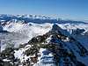
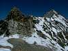
From Highway 9, turn east onto Forest Service road 850. Signs point to "Blue Lakes". The Blue Lakes trailhead is directly below and north of the upper Blue Lakes dam. Take a well-beaten use trail along the north shore of the lake, then follow it up the hanging valley to the southwest of Quandary Peak. Scramble to the northwest over class 2 rocks to the saddle between Fletcher Mountain and Quandary Peak at 13,400 feet. The Fletcher/Quandary saddle is the staging point for a side trip up Fletcher Mountain.
 |  |  |  |  |
Route Description
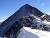
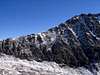
From the Fletcher/Quandary saddle, navigate through some easy class 3 scrambling until you find a use trail on the north side of Quandary's west ridge. It's sketchy in spots, but not dangerous. At 14,000 feet elevation, and a mere half mile or so from Quandary's summit, it abruptly ends, and you have to negotiate four or five steep towers to reach the summit.Maintainer's note: There is an endless discussion here about the exact route along the ridge and about the exact difficulty of the climbing. Talk to five people and you'll get five different stories. Therefore, I will try to distill all the salient facts from this conflicting information into a general strategy:
- The route-finding is NOT obvious. Even if you've done the ridge before, you WILL screw up a few times.
- Don't climb up what you can't comfortably climb down. You CAN find a class 3 route. To Gerry Roach, class 3 means, "'Hands on' scrambling." To me, class 3 means non-vertical climbing where my hands are nontheless engaged in the climbing.
- If you are about to descend into a steep, rotten gully, stop. Turn around and look for a more direct route.
- Expect some "interesting" exposure. Remember, exposure does not a class 4 climb make. A sidewalk on an exposed ridge would still be class 1, since only walking is required for upward progress.
 |  |  |  |  |
February 21, 2010. An interesting note from shaggyis18:
"Late Summer Warning
I've taken this route in late summer twice, and on both occasions came across a 6-8 foot wide sheet of snow covered ice angled at about 45 degrees spanning the width of the north side of the gully just below the 3rd tower (the first one with a large crack running vertically up it, capped off at the top by a chunk of rock). When present, this obstacle is hands down the crux of the route, so I thought it worthy of mentioning."
Essential Gear
Rope not mandatory, or even advisable under most conditions. If you choose to avoid downclimbing the West Ridge by descending the class 2 "Cristo Couloir" when it has snow, you should bring an ice axe.
Roach Says...
I was perplexed as anyone about which was the "correct" route on the West Ridge. So I e-mailed Gerry Roach, author of a popular guidebook, and asked him what the best route was. Surprisingly, and somewhat ironically, he was not 100% sure of the route that he did."This ridge is turning out to be harder than most people expect. It sounds like you missed a critical up-climb on the 4th tower. My memory is of crossing the gully, then climbing the SW face of the 4th tower (Steep but only Class 3)."
Gerry did sum it up with a general formula, however, which aptly applies to Quandary's West Ridge:
"A general rule in CO is: If it looks like Class 5 ahead, look around. There is probably a Class 3 route nearby. Few CO peak-bagging routes require Class 5 climbing. The name of the game is route finding."
DaFreshman - Aug 3, 2004 5:56 pm - Hasn't voted
Route CommentJust my 2 cents:
Did this route for the second time last weekend - now that I've had the chance to make most of the major route finding mistakes, here's my beta for the ridge:
When in doubt, go HIGH. I counted 5 distinct towers along the ride, and the easiest route appeared to go directly over the top of all but the 4th. (on #4 the route appeared to drop below a cliff on the SOUTH, then immediately turn back up to the ridge crest via a snow-filled gully.) A few of the upclimbs to the tower tops are high and exposed, but still class 3. At any rate, whenever faced with the choice of a) decend a rotten gully b)do a dicey traverse or c)climb back to the top - c is your best bet.
shaggyis18 - Sep 23, 2009 5:16 pm - Voted 7/10
Late Summer WarningI've taken this route in late summer twice, and on both occasions came across a 6-8 foot wide sheet of snow covered ice angled at about 45 degrees spanning the width of the north side of the gully just below the 3rd tower (the first one with a large crack running vertically up it, capped off at the top by a chunk of rock). When present, this obstacle is hands down the crux of the route, so I thought it worthy of mentioning.
mpbro - Feb 21, 2010 9:06 pm - Hasn't voted
Re: Late Summer Warning"When present, this obstacle is hands down the crux of the route" Boy, it sure sounds that way!
Warsteiner - Nov 13, 2013 11:41 am - Hasn't voted
Re: Late Summer WarningI'm not positive but I think this might have been where I almost lost it all last June. Climbed in late June and this was one of the only places with snow still around. Didn't have an axe or rope and the snow gave out. I ended up sliding ~30ft straight down before dumb luck led my flailing legs onto a rock straddle that just barely saved me from flying off the mountain. Were I to go again I would take an axe and a small piece of rope + pro just to safely shuttle across this snow/ice in early/late season.
mpbro - Nov 13, 2013 11:49 am - Hasn't voted
Re: Late Summer WarningHoly smoke!