
-
 5080 Hits
-
 71.06% Score
-
 1 Votes
|
|
Route |
|---|---|
|
|
46.43000°N / 13.73000°E |
|
|
Hiking, Mountaineering, Scrambling |
|
|
Summer, Fall |
|
|
Half a day |
|
|
Class 3 |
|
|
UIAA I |
|
|
Approach
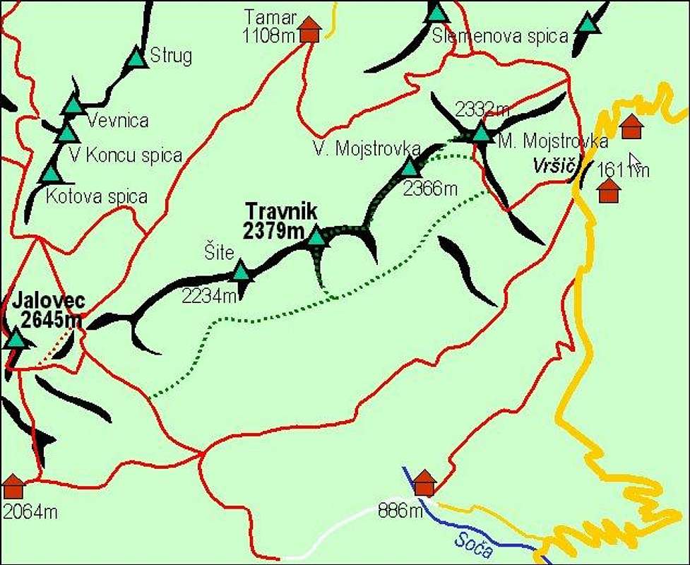
You start on Vršič Pass - see the main page.
Route Description
On the ridge from Velika towards Zadnja Mojstrovka


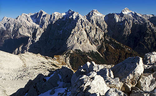
By the Southern Route you ascend Mala Mojstrovka, 2332 m. From it you continue towards the W-SW by the main ridge. First you descend a little into a saddle below Velika Mojstrovka, 2366 m, then you climb its summit. Although there is no path, the ascent is easy and short, just a scramble up. Any harder rocks are avoided on the southern side. You can ascent Velika Mojstrovka also directly, omitting Mala. While going up by the south ridge marked path on the latter, you descend some 50 meters into a shallow basin between the two and scramble from the south by steep grassy slopes and easy rocks up to the summit (here we do the skiing in winter and spring).
From Velika Mojstrovka the most beautiful part of the tour starts. You hike almost horizontally by the main ridge, high above valleys, enjoying an unsurpassable panorama. The ridge to Zadnja Mojstrovka, 2372 m, is easy, on a few places you just have to care about loose boulders. The ridge beyond Zadnja Mojstrovka to the saddle towards Travnik is sharper. It demands some easy climbing (UIAA I) and walking carefully.
Then you descend from the main ridge towards the south on the karst plateau (altitude: some 2150 m), where you perhaps find and old path going back. Even if not, walking back towards the south ridge of Mala Mojstrovka is easy - just take care in case of fog. Finally you ascend some 50 m and close the round. This option to return is fine because of the long and soft scree, which brings you later directly down on Vršič pass. Descending from Zadnja Mojstrovka, and reaching the karst terrace, you might also want to search for a hunters path, descending all the way down to the marked path, which crosses Velika Dnina slopes on the altitude of some 1700 m. When you reach it, you just proceed horizontally to the pass, where your car is waiting.
Rating the Route (by hiking standards)
0. General. From 1611 m to 2372 m, exposition E. First a marked path over screes, later scramble over rocks. The route by the main ridge is not marked, nor protected. Normal hiking equipment (good shoes, poles), no water on the route.
1. Effort. 800 m, 6 h,
2. Power. 2 - easy,
3. Psyche. 3 - medium (belaying in normal conditions not needed),
4. Orientation. 2 - easy (no difficulties on the ridge, some carefulness needed when returning).