
-
 12789 Hits
-
 83.1% Score
-
 16 Votes
|
|
Mountain/Rock |
|---|---|
|
|
46.34020°N / 13.81608°E |
|
|
Mountaineering, Scrambling, Skiing |
|
|
Spring, Summer, Fall |
|
|
7841 ft / 2390 m |
|
|
Overview
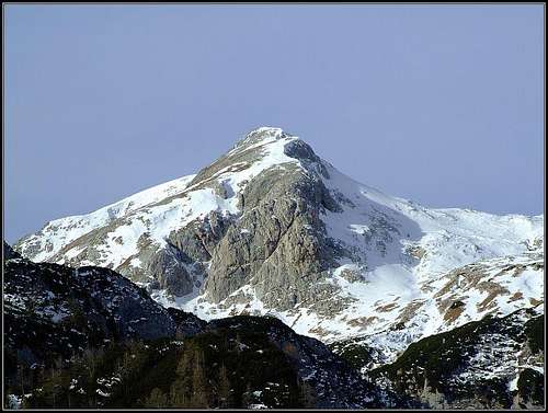 Debeli vrh from the east
 Velebit - Debeli vrh seen from the distance (from Triglav)
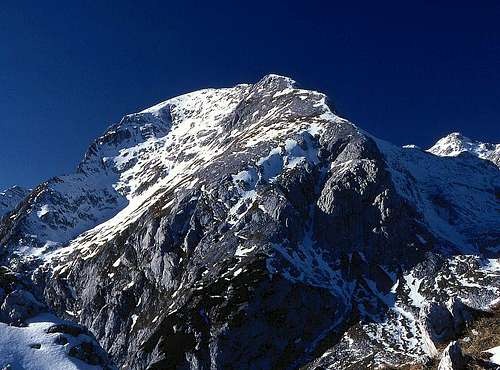
 From the west
What's New On This Page?
> MAJ 1st, 2023: Online map, minor corrections.
> DEC 29th, 2013: SP V3 design updated, some text added.
> SEP 5th, 2004: Initial setup of the page.
Debeli Vrh Gets Presented
Debeli vrh (=Fat Peak) is the king of Bohinj high alpine pastures. Standing north of them, its high, massive posture dominates the high plateau, on the other side there is only a bare, high karst landscape. Being the central figure of Bohinj high mountains, Debeli vrh is also almost the highest there. Only on the very northern edge of the group Vršaki are a few meters higher. The massive character means also a hiking mountain. But the approach to its summit is not just an easy hike. Even the easiest approach from eastern side needs to traverse a sharp notch, where on a few meters easy climbing is needed. And also the rest of the ascent needs some carefulness. In optimal conditions from its fore-summit also skiing is possible.
Position and Geography
South of Triglav and Kanjavec, the mountain ridges of high Bohinj summits resemble a big whirlpool. Its centre is behind (north of) Debeli vrh, where a labyrinth of high carst valleys is in summer almost unpassable. Also almost all marked paths avoid this area. Fog there could mean very small chances to get out of troubles. From this area Debeli vrh rises with a short north ridge. Towards the north-east, Debeli vrh has a short, but steep wall, which is cut by a steep gorge, falling from the notch between the main summit, 2390 m, and the fore-summit, 2365 m. Below this wall a round carst basin lies. Towards the east from the fore-summit, steep rocky and scree slopes are falling down towards the Lazovški preval, 1966 m, a high pass between Debeli vrh and the neighbouring summit of Ogradi, 2087 m. Over this high pass the marked path from Laz pasture towards Velo polje pasture goes. Towards the south-east, Debeli vrh looks like a big shell. Those slopes are rocky and grassy, steep, but through the ravine and upper slopes of the shell they say the ascent is also possible, requiring only steep scramble and some easy climbing. Finally, towards the west the summit has an almost vertical drop, a remote wall, which would require climbing in doubtful rock. South of Debeli vrh there is a beautiful, broad, high alpine pasture, called Laz. Many huts there are now converted to weekend huts, but the general style is preserved.
Getting There
| See full screen |
 Laz alpine pasture Laz alpine pastureFor the broader overview, see the Julian Alps page! In Bohinj valley we arrive by car, bus or train from Bled (by train also from Gorizia). From the main Bohinj valley (Stara Fužina village) we can drive by car towards the north into the Voje valley. After 2 km there's a crossroads, where we take the left forest road. It takes us through the Suha valley to Planina Blato (alpine pasture), 1147 m. There's a big parking place. In summer, the road through Suha valley needs to be paid. Maps: The online map-guidebook on the left is accurate and reliable. Explore it! Clicking on its features you get additional information, but descriptions are in Slovenian language. Yet, you have all that on this page. Julijske Alpe - Vzhodni del (Eastern part). Planinska zveza Slovenije. 1:50.000.
|
Routes Overview
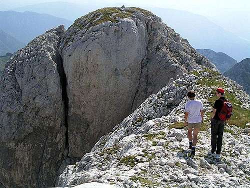
1. From the east. Either from Planina v Lazu (Laz alpine pasture) or Velo polje (valley, alpine pasture) by the marked trail to Lazovški preval (pass), 1966 m. From there by one of two variants towards the west to the fore-summit (weak path, scramble, no marks, T4) and over the notch (easy climb, UIAA I) to the main summit. From Laz 1 h 30 min, from Velo polje 2 h 45 min.
2. By the north ridge. If coming from the north, from Hribarice pass, we must first reach the notch below the N ridge, then by the ridge to the main summit. Easy climb, UIAA I.
For tour skiing, see also the description of this tour: Skiing behind Debeli vrh. It describes the wonderful ski tour from Kanjavec, touching also the northern edge below the Debeli vrh.
Red Tape
The mountain is in the Triglav National Parc. In summer, for the road from Voje valley trough Suha valley up to Blato alpine pasture you should pay toll.
When To Climb
 Debeli vrh from the path Laz - Dedno polje
In summer and autumn - the best months are July to October. In best conditions you can ski down (steep) from the fore-summit. The best months are March to May. Below Debeli vrh (on the eastern and western side) great ski tours lead from Bohinj to Kanjavec summit. Here is the link to The Route behind Debeli vrh.
Camping
The nearest huts are:
- Koča na Planini pri Jezeru, 1453 m, (041)901 999, (050) 632738 and
- Vodnikov dom na Velem polju, 1817 m, (050) 615621.
Official camping place is in Bohinj valley - here is the link to the tourist web site.
Mountain Conditions
For weather see here. Even better site is wunderground - here's the direct link to Kredarica station, 2515 m (below Triglav summit).