
-
 11541 Hits
-
 78.21% Score
-
 10 Votes
|
|
Mountain/Rock |
|---|---|
|
|
46.22608°N / 13.86204°E |
|
|
6450 ft / 1966 m |
|
|
Overview
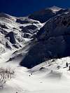
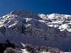
Rodica belongs to the lower Bohinj group mountains.From north, Bohinj looks like a piramide shaped peak. From south the summit is not seen, you are able to see the piramide after you ascent to the Peči. This range (lower Bohinj mountains) starts with Vogel, 1922m, continues towards east overRodica, 1966m, Raskovec, 1967m and reaches the Črna prst 1844m.
The view from the summit is absolutely breath taking. From the north you get a warm greeting from Triglav region. On the sunny days you are able to see the Jadran sea on south.
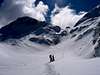
Rodica is not a mountain for hard climbs. It is the paradise for skiers in the winter and for mountaineers who enjoy in easy climbing.
 |  |  |  |  |
Getting There
Rodica can be climbed from south and north.North approach starts from the ski slopes Vogel or from Ribčev Laz (Bohinj)
From south the trailhead starts form the village Rut or Grant. This ascent is more appropriate for winter season.
Maps:
Bohinjsko jezero z okolico, 1 : 25000,
Julijske Alpe - Vzhodni del (Eastern part). Planinska zveza Slovenije. 1:50000.
Mentioning two routes:
Both routes are very good marked :
1. South approach. From Baška grapa- village Rut. You can get there from Koritnica (7 km). From the point where the road ends, you follow signposts. The path lead us through Rutarski and Grantarski forrest to the Mladinska hut. Marked path turns just bellow the hut on right. Threhe path is very exposed, so the is a possibility of avalanches in the winter. After approximately one hour or maybe less you reach the ridge Peči (1727m). From there the ascent becomes steeper. From that point you are able to see Rodica just before us.
The length of the tour:
-Rut-Mladinska hut 1.30 h
-Mladinska hut-Rodica 2 h
Together with the descent 6-7 hours
2. North approach :From Ribčev Laz in Bohinj. The marked route leada us between hotel Jezero and Bellevue into the forrest. Just after you cross the stream, the path becomes steeper. Higher in the forrest you have to be very attentive – signposts. The first flat surface that you reach is alpine meadow Suhe (1400m). From there you enter into highland. Steep path zig zags between dwarf pines and larchs to the Zadnja Suha. From there the path leads us over the ridge to the summit.
The length of the tour:
-Ribčev laz-Suha 2 -2.30 h
-Suha-summit 1.30 h
-Descent 3 h
Together 7-8 hours
 |  |  |  |  |
When To Climb
It is not very difficult ascent, but a long one. You can also ascent in the winter, but beware of avalanches. The main problem is also the fog – orientation. |  |  |  | 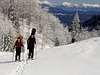 |