
|
|
Mountain/Rock |
|---|---|
|
|
40.03620°N / 107.151°W |
|
|
Rio Blanco |
|
|
Hiking, Mountaineering, Scrambling, Skiing |
|
|
Summer, Fall |
|
|
11820 ft / 3603 m |
|
|
Overview
Devils Causeway is almost certainly the most famous and well known landmark in the Flat Tops Wilderness in Colorado. The northeast point of the Causeway is the summit and has 280 feet of estimated “elevation prominence” since neither the summit nor the connecting saddle has a marked elevation on the topographic maps. For this reason the peak may have 300 feet of prominence and receives a “soft ranking” on peak list.The Causeway itself is a beautiful and spectacularly narrow ridge extending from the summit of the peak and to the southwest. At one place on the Causeway, the Causeway is only four feet wide with cliffs plunging several hundred feet on either side. The acrophobic will shutter at the Causeway, but crossing it is safe enough, in fact I hiked it with my six year old son.
This is a very popular hike in the summer and wildflowers abound. From the summit, there are many lakes and peaks visible. This is also a backpackers’ paradise and the peaks can be reached from several directions and by way of many loop hikes.
The Flat Tops are made of volcanic rock from an ancient eruption several million years ago. The Flat Tops are more of a huge elevated plateau rather than a typical mountain range, but the plateau has been eroded into many individual peaks and summits, and most of them are flat-topped, or dome-like as are the Lost Lakes Peaks. The mountain area composing the Flat Tops contains hundreds of lakes full of fish, and also has some of the most extensive areas above timberline in Colorado.
Flat Tops: 11,000+ Foot Peaks with 300+ feet of Prominence
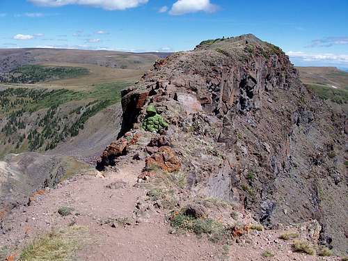
 Looking over the famous Devils Causeway.
Getting There
Stillwater Reservoir TrailheadThe trailhead is at the Stillwater Reservoir. From Yampa, look for the sign on the west side of Highway 131 that points the way to "National Forest Access". Turn west on to County Road 7. Follow County Road 7 for seven miles, to where the road becomes FR 900. Stay on the main road for nine miles and drive to the parking area at Stillwater Reservoir. The road is good for all vehicles in day conditions. A 4wd may be needed early or late season.
 This is the trailhead at Stillwater Reservoir.
Ripple Creek Pass Trailhead
The trailhead is at a large meadow just south of Ripple Creek Pass. The road over Ripple Creek Pass is usually plowed around Memorial Day and stays open until around Thanksgiving, but each year is different.
There are several ways to reach Ripple Creek Pass. There is a road from the south and Trappers Lake, one from the east and Yampa or Phippsburg, one from the northeast and Oak Creek, one from the north and Hayden, and one from the northeast and Pagoda (village) and Hamilton. I know only the road from Hamilton and Pagoda, but very few Coloradoans will be coming from that direction (Craig), so it seems rather pointless to describe the drive. Most people will be driving in from the Trappers Lake or Yampa areas.
Bring the White River Forest Service Map, and park at the meadow just south of Ripple Creek Pass. All roads are in good condition, and can be driven in a car, but 4wd may be needed in bad weather, or early or late season.
Routes Overview
There are many routes to the Devils Causeway, including an almost endless possibility of loop hikes. All routes are very scenic, and all of the routes have their own attractions. With any route you choose, be prepared for some fantastic scenery.Surely, the most popular route up the Causeway and Peak is from Stillwater Reservoir, either from the trail passing Little Causeway Lake and approaching the peak from the northeast or from the trail farther south that passes Mosquito Lake and approaches the Causeway from the southwest. Combining the two routes makes a fantastic 10.5 mile loop.
See the route page for details:
Devils Causeway Loop Via Stillwater Reservoir
Those who don’t want to do the entire 10.5 mile loop can do a 6.0 mile out and back trip using the trail from Stillwater Reservoir and past Little Causeway Lake. This would also be the route to take for the acrophobic who may just want to view the Devils Causeway up close rather than try and cross it.
You also can do a 20+ mile loop (or much longer depending on variations) hike combining the Devils Causeway, the Lost Lakes with the Lost Lakes Peaks from Stillwater Reservoir or from Ripple Creek Pass.
Other possible routes are as follows:
From the northwest, the well-used transfer or East Fork Williams Fork Trail could be used to reach the Lost Lakes Pass and thus joining the route from Ripple Creek Pass. From the Trappers Lake road to the south of the peaks, there are trails up Picket Pen Park or Skinny Fish Basin that meet up with the route from Ripple Creek Pass. There are also several options for loop hikes via any of the trailheads, and it’s not hard to combine several trails into one hike, if you know how to read a topo map.
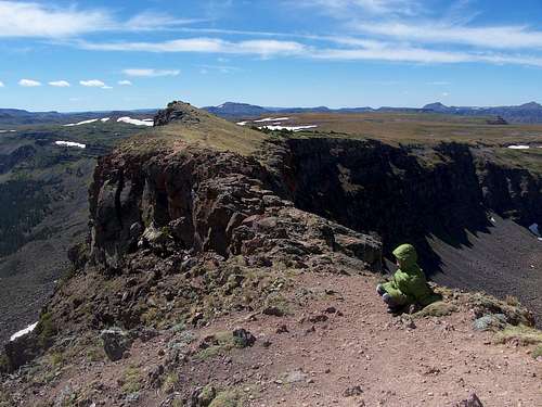
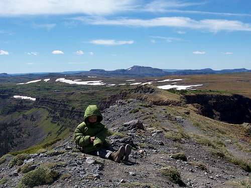
 Kessler rest on the Devils Causeway.
Red Tape
No permits are required. Normal wilderness restrictions apply.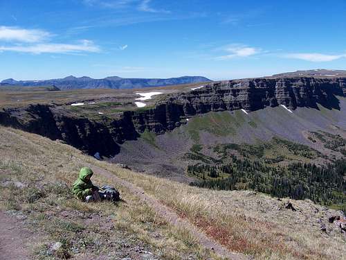 Standard wilderness regulations apply. This Kessler eating lunch on the Devils Causeway Loop.
Camping
If driving in from the east or north, CLICK HERE for current campground information for official Routt National Forest campgrounds. The ones in the Yampa River district are in the same general area as the Devils Causeway.If driving in from the west, CLICK HERE for current campground information for official White River National Forest campgrounds. The ones in the Blanco Ranger District are the campgrounds in the same general area as Devils Causeway.
There are many informal campsites around Ripple Creek Pass and a few around Stillwater Reservoir (though since this is a popular area, informal camping outside the campground may eventually be done away with). There is also a campground to the northeast of the pass at Vaughn Lake, and many along the road to Trappers Lake to the south.
Plenty of campsites exist in the meadows below and surrounding the Devils Causeway below timberline.
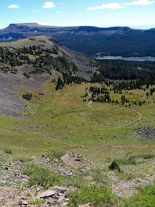 Looking down from the pass near Devils Causeway. Good campsites abound in the meadows below.
When to Climb
Devils Causeway could be climbed year-round by an experienced climbing party, but the roads to Stillwater Reservoir or Ripple Creek Pass is open only from around Memorial Day or early June to sometime in November, so outside this time period, this would probably be a three or four day trip.The Flat Tops (especially the northern section) receive much snow, so despite the lower altitude than the 14'ers, the peaks remain buried in snow until mid-July. Snowshoes are recommended even in June in most years. The Flat Tops have many mosquitoes in July, and sometimes into early August. From September and into December is hunting season, so wear blaze orange and use extreme caution. On the plus side, hunter traffic usually keeps the Ripple Creek Pass road open until around Thanksgiving weekend. Late November might be the best time to make a “winter conditions” ascent because after the road closed, this would be about a three day trip.
If you do climb the Devils Causway in winter, the standard summer route above Little Causeway Lake is one big avalanche slope. The longer more round about route past Mosquito Lake and approaching Devils Causeway from the southwest will be a safer bet in all but the most stable conditions.
 The summit of the Devils Causeway in early September.
Mountain Conditions
CLICK HERE FOR WEATHER FORECAST OF THE AREAWeather and climate data for Marvine Ranch at 7800 feet elevation is below. *National Weather Service Data 1972-1998. Expect much wetter conditions at higher elevations. The area around Devils Causeway will average around 10-15 degrees colder in the daytime than Marvine Ranch; nighttime temperatures won't have as big of a difference.
| MONTH | AVE HIGH | AVE LOW | REC HIGH | REC LOW | AVE PRECIP (in) |
| JAN | 33 | 1 | 59 | -38 | 2.43 |
| FEB | 36 | 3 | 56 | -42 | 2.30 |
| MAR | 42 | 11 | 63 | -32 | 2.55 |
| APR | 49 | 18 | 75 | -16 | 2.20 |
| MAY | 61 | 27 | 78 | 5 | 2.41 |
| JUN | 72 | 33 | 92 | 15 | 1.57 |
| JUL | 77 | 38 | 89 | 23 | 1.94 |
| AUG | 75 | 38 | 90 | 21 | 1.91 |
| SEP | 68 | 31 | 87 | 11 | 2.16 |
| OCT | 57 | 22 | 76 | -10 | 2.16 |
| NOV | 40 | 11 | 65 | -30 | 2.26 |
| DEC | 33 | 2 | 63 | -44 | 2.53 |