
|
|
Mountain/Rock |
|---|---|
|
|
40.08260°N / 107.1355°W |
|
|
Garfield |
|
|
Hiking, Mountaineering, Scrambling, Skiing |
|
|
Summer, Fall |
|
|
12008 ft / 3660 m |
|
|
Overview
"Ptarmigan Flat Top”, a.k.a Peak 12,008, is the quintessential mountain in the Flat Tops. It is steep on most sides, but almost flat on top with vast nearly flat or rolling areas of tundra. It is the 5th highest ranked peak in the Flat Tops and also the highest ranked peak in the Flat Tops without a name.Because the summit was covered in ptarmigans on our ascent on August 18 2012, I propose the name “Ptarmigan Flat Top” for this peak. The approach to the peak is quite scenic and this is one of the easier of the 12,000+ foot peaks in the Flat Tops to climb. The basin to the southeast of the peak holds many popular lakes (the Mandall Lakes), but very few people make the extra effort to climb this peak.
The peak certainly is rich in wildlife. In addition to ptarmigans, we counted 21 marmots and many pikas on our ascent.
The Flat Tops are more of a huge elevated plateau rather than a typical mountain range, but the plateau has been eroded into many individual peaks and summits, and most of them are flat-topped, or dome-like as are the Lost Lakes Peaks. The mountain area composing the Flat Tops contains over 110 lakes full of fish, and also has some of the most extensive areas above timberline in Colorado.
Flat Tops: 11,000+ Foot Peaks with 300+ feet of Prominence
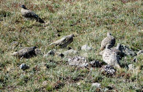 Ptarmigans right on the summit.
Getting There
There are two trailheads which allow easy access to “Ptarmigan Flat Top”. Both are reached via FR 900.Mandall Lakes Trailhead
From Yampa, look for the sign on the west side of Highway 131 that points the way to "National Forest Access". Turn west on to County Road 7. Follow County Road 7 for seven miles, to where the road becomes FR 900. The parking lot is 12.7 miles from Yampa (the junction at Antler’s Inn) and is just beyond the Bear Lake Campgroud.
 Ptarmigan Flat Top from the east.
Stillwater Reservoir Trailhead
From Yampa, look for the sign on the west side of Highway 131 that points the way to "National Forest Access". Turn west on to County Road 7. Follow County Road 7 for seven miles, to where the road becomes FR 900. Stay on the main road for nine miles and drive to the parking area at Stillwater Reservoir. The road is good for all vehicles in day conditions. A 4wd may be needed early or late season.
The winter road closure for the routes above varies. From mid-November through mid-April, the road is closed where the pavement ends (10 miles from Stillwater). In late April, another 7 miles of the road opens allowing access to Bear Lake. In early June (when the snow finally clears) the last 3 miles of the road opens allowing access to Stillwater Reservoir.
Routes Overview
There are two major route possibilities for the ascent of “Ptarmigan Flat Top”. See the route pages for more details.Via Mandall Creek
This is perhaps the easiest route up “Ptarmigan Flat Top”. A good trail is followed up Mandall Creek to near Black Mandall Lake. From there an indistinct trail is followed to Mandall Pass followed by an mostly easy cross country hike to the summit.
This route is 11 miles round trip with about 2500 feet elevation gain.
See the route page for details.
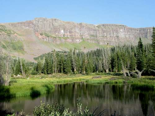
 Ptarmigan Flat Top from Mandall Pass. The route to the summit goes up the grassy slopes to the right before crossing the vast tundra fields to the summit.
Via Stillwater Reservoir
This route is probably almost as easy as the route from Mandall Creek and has less elevation gain. It is mostly above timberline though, so a good weather forecast is essential. Once on the long undulating route to the summit, you will be the highest object around during a thunderstorm.
From the trailhead, the trail to Devils Causeway is followed to the saddle just northeast of the causeway itself. From there, the long ridge and plateau area is followed to the summit of “Ptarmigan Flat Top”.
This route is about 11 miles round trip and other than the first 1.5 miles is above timberline the entire way.
See the route page for details.
Red Tape
No permits are required.Standard Wilderness Regulations apply within the wilderness boundary.
Directly from the National Forest Service:
Basic Rules
• Entering or being in the area with more than 15 people per group, and a maximum combination of 25 people and pack or saddle animals in any one group is prohibited.
• There is no permit system in place in the Flat Tops Wilderness but we do ask that visitors sign in on provided trailhead registration forms.
• Camping within one hundred feet of any lake, stream or trail, or any “No Camping” or “Wilderness Restoration Site” sign or within ¼ mile of Trappers, Hooper, Keener or Smith Lakes is prohibited.
• Building, maintaining, attending or using a campfire within one hundred feet of any lake, stream, or trail or within ¼ miles of Trappers, Hooper, Keener or Smith Lakes is prohibited.
• Storing equipment or personal property or supplies for longer than 10 days is prohibited.
• Hitching, tethering or hobbling any pack or saddle animal within one hundred feet of any lake, stream or trail is prohibited.
• Possessing any pack or saddle animal within ¼ mile of Trappers Lake except for watering or through travel is prohibited.
• Possessing a dog or other animal that is harassing wildlife or people or damaging property is prohibited. There is no leash law in the Flat Tops, however dogs must be kept under verbal control at all times.
• Possessing or using a wagon, cart or other vehicle including a wheelbarrow or game cart is prohibited.
• Shortcutting a switchback in a trail is prohibited.
 The very flat summit of Ptarmigan Flat Top. Make sure to tread lightly in this beautiful area.
Camping
CampgroundsCLICK HERE for current campground information for official Routt National Forest campgrounds. The ones in the Yampa River district are in the same general area as Flat Top Mountain.
The Cold Springs and Horseshoe campgrounds are located near Stillwater Resevoir. The Bear Lake campground is located near Bear Lake. And the East Marvine campground is located near Trappers Lake.
Backcountry Camping
There are many beautiful and ideal campsites between the area just before the trail reaches Mandall Creek (10,200 feet elevation) all the way up to the head of the basin below Mandall Pass. The lakes have excellent campsites, but they are also fairly popular. Bring insect repellent early season.
 Campsite along Mandall Creek.
When to Climb
"Ptarmigan Flat Top" could be climbed year-round by an experienced climbing party, but the roads to Stillwater Reservoir is open only from around Memorial Day or early June to sometime in November, so outside this time period, this would probably be a three day trip.The Flat Tops (especially the northern and western section) receive much snow, so despite the lower altitude than the 14'ers, the peaks remain buried in snow until mid-July. Snowshoes are recommended in June.
The Flat Tops have many mosquitoes in July, and sometimes into early August.
Mid August to mid September is good because the mosquitoes are gone.
From September and into December is hunting season, so wear blaze orange and use extreme caution. On the plus side, hunter traffic usually keeps the roads open until around Thanksgiving weekend. Late November might be the best time to make a “winter conditions” ascent because after the road closed, this would be very long trip.
 Mandall Pass as seen from the south in late August. Usually there is more snow around, but 2012 is an extreme drought year.
Mountain Conditions
Contact the Yampa Ranger District for up-to-date road, trail, and wildfire conditions:PO Box 7
300 Roselawn St.
Yampa, Colorado 80483
970-638-4516
CLICK HERE FOR WEATHER FORECAST OF THE AREA
Weather and climate data for Marvine Ranch at 7800 feet elevation is below. *National Weather Service Data 1972-1998. Expect much wetter conditions at higher elevations. The area around "Ptarmign Flat Top" will average around 10-15 degrees colder in the daytime than Marvine Ranch; nighttime temperatures won't have as big of a difference.
| MONTH | AVE HIGH | AVE LOW | REC HIGH | REC LOW | AVE PRECIP (in) |
| JAN | 33 | 1 | 59 | -38 | 2.43 |
| FEB | 36 | 3 | 56 | -42 | 2.30 |
| MAR | 42 | 11 | 63 | -32 | 2.55 |
| APR | 49 | 18 | 75 | -16 | 2.20 |
| MAY | 61 | 27 | 78 | 5 | 2.41 |
| JUN | 72 | 33 | 92 | 15 | 1.57 |
| JUL | 77 | 38 | 89 | 23 | 1.94 |
| AUG | 75 | 38 | 90 | 21 | 1.91 |
| SEP | 68 | 31 | 87 | 11 | 2.16 |
| OCT | 57 | 22 | 76 | -10 | 2.16 |
| NOV | 40 | 11 | 65 | -30 | 2.26 |
| DEC | 33 | 2 | 63 | -44 | 2.53 |