
|
|
Mountain/Rock |
|---|---|
|
|
40.12800°N / 107.533°W |
|
|
Hiking, Mountaineering, Scrambling |
|
|
Summer |
|
|
10848 ft / 3306 m |
|
|
Overview
Sleepy Cat Peak is a solitary peak tucked in the very quiet northwestern corner of the Flat Tops in Northwest Colorado. The peak isn’t a high mountain by Colorado standards, but is high on the list of the prominence list for Colorado because it stands alone. The climb of the peak is pretty short, but is worthwhile because the summit has a nice view and seems to be seldom visited. There is no trail to the summit of the peak, and there is one class 3 pitch of 30 feet or so to surmount when climbing the standard route presented here.The summit register was placed by me on August 11, 2006. Hunters and shepards (this is a popular hunting and sheep grazing area) may be the mostly likely people to view the peak up close, though it doesn’t seem climbed by that many people, though it is perhaps more popular than might be expected. Since August 11 2006, two more people in one group signed the register in 2006, eleven people in four groups signed the register in 2007 and one person signed in 2008. We were the first ones to sign in 2009 (September 5).
Since Sleepy Cat Peak stands alone, it is highly visible from long distances (i.e. from the Elkhead or Cedar Mountains), but it is not visible from any populated area since it is surrounded by a sea of lower hills. If the weather is good, the peak will provide fantastic views.
The Flat Tops are made of volcanic rock from an ancient eruption several million years ago. The Flat Tops are more of a huge elevated plateau rather than a typical mountain range, but the plateau has been eroded into many individual peaks and summits, and most of them are flat-topped. Sleepy Cat Peak isn’t flat as are most peaks in the Flat Tops, and instead has a different appearance, though it does rise above a relatively flat plateau.
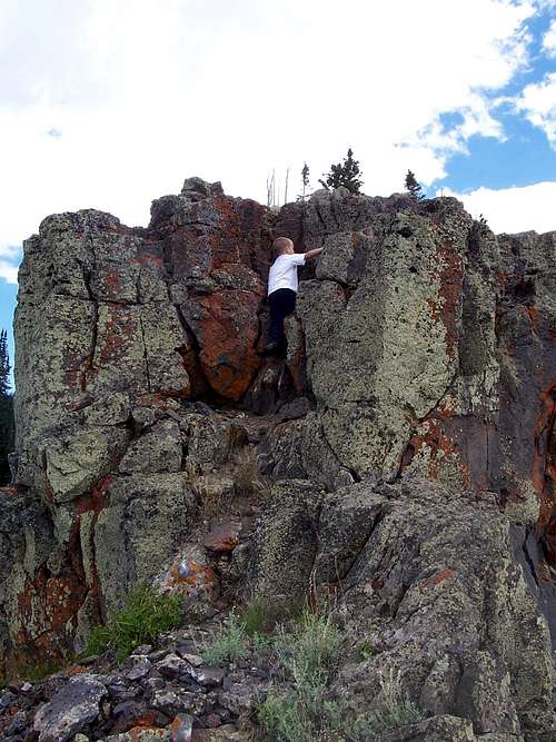
 Part of the class 3 section of the south ridge.
Getting There
Getting there is half the fun, and make sure to have the White River National Forest Map before attempting to drive to the trailhead. This is absolutely necessary and is the only map showing all the roads with the correct numbers. The Colorado Atlas also shows the roads, but they are marked with the incorrect numbers! The topographic maps don’t show the road numbers, not all the roads.The driving directions won’t be too detailed here since you better have the Forest Service Map, and because I came from a different direction (Craig and Hamilton) than most Coloradoans would. Most Coloradoans will approach the peak from Meeker.
The first objective is Yellow Jacket Pass. This is reached from either County Road 15 north of Meeker or south of Hamilton (CR 15 is known as CR 45 for the Moffat County section). From either route (make sure to have the map!!!), drive the good gravel road to Yellow Jacket Pass. Turn east here and onto County Road 48 which becomes FR 250 once it reaches the national forest boundary. Follow FS 250 east for about 10 miles (passing many junctions along the way) to FS 290 which comes in from the left. A high clearance 4wd is required from here on. If you have a car, park here.
If you have a 4wd, turn left on FS 290 and follow it to a junction with FS 299 which comes in on the left. I parked here because FS 290 was a big mud hole beyond here. It was also really rough in one section just beyond, so unless the roads are really dry, park here, even in a 4wd.
 Final cliff band on Sleepy Cat Peak
Routes Overview
We climbed the South Ridge (click on the link), and this seems the most logical route to climb the peak. It is a fun little climb, mostly class 2, but with a short class 3 section, and a class 1 ATV track for part of the way.An alternate route from the basin to the east looks pretty good. The north ridge is certainly doable. The west face from FS 299 would make perhaps the shortest route to the peak, but that side of the mountain has some very thick timber, and would probably be quite bit more difficult than the south ridge.
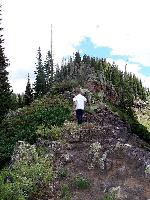 Part of the South Ridge Route.
Red Tape
There is no red tape for climbing this peak. No red tape on this mountain!
Camping
There are no official campgrounds along the access roads. Once you reach the Forest Boundary, there are many great campsites along the road. The trailhead has a nice campsite.The standard South Ridge Route doesn’t have any good campsites along the way, but the basin to the east appears to have some nice and secluded sites. The area around the summit itself has a flat enough site for a tent if the weather is good. You would have to carry all your water up though.
 The meadows east of the peak appear to be good for camping.
When to Climb
Mid July through mid September would the normal hiking and climbing season. Late June or early July might work, but only if the roads will dry. Wet roads are the biggest concern. In dry years, the climbing season would last longer and into sometime in October, but that is dependant on the year.Winter or off-season climbing is certainly possible, but you would have to walk a very long way. The trailhead itself is something like 22 miles round trip from Yellow Jacket Pass, and I’m not sure if the road is even passable to Yellow Jacket Pass in winter. Probably not? Check with the Forest Service and expect a very long trip in the winter season, and one talking several days.
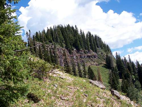 Part of the south ridge in August.
Mountain Conditions
CLICK HERE FOR WEATHER FORECAST OF THE AREAWeather and climate data for Marvine Ranch at 7800 feet elevation is below. *National Weather Service Data 1972-1998. Expect much wetter conditions at higher elevations. The area around Sleepy Cat Peak will average around 10-15 degrees colder in the daytime than Marvine Ranch; nighttime temperatures won't have as big of a difference.
| MONTH | AVE HIGH | AVE LOW | REC HIGH | REC LOW | AVE PRECIP (in) |
| JAN | 33 | 1 | 59 | -38 | 2.43 |
| FEB | 36 | 3 | 56 | -42 | 2.30 |
| MAR | 42 | 11 | 63 | -32 | 2.55 |
| APR | 49 | 18 | 75 | -16 | 2.20 |
| MAY | 61 | 27 | 78 | 5 | 2.41 |
| JUN | 72 | 33 | 92 | 15 | 1.57 |
| JUL | 77 | 38 | 89 | 23 | 1.94 |
| AUG | 75 | 38 | 90 | 21 | 1.91 |
| SEP | 68 | 31 | 87 | 11 | 2.16 |
| OCT | 57 | 22 | 76 | -10 | 2.16 |
| NOV | 40 | 11 | 65 | -30 | 2.26 |
| DEC | 33 | 2 | 63 | -44 | 2.53 |