
|
|
Mountain/Rock |
|---|---|
|
|
38.72350°N / 109.3076°W |
|
|
Grand |
|
|
Trad Climbing |
|
|
Spring, Fall, Winter |
|
|
4900 ft / 1494 m |
|
|
Overview
Dock Rock is one of the easiest rock formations to climb in the Fisher Towers. It is more of a butte than a tower, so it is a bit less impressive than some of the surrounding formations.The rock actually has a variety of routes of various difficulties. The easiest route up is 5.4 to 5.5. There are some pretty serious routes on Dock Rock as well.
Some of the rock on Dock Rock is definitely nasty, dirty, and crumbly, so care must be taken when climbing.
The Fisher Towers are located between Moab and Cisco Utah. The towers are some of the most spectacular and difficult summits to climb in North America. Not only are the summits difficult and spectacular, but these are among the most unusual and unique summits in the world. Also of interest are the smaller towers and canyons of Onion Creek. The whole area is a fantasy land of nature’s handiwork and even photos fail to capture the unusual beauty of the area. I can guarantee you will never see towers like this anywhere in the world!
 Dock Rock (foreground) as seen from near the trailhead.
Getting There
To get to the trailhead, drive north from Moab along Highway 128, or south from Cisco on Highway 128 to the Fisher Towers Road, which branches east from Highway 128 between mile markers 21 and 22. Follow the road to its end at the trailhead. This road is good for all cars.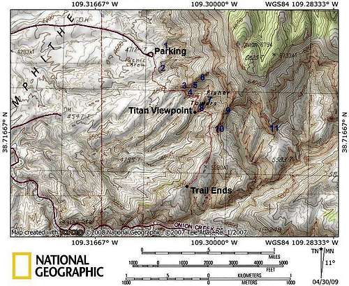 Dock Rock is where the "2" is marked.
Routes
Getting to Dock Rock is easy and it’s right near the parking lot. It is the first formation on the left (east) while following the official hiking trail.Impish 5.4-5.5
This route climbs the northwest corner of Dock Rock. It forms the right edge of the formation when viewed from the parking lot. Once at the top of the first pitch, traverse over to the east side of a formation on a bench and climb to the top. The traverse is easy, but very exposed.
You can rappel off the north face of the formation using a two staged rappel or you can reverse the route.
Chimney Variation 5.6
This is the chimney just around the corner from impish on the far west side of the west face.
You can traverse into the chimney by climbing the rock to the left of the chimney. This is the route we took since Impish was covered in snow and ice. The climb is quite dirty.
 Inside the chimney.
Look See 5.7
This route climbs the most prominent chimney on the west face.
Dock Rock Variation 5.8+
This route climbs the first crack right of Look See.
Smash 5.8 A4
Smash ascends the east side of north face of the formation (far left when viewing the formation from the parking lot).
Red Tape
There is no red tape, but it is important to climb as low impact as possible.When to Climb
Spring or fall are the best times to climb, though they are also the most crowded. Winters are usually sunny, but can be surprisingly cold (nearby Cisco has recorded temps as low as -36F/-38C in winter). Summers are brutal in the afternoons with temps 100F (38C) or much higher; 110F (44C) is possible.Since the Fisher Towers are popular, they might be worth climbing in the off season. As mentioned winters are usually sunny and in summer you could get a very early morning start. If you are climbing in the Spring or Fall, then climbing on a weekday might be a good idea.
 Summit of Dock Rock in early November.
Camping
There is a campground near the trailhead and is available on a first come first serve basis. There is no water.There are also several designated campsites along Onion Creek which is just south of Fisher Towers. Both camping areas have a small fee.
Tower Conditions
Weather and climate data for Cisco/Dewey Bridge is below. *National Weather Service Data 1952-2004.| MONTH | AVE HIGH | AVE LOW | REC HIGH | REC LOW | AVE PRECIP (in) |
| JAN | 38 | 10 | 64 | -36 | .55 |
| FEB | 48 | 19 | 73 | -24 | .41 |
| MAR | 59 | 26 | 84 | 3 | .69 |
| APR | 70 | 35 | 95 | 12 | .67 |
| MAY | 81 | 44 | 105 | 22 | .64 |
| JUN | 92 | 52 | 111 | 33 | .41 |
| JUL | 99 | 60 | 113 | 42 | .50 |
| AUG | 96 | 58 | 110 | 38 | .74 |
| SEP | 87 | 47 | 107 | 23 | .70 |
| OCT | 73 | 35 | 94 | 9 | 1.06 |
| NOV | 55 | 23 | 80 | -5 | .76 |
| DEC | 41 | 14 | 71 | -25 | .53 |
WEATHER FORECAST
For current road, camping, and trail conditions, contact:
Bureau of Land Management
Moab Field Office
82 East Dogwood
Moab, UT 84532
435-259-2100