
|
|
Mountain/Rock |
|---|---|
|
|
38.72510°N / 109.3078°W |
|
|
Grand |
|
|
Trad Climbing |
|
|
Spring, Fall, Winter |
|
|
4720 ft / 1439 m |
|
|
Overview
Lizard Rock is my favorite climb that I've ever done. It is a small and very fun tower located in the Fisher Towers between Moab and Cisco.It is only a few minutes from the parking lot. Lizard Rock is pretty solid rock for the Fisher Towers. It is a popular climb because of easy access.
 Lizard Rock.
Getting There
To get to the trailhead, drive north from Moab along Highway 128, or south from Cisco on Highway 128 to the Fisher Towers Road, which branches east from Highway 128 between mile markers 21 and 22. Follow the road to its end at the trailhead. This road is good for all cars.Lizard Rock is just east of the parking lot.
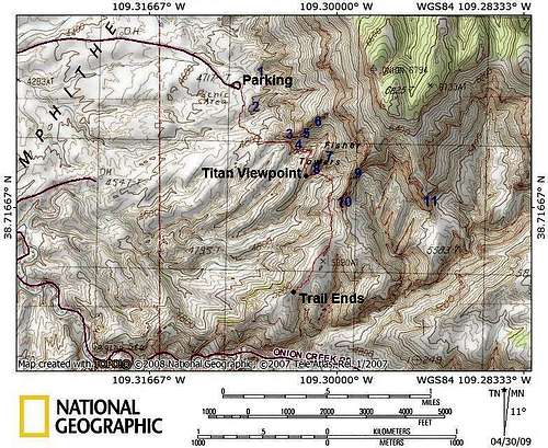 Lizard Rock is near the "P" in PARKING.
Routes
Entry Fee 5.9-This fun route climbs the southwest side of the tower. It first it climbs up a wide crack and then climbs the tower to a flake. The crux of the climb is above the flake. There is a piton near the flake that can be used as an anchor.
At the flake you can traverse right and climb to the top or finish the climb directly. This variation is known as Entry Lizards.
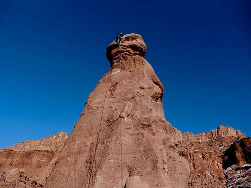 Me topping out on Entry Lizards.
Leaping Lizards 5.10R
This is the direct line up the west face. It follows a thin crack to conglomerate nubs. Continue up the face to the top.
Red Tape
There is no red tape, but it is important to climb as low impact as possible.When to Climb
Spring or fall are the best times to climb, though they are also the most crowded. Winters are usually sunny, but can be surprisingly cold (nearby Cisco has recorded temps as low as -36F/-38C in winter). Summers are brutal in the afternoons with temps 100F (38C) or much higher; 110F (44C) is possible.Since Lizard Rock is so popular, this may be one of the Fisher Towers that might be worth climbing in the off season. As mentioned winters are usually sunny and in summer you could get a very early morning start. If you are climbing in the Spring or Fall, then climbing on a weekday might be a good idea.
Camping
There is a campground near the trailhead and is available on a first come first serve basis. There is no water.There are also several designated campsites along Onion Creek which is just south of Fisher Towers. Both camping areas have a small fee.
Tower Conditions
Weather and climate data for Cisco/Dewey Bridge is below. *National Weather Service Data 1952-2004.| MONTH | AVE HIGH | AVE LOW | REC HIGH | REC LOW | AVE PRECIP (in) |
| JAN | 38 | 10 | 64 | -36 | .55 |
| FEB | 48 | 19 | 73 | -24 | .41 |
| MAR | 59 | 26 | 84 | 3 | .69 |
| APR | 70 | 35 | 95 | 12 | .67 |
| MAY | 81 | 44 | 105 | 22 | .64 |
| JUN | 92 | 52 | 111 | 33 | .41 |
| JUL | 99 | 60 | 113 | 42 | .50 |
| AUG | 96 | 58 | 110 | 38 | .74 |
| SEP | 87 | 47 | 107 | 23 | .70 |
| OCT | 73 | 35 | 94 | 9 | 1.06 |
| NOV | 55 | 23 | 80 | -5 | .76 |
| DEC | 41 | 14 | 71 | -25 | .53 |
WEATHER FORECAST
For current road, camping, and trail conditions, contact:
Bureau of Land Management
Moab Field Office
82 East Dogwood
Moab, UT 84532
435-259-2100