
-
 16161 Hits
-
 88.61% Score
-
 27 Votes
|
|
Mountain/Rock |
|---|---|
|
|
37.94948°N / 122.7796°W |
|
|
490 ft / 149 m |
|
|
Overview
 Double Point and Pelican Lake
Point Reyes National Seashore is one of the most dramatic stretches of coastline in the United States. Separated from the rest of California by the San Andreas Fault, it is a region characterized by primeval forests, lush prairie and a rugged coast that often plunges a hundred feet or more into the surf. In no part of Point Reyes is the drama of the meeting of land and sea more dramatic than at Double Point. Here the seacliffs rise to nearly 500 feet to a bald summit providing 360-degree views of the Point Reyes Peninsula and the Pacific Ocean. Double Point is in many ways the finest destination in the National Seashore. A trip to the area includes trail slung precariously above the sea, an unexpected series of seaside freshwater lakes, dense forests, open prairie, beautiful beaches, a beachside backpackers camp and an incredible waterfall that plunges off the seacliffs directly onto the beach.
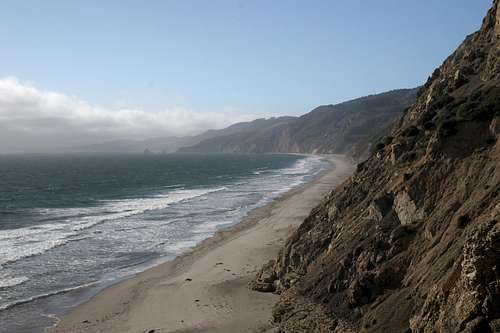
Double Point is located at the southern end of the Point Reyes Peninsula. The northern end of the peninsula is dominated by the Point Reyes itself, which extends nearly 8.5 miles westward into the Pacific as well as Tomales Point, which is the northern extension of the peninsula’s main spine. Tomales Bay is formed when the San Andreas Fault dips below sea level, creating a 15.0 miles spit of water that separates the northern half of Point Reyes from the mainland. The southern half is connected to the mainland of California along the fault line but the southern most point of the peninsula is also separated from the mainland when the San Andreas Fault again drops below sea level, forming the Bolinas Lagoon.
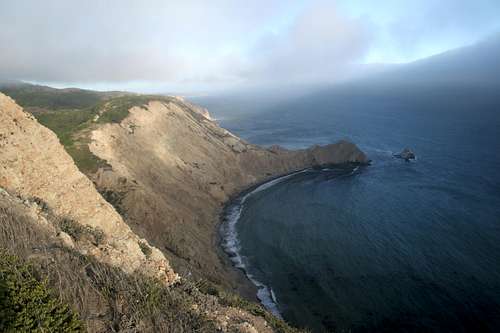
 Double Point from the Alamere Falls spur route
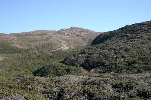
The Point Reyes Peninsula has a high spine running along its axis. In the north the ridge tapers off into the flat prairie penetrated by Drakes Estero. At the southern end of the peninsula this ridge generally slopes downward toward the sea, terminating in cliffs plunging between 100 to 200 feet. The area around Double Point is an exception to this. To the east of double point is a small plateau, which contains a cluster of lakes. It is from this plateau that Double Point rises. Indeed, the largest of the lakes, Pelican Lake, lies adjacent to the peak. Double Point is sometimes referred to as Pelican Hill because of its proximity to the lake.
There is some question as to exactly how Double Point got its name. One possibility is that the name originated from the twin points of land protruding into the sea. The summit is the high point of the northern point. Another possibility is that the name was referring to the northern point, which includes the summit of Double Point and a prominent secondary summit at the end of the point. Either way, the name is appropriate.
 The souther prong of Double Point
Double Point is located along the Coast Trail. This route begins at the Point Reyes Hostel, near Drakes Estero and follows the coastline south for nearly 20 miles. The trail terminates at the Palomarin trailhead. Several trails cut across the width of the Point Reyes Peninsula, providing access to various points of the Coast Trail. The Bear Valley Trail is the most heavily used of these routes. It is possible to reach Double Point by accessing the Coast Trail anywhere to the north and proceeding south to the peak. This route is necessarily an overnight trip due to the length of the routes. Most people approach Double Point from the Palomarin trailhead. This makes an excellent day hike.
Alamere Falls
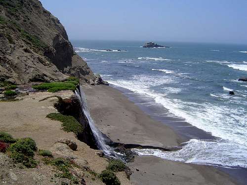 Alamere Falls
Aside from the views from the summit and the cool lakes surrounding it, one of the most outstanding features of Double Point is Alamere Falls. The falls are located at the base of the northern flanks of the peak. Alamere Creek is a perennial stream that drains a large portion of the southern part of the peninsula. The fog and precipitation moving inland from the sea ensure the creek flows year-round, despite its short length. Prior to reaching the shore, the creek enters a narrow gulch and goes over a series of three cataracts. These falls would be an impressive attraction in their own right. However, the creek makes its final leap 50 feet off the cliff to fall directly onto Wildcat Beach. If the tide is in, the falls plunge into the surf.
Getting There
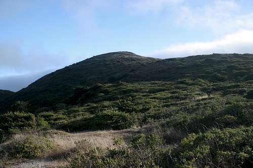 Double Point
From San Francisco, travel north on Highway 101. After crossing the Golden Gate, exit onto Highway 1 and continue west. Pass through the communities of Muir Beach and Stinson Beach. Turn left onto Olema Bolinas Road. Turn right onto Mesa Road and follow it to the trailhead. The road will eventually become a well-maintained gravel road, about a mile before the trailhead.
If coming from the north, one can exit Highway 101 at Petaluma and exit onto East Washington. Travel west across the Petaluma River and turn left onto Petaluma Boulevard. Turn right onto D Street. Remain on D Street which will eventually becomes Point Reyes-Petaluma Road. This road extends several miles to the west. At the stop sign, stay straight onto Platform Bridge Road. Turn right onto Sir Francis Drake Boulevard and left onto Highway 1. Turn right onto Olema Bolinas Road and right onto Mesa Road, which leads to the trailhead.
Red Tape
 Wildcat Beach
Double Point is located in the Philip Burton Wilderness, which in turn is located inside Point Reyes National Seashore. Normal wilderness rules and ethics apply. Wilderness regulations prohibit the use of mechanical forms of travel, including bicycles. This is pertinent for those seeking to approach Double Point from the east. Bicycle approved trails to approach the Double Point area as far as the Wildcat Campground. Bikes will have to be left at the wilderness boundary and the summit must then be approached on foot.
Point Reyes National Seashore
1 Bear Valley Rd.
Point Reyes Station, CA 94956
415-464-5100
Camping
 Alamere Falls
Camping in Point Reyes National Seashore is limited to four backcountry campgrounds. These can only be reached by foot, horseback, or in some cases by bike. The best (and correspondingly the most popular) of these campgrounds is Wildcat Campground. It lies in a beautiful prairie filled valley 1.5 miles north of Double Point. The campground is found immediately adjacent to Wildcat Beach, one of the most attractive stretches of beach in Point Reyes. The beach extends south form the campground to Alamere Falls and the base of Double Point. It is necessary to carry all ones gear to the campground, since it cannot be approached by car. Glen Camp is the next closest campground but it is a few miles inland and not nearly as attractive or convenient as Wildcat.
External Links
[img:280135:alignleft:medium:Alamere Falls]Point Reyes National Seashore
Pointreyes.net
Pointreyes.org