
-
 22299 Hits
-
 92.04% Score
-
 37 Votes
|
|
Area/Range |
|---|---|
|
|
38.05025°N / 122.90131°W |
|
|
Hiking, Scrambling |
|
|
Spring, Summer, Fall, Winter |
|
|
1407 ft / 429 m |
|
|
Overview
Point Reyes contains some of the most dramatic shoreline in the United States. High ridgelines draped in temperate rainforests plunge down to narrow coastal prairies that are perched atop sheer cliffs constantly pounded by the surf. Add to this dramatic landscape, phenomenal beaches, waterfalls plunging into the sea, bizarre rock formations and exquisite oceanside lakes. All of this is contained in a wild landscape created by some of the most violent and powerful forces in nature. The Pacific Ocean and Drake's Bay are separated by Point Reyes
Point Reyes National Seashore is located on the California coast just north of San Francisco. It is often surprising to people how much wild backcountry is located so close to San Francisco and other Bay Area urban centers. Point Reyes is an excellent example. While it is hardly “undiscovered”, the plethora of other attractions, both urban and natural, in addition to its relative isolation, have kept Point Reyes from being totally overrun by hordes of hikers. Indeed, isolation is easily obtained in this seaside wilderness.
The area is a hiker's paradise. Over 170 miles of trail wind through the park, providing far-reaching vistas and intimate encounters with the dense forests, cliffs and beaches. The trails cover a wide range of difficulty, from levelly graded, wide paths to extremely steep routes perched precariously above the ocean. Horseback riding is also allowed and there are several trails outside the wilderness boundary that allow mountain bikes.
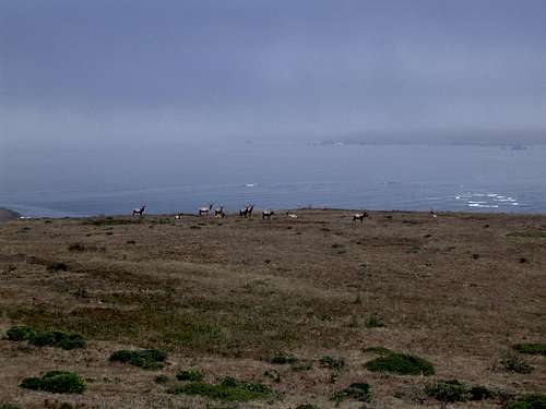
Wildlife observation is one of the most unique opportunities available at Point Reyes. The usual suspects--deer (including some exotics), coyotes, bobcats, raccoons, skunks, etc. are all present. Cougars are also known to roam the area. The varied habitats offer shelter to many species of birds, both permanent residents and migrants; nearly 500 different avian species have been observed. The two stars of the park are elk and whales. There are numerous herds of elk roaming the park, especially in the Tomales Point area. This part of the park is designated as an elk refuge. A herd of elk on a ridgeline with the sea beyond is a most unusual sight. Whales are also visible off of the shore while they migrate north and south. A pleasant California day spent watching gray whales from a grass bluff above a foaming sea is difficult to put out of mind.
National Seashores
 Mt. Wittenberg from Drake's Beach
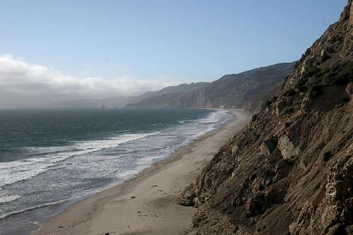
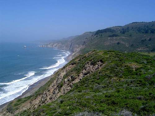
Point Reyes is the easily the most spectacular stretch of shoreline in the National Seashore system. It is the only unit on the west coast (although it should be noted that Olympic National Park does have an excellent coastal unit that could have qualified for National Seashore status). All the other National Seashores administered by the National Park Service are located on the east coast and on the gulf coast. These units are generally part of the barrier island chain (with obvious exceptions like Cape Cod) and are typically little more than large sandbars. Some even contain small wilderness areas, although this is the exception and not the rule. Point Reyes differs entirely from this paradigm. Rather than flat sandy coastal areas, Point Reyes National Seashore is a rugged, densely wooded wild area. Cliffs plunge into a sea populated by numerous seastacks, both large and small.
History
 Tomales Point
Miwok Indians originally occupied the Point Reyes Peninsula. These Native Americans were quite prolific throughout northern California. Numerous village sites still exist within the park boundaries. The first European to arrive at Point Reyes was Sir Francis Drake. It is believed that in 1597 he anchored his ship, the Golden Hinde, in the bay that now bears his name. This was done while he was on his famous piratical circumnavigation around the globe. This is one of the great adventures in human history. Numerous other places and roads in Marin County bear Drake’s name.
Like most of California, Point Reyes eventually came under the control of the Spanish. Some landgrants on the peninsula were issued during this time. From 1812 to 1841 the Russians colonized the area just a few miles north of Point Reyes. Fort Ross was their southernmost outpost. It is unknown whether the Russians came to the peninsula but it certainly a realistic possibility. California eventually came under the control of the United States and the population exploded following the Gold Rush of 1849. In the early 1850’s ranches were established on the peninsula. Many of these ranches exist to this day.
Early in the twentieth century efforts were made to preserve the wild aspects of the Point Reyes Peninsula. Difficulties arose with landowners and ranchers but by the 1960’s a deal had been reached. President Kennedy signed legislation in 1962 that established Point Reyes National Seashore. In 1976 a third of the parks land was protected in the National Wilderness Preservation System.
Geography
 Alamere Falls
California is known for earthquakes and Point Reyes is one of the best places to observe this cataclysmic legacy. The famous San Francisco earthquake of 1906 was a result of movement created by the infamous San Andreas Fault. This fault begins in the Salton Sea and winds its way 800 miles north to Cape Mendocino, in the famed Lost Coast. The fault contributes to many of the most recognizable features in California, including the Transverse Range, the South Coast Range, and the San Francisco Peninsula. The Point Reyes Peninsula is once of the most unique and dramatic results of movement along the San Andreas Fault. The “out-of-placeness” of the peninsula is very apparent and the physical boundaries of the fault are easily observed.
The Olema Valley connects the Point Reyes Peninsula to the mainland of California. The Bolinas Lagoon separates the southern end of the peninsula from the mainland. North of the lagoon is the Olema Valley. The Bolinas Ridge hems in the eastern side of the valley, while the western edge is bordered by Inverness Ridge (most of which is in Point Reyes National Seashore). The Olema Valley eventually disappears beneath Tomales Bay. The bay extends 15 miles to the north, forming a narrow spit of sea sandwiched between the two ridges. Just north of Tomales Bay is Bodega Bay, another geographic legacy of the fault. The Bolinas Lagoon, Olema Valley and Tomales Bay all form the continual and readily identifiable route of the San Andreas Fault and is collectively known as the San Andreas Rift Zone.
The Point Reyes Peninsula itself is roughly triangular shaped. The southern end of the peninsula is tipped by Duxbury Point. The eccentric village of Bolinas occupies the area immediately north. From here, the peninsula extends north, a compact and narrow strip of land. The northern half of the seaward side of the peninsula suddenly extends west into the sea for over ten miles. The westernmost tip of land is the actual Point Reyes. The northern side of this spit of land is the ten mile long Point Reyes Beach. The southern side of the spit of land is Drake’s Beach, which is lined by Drake's Bay. The Point Reyes Peninsula extends north of this area is a narrow, sharply tipped point of land called Tomales Point. This area forms the western border of Tomales Bay.
 Double Point rises from the sea
From Duxbury Point to Tomales Point, the peninsula’s spine consists of the high Inverness Ridge. Mt. Wittenberg is the ridge’s highpoint. Point Reyes Hill, just to north, is only slightly shorter. In many places the ridgeline flattens out close to the coast and a strip of prairie land exists before the land finally plunges into the surf. The land of the actual Point Reyes is almost entirely bereft of trees and prairie dominates. Most of this area has been given over to dairy farming and has been continually used for this purpose since the 1850’s. The original farms still exist within the boundaries of the National Seashore and add a surprisingly pastoral atmosphere.
Water is a dominant feature of the Point Reyes landscape. In addition to the ubiquitous sea, there are several good sized freshwater lakes found at the southern end of the peninsula. When used to finding lakes that are typical legacies of glacial activity, it is often surprising to see the gleaming pools perched precariously on cliffs above the ocean. When some are swollen by rainwater, they sprout waterfalls that plummet into the sea below. In the northern part of the park, Drake's Estero and Limantour Estero extend deep into the landscape, establishing an aquatic presence amidst the coastal prairie.
Philip Burton Wilderness
The Philip Burton Wilderness currently contains 25,952 acres, encompassing roughly one third of the area in Point Reyes National Seashore. The southern third of the peninsula constitutes the bulk of the wilderness, with other, smaller chunks scattered throughout the park. The largest subunit is the Tomales Point. This area serves as an elk refuge and is currently home to two elk herds. The actual Point Reyes and most of Point Reyes Beach are also included in the wilderness. The wilderness is named after a California Congressman who played an important part in wilderness legislation. The wilderness was established in 1976.Peaks
 Point Reyes Hill and Mt. Vision beyond Drake's Beach
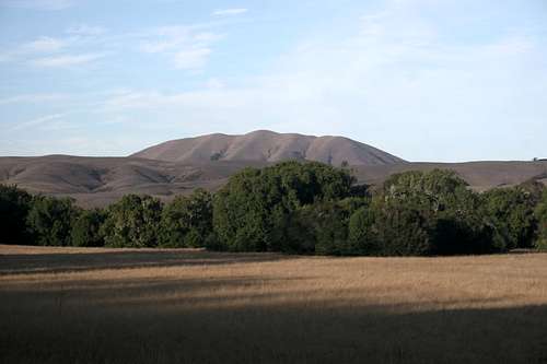
Point Reyes is not an exceedingly high region. Since the peaks are all located directly adjacent to the sea, their height is a little more dramatic than their actual elevation may indicate. The highest points are all located along Inverness Ridge. Mt. Wittenberg (1,407 ft) is the highest point in the park. There are numerous unnamed peaks that exceed 1,000 feet in elevation throughout the area. The named peaks in the national seashore are:
Mt. Wittenberg (1,407 ft)
Point Reyes Hill (1,336 ft)
Firtop (1,324 ft)
Mt. Vision (1,282 ft)
Pablo Point (920 ft)
Double Point (490 ft)
Beaches
 Wildcat Beach
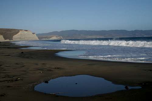
The coast is naturally a constant presence at Point Reyes National Seashore. There are numerous beaches located throughout the park. Point Reyes Beach is the largest, extending over 10 miles of continuous beach. This beach is part of the Philip Burton Wilderness and can only be accessed by car at two points. Just to the south along Drakes Bay is the magnificent Drake's Beach. This is the second largest beach in the park and is lined by dramatic, towering bluffs. San Francisco, the San Francisco Peninsula and most of the Point Reyes Peninsula are visible from this beach.
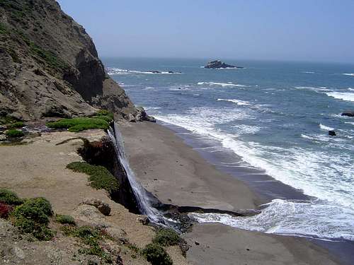
Further south, Wildcat Beach is one of the most popular beaches in the park. "Popularity" does not necessitate crowds, however. It is located far from any roads and is only accessed by a minimum hike of five miles. Moreover, this beach is located next to Wildcat Camp, a backpacker’s campground. If you camp here, the beach is essentially yours. If this were not enough, Alamere Falls is located here. The falls drop over a series of cataracts before finally plunging fifty feet off the cliffs into the surf below. Surprisingly impressive Double Point marks the southern termination of this beach. Palomarin Beach is the southernmost beach within the park boundary. Other beaches, like Sculpture Beach, are exceedingly beautiful but can only be accessed at low tides. In addition to the beaches themselves, there are numerous interesting formations along the Point Reyes Coast. Strange rock formations, caves, arches and natural bridges are found throughout the area.
Lakes
 Pelican Lake
One surprising feature found at the southern end of the Point Reyes Peninsula are the natural lakes. There are five lakes of consequence clustered around the Wildcat Beach area. The northernmost is Wildcat Lake, which is near the Wildcat Camp. Just to the south is Ocean Lake, which is found amidst coastal prairie. Ocean Lake is by far the smallest of the five lakes. Crystal Lake is the highest of the lakes. The two southern lakes are perhaps the best. Both are large lakes. Bass Lake is ringed with trees and is a popular swimming destination. Pelican Lake is the prettiest lake in Point Reyes. Situate in a grassy bowl at the foot of Double Point, it is perched right at the edge of cliffs that drop into the sea.
Neighboring Parks
Three parks lie in the immediate area around Point Reyes National Seashore. Sharing a portion of the Point Reyes Peninsula itself is Tomales Bay State Park. This park contains some trails and provides beach access to Tomales Bay. Samuel P. Taylor State Park lies a little east of the park boundaries and contains several miles of trails that pass through open grassland and redwood groves. Bolinas Ridge, which forms the eastern boundary of the Olema Valley and San Andreas Rift Zone, is the northernmost extension of the Golden Gate National Recreation Area. This park extends south all the way to the Golden Gate and continues throughout the city of San Francisco itself. In addition to these parks, Marin County public lands, Mt. Tamalpais State Park and Muir Woods combine to form a contiguous block of public lands.Getting There
 Black Mountain from across the Olema Valley and San Andreas Rift Zone
The famous California Coast Highway 1 typically follows the contours of the coastline. The best example of this is the Big Sur Coast. In two places does the highway leave the coast and travel inland. The Lost Coast is the most obvious example of this. The other occurrence is Point Reyes. The Coast Highway travels inland from the Bolinas Lagoon and passes through the Olema Valley. From here it travels along the side of Tomales Bay before continuing north to Bodega Bay. This means that the Lost Coast and Point Reyes are the only two areas in California where there is a wilderness coastline. Indeed, along with the Olympic Coast in Washington, these are the only areas in the lower 48 with a wild coastline.
There are numerous ways to access Highway 1 in the Point Reyes area.
Coming from the south
Aside from Highway 1 itself, Panoramic Highway (which traverses Mt. Tamalpais) and Bolinas Road provide access to southern Marin County. Sir Francis Drake Boulevard provides access to the central part of the Marin area. These roads all branch off of Highway 101.
Coming from the east
The Point Reyes-Petaluma Road leads to Petaluma. From here Highway 37 can be accessed. This highway leads to Interstate 80.
Coming from the north
Highway 1 is the primary route coming from the north. However, unless one is already on the coast, it is quicker to travel south on Highway 101 and then head toward the coast on the Point Reyes-Petaluma Road.
Red Tape
 Tule Elk on a bluff above Tomales Bay
Point Reyes has red tape all over the place. The most pertinent issue is the private property and U.S. Coast Guard inholdings within the park boundaries. Be sure to respect owner’s property rights (there are few instances where this is a real issue).
The other significant issue arises with the Philip Burton Wilderness. Normal wilderness rules and ethics apply. Special note: It is illegal to disturb marine mammals resting on the shore. Do not approach them or make loud noises.
Point Reyes National Seashore
1 Bear Valley Rd.
Point Reyes Station, CA 94956
415-464-5100
Camping
 Wildcat Camp lies in the canyon beyond the ridge in the foreground
The only camping allowed within the park boundaries is at the four backpacker’s campgrounds. The four sites are Sky, Glen, Coast and Wildcat. Each site has its own virtues and a fantastic backpacking loop can be done between the sites. The one caveat is that they must be reserved before hand.
The nearest public campground is located at Samuel P. Taylor State Park. This is a full service campground. There are privately owned campgrounds in the surrounding communities. Olema has the closest to most of the park’s trailheads.
Logistical Centers
 Alamere Falls
There are numerous small communities around Point Reyes National Seashore. All of the towns are very attractive and quaint (this is Marin County, after all). The largest is Point Reyes Station. Most services, including a mechanic and grocery store are found here. Other communities in the area are Bolinas, Olema, Inverness Park, Inverness and Marshall. Olema is directly adjacent to the main park visitor center and trailheads, so it caters primarily to Point Reyes travelers. Each community has very fine dining and a small market and deli.
External Links
 Cataracts above Alamere Falls
Point Reyes National Seashore
Pointreyes.net
Pointreyes.org