
-
 30342 Hits
-
 78.1% Score
-
 9 Votes
|
|
Mountain/Rock |
|---|---|
|
|
38.03960°N / 122.8219°W |
|
|
Marin |
|
|
Hiking |
|
|
1407 ft / 429 m |
|
|
Overview

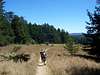
Mount Wittenberg is the highest point within the Point Reyes National Seashore in Marin County. Mount Wittenberg has a prominence value of P1007. The mountain is covered in old growth conifers and bay that are broken up with golden meadows looking out to the Pacific Ocean.
Getting There
Take the 101 Freeway to Marin County, exit onto San Anselmo/Sir Francis Drake. Continue straight on Sir Francis Drake paying close attention to confusing intersections for 20 miles. Reach the junction with the PCH 1 turning right driving .1 mile and turn left onto Bear Valley Road. Drive about .5 miles and turn left at the Red Barn with all the park signage. Drive pass the first buildings to the large public parking area at the end of the road.Route 1 Meadow Trail
From the parking area hike .8 miles along the Bear Valley Trail/Road passing the Wittenberg Trail junction. On your left will be a signed wooden bridge leading up the Meadow Trail. Take this trail for over two miles to another junction with Skyline Trail turn right. Take the trail up to the saddle and junction with the Mount Wittenberg Trail. Turn north onto the Wittenberg Trail and head up to the forested summit.
Roundtrip is around 5 miles with 1300 of gain.
A loop trip can be made with a descent of the Wittenberg Trail.
Route 2 Mount Wittenberg Trail
 |
 |
From the parking area head through the Bear Valley Trailhead and follow the Bear Valley Trail for about a .5 mile. At the signed junction take the Mount Wittenberg Trail up through the trees for 2 miles reaching a open saddle. At the saddle take the right signed trail through the trees to the forested summit. At the summit is two benchmarks from 1930. Leave the summit at return to the saddle for views of the ocean.
Roundtrip is 5 miles with 1300 feet of gain.
A loop trip can be made with a descent of the Meadow Trail.
External Links
Go to Point Reyes National Seashore for entrance fees and camping information.For more information on where to eat and stay in the Point Reyes area go to pointreyes.org.