
-
 13247 Hits
-
 90.8% Score
-
 33 Votes
|
|
Mountain/Rock |
|---|---|
|
|
38.48666°N / 108.04944°W |
|
|
Montrose |
|
|
Trad Climbing, Sport Climbing, Toprope |
|
|
Spring, Summer, Fall, Winter |
|
|
6200 ft / 1890 m |
|
|
Overview
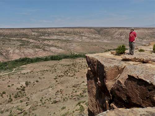
Dry Creek is a local climbing area, located only 14 miles west of my home town Montrose. It is located on Uncompahgre Plateu - large area in western Colorado with rolling hills and many canyons. This is not a tourist destination, only a few local people know about it, and you are unlikely to encounter another climbing group over there.I heard about this place for a while, and failed to find it twice. Luckily, the third time I found the spot (with the help of local friends).
You can drive all the way to the top of the cliffs, so there is only a minimal approach hike depending which climb you want to do. You can top rope (approach length about 10 meters), or you can descend down to the crags and lead.
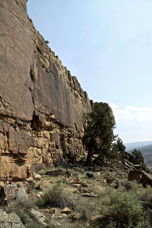
Most routes are bolted, but there are a few trad climbs there as well. The potential for developing new routes is excellent.
The rock is Dakota Sandstone. You can climb here most of the year, summers tend to be hot, but you can find shady spots, and you can bring a cooler with you and have a cold drink waiting for you (Anybody for a cold beer?) Winters should allow climbing on most of the days, unless there is a lot of snow fall.
 Dry Creek Dry Creek |  Arrowleaf Arrowleaf |
 Brown Wall Brown Wall | 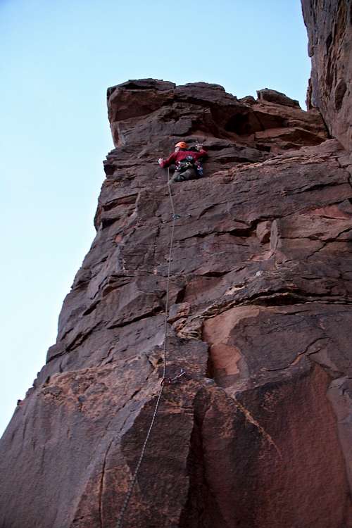 Postman 5.9+ Postman 5.9+ |
Getting There
Did I mention that I tried to find this place twice? It is hard to find, and there is not much information on the web. Mountain Project description was pretty pitiful.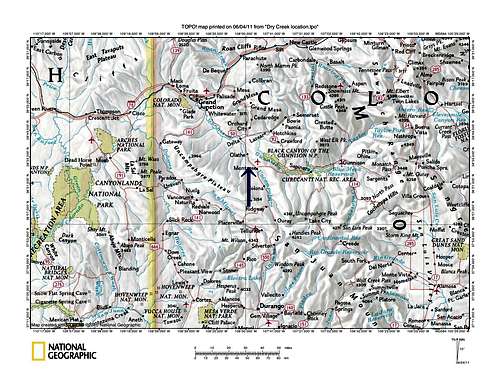 Where is Montrose/Dry Creek? Where is Montrose/Dry Creek? | 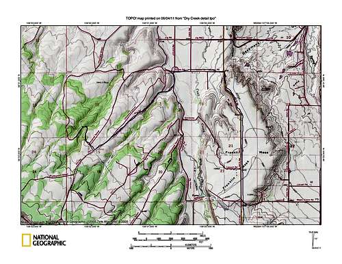 Detailed approach map Detailed approach map |
The directions start from downtown Montrose, the intersection of Main Street and Townsend = US 550.
Option 1: Head west on Main Street, which changes into Spring Creek Rd. after 1.5 miles. Turn right=north on 6000 Rd at 4.9 miles (all distances are from the intersection of Main Street and Townsend).
Turn left=west at 5.9 miles on Maple Groove.
Maple Groove runs into 5875 Rd at 7.2 miles, road turns slightly right=north.
Turn left=west on Kiowa Road at 9.2 miles. Follow the road, which turns sharply left, towards the south.
Turn right=west onto Rim Road 10 10.3 miles.
Option 2 Head west on Main Street, which changes into Spring Creek Rd. But instead of turning onto 60.00 Rd, continue to 5875 Rd. This approach seems easier, but I could not use it since there was some road construction going on.
From Rim Road continue west for 2.3 miles. There will be a dirt road branching off to the right=north. There are no signs pointing you this way. Rim Road is a nice dirt road, you do not need any special vehicle for that part, but after you turn onto "our dirt road = Dry Creek Highway" leading to the crags, the road becomes more bumpy.
There are posts telling you to stay on the road, at some points the road is barely perceptible. It is 1.6 miles from the turn off from Rim Road to the top of the crags, and the last 0.25 miles are very bumpy. You need a 4WD high clearance vehicle for the past 1/4 mile.
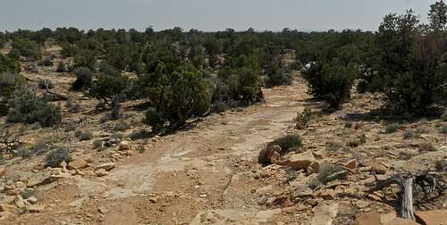 "Dry Creek Highway" "Dry Creek Highway" |
Red Tape

Duchess was hot
There is no red tape. Climbing and parking are free.
You can camp right on the top of the cliff, but there is no water (primitive camping only).
There is a creek running most of the year down in the canyon, but the hike there is very long.
I am not aware of any route descriptions on-line or in print. So, just climb for fun and practice your rating skills :).
I have a copy of sort of a guide done by one of the local climbers, it does name some routes, but a majority of routes have just rating and no name.
(Mountain Project does name some of the routes too.)
Rock climbing
I am happy that I finally found this place. The quality of rock and routes are excellent. Most routes are short, about 30 to 40 feet, some have anchors at the top, and for some you have to build your own anchors. I am sure that this area would get much more attention in a more populated place!I love Dakota Sandstone, and Dry Creek is excellent for solo rope climbing. I like to practice there in the evenings with my Ushba device (commonly used in Ouray Ice Park), and it works great here. You can use other devices for rope soloing - make sure you know how to use it!
Most routes are in 5.10s to 5.11s range, with a few 5.9s, and a couple of 5.6. There are also some corner cracks, which appear very easy, but have no established routes.
Many routes don't have consensus on its grade.
 Descent to the crags Descent to the crags |  Easy corner, 5.7? Easy corner, 5.7? |  Getting ready Getting ready |  5.9 ? 5.9 ? |  Peaceful place to read Peaceful place to read |
 Arete 5.10 ? Arete 5.10 ? |  Duchess in descent gully Duchess in descent gully |  5.7 ? 5.7 ? |  Anchors Anchors |  5.10a ? 5.10a ? |
 5.11ish 5.11ish |  Setting up Top Anchor Setting up Top Anchor |  Dry Creek Sandstone Dry Creek Sandstone |  5.9ish fun route 5.9ish fun route |  Joke anchor Joke anchor |
I received a copy of one of the area developers and he devices the area into Lower, Middle and Upper sections. Each section has a small down climb crack - class 3/4 to get you below the crack (you arrive to its top). There are about 50 total developed routes, and some have names. Consensus on the difficulty varies. And you drive to the top of Lower Section (where I usually climb), and to the Upper section (the turn off is before Lower Section, and is marked with a small cairn on the road).
Soloing with Ushba basic ascender
As I mentioned above, Ushba is designed to catch your fall, and is commonly used in Ouray Ice park. I tested it at Dry Creek, and it worked great on the rock as well. I did not take any fall on it, but tried to sit in it, and it held. I am so happy, I can go for a quick climb, and don't have to look for a partner. Sunset on the cliffs Sunset on the cliffs |  Practicing overhangs Practicing overhangs |  Shadow on the wall Shadow on the wall |  Signing at my son Signing at my son |  Ushba - my rock climbing partner Ushba - my rock climbing partner |
Gear

Setting up a top anchor

Discussing beta with Duchess
Sport climbing gear and some routes do not have anchors, so I usually bring a rack of trad gear, to create an anchor. Most routes do not require more than 4-6 quick draws.
50 meter rope is sufficient since crags are not very high.
Weather
