
-
 21876 Hits
-
 87.31% Score
-
 24 Votes
|
|
Mountain/Rock |
|---|---|
|
|
37.62860°N / 107.636°W |
|
|
La Plata |
|
|
Hiking, Mountaineering, Trad Climbing, Toprope, Ice Climbing, Mixed, Scrambling |
|
|
Summer |
|
|
13700 ft / 4176 m |
|
|
San Juan Range Overview
The San Juan Range is the largest mountain range in Colorado. It dominates southwestern Colorado. In Colorado, the San Juans are second in snowfall only to the Park Range. The San Juan Range is home to 357 peaks above thirteen thousand feet.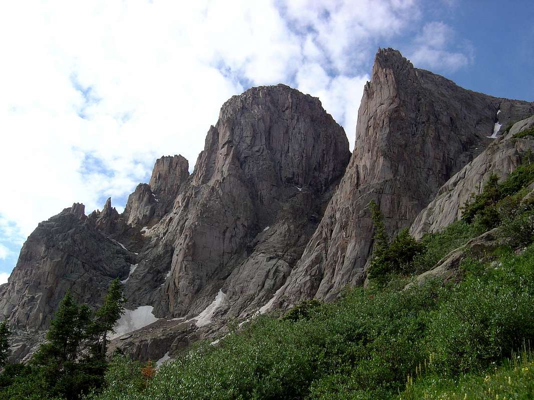
Peak Sixteen, Peak Fifteen & Turret Peak, from left to right
Peak Fifteen Overview
Peak Fifteen lies only 0.2 miles east of centennial thirteener Turret Peak on the south side of Ruby Creek deep in the Weminuche Wilderness. Fifteen is the 93rd highest thirteener in Colorado and 145th highest peak in the state of Colorado. Peak Fifteen was first climbed on August 20, 1940 by H.L. McClintock, Frank McClintock, Joe Merhar and Chris Schoredos (1). Their route is now the standard route described below and is considered a 5.0-5.2 climb (2). Peak Fifteen is one of the elite peaks in Colorado requiring fifth class climbing to reach its summit.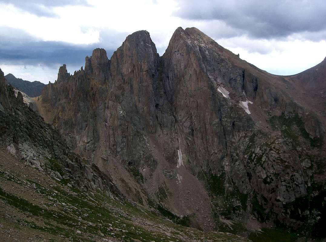
Little Finger, Peak Sixteen, Peak Fifteen & Turret Peak, from left to right
Getting There
Climbing Peak Fifteen by its standard route requires climbing the south-facing couloir splitting Peak Fifteen and Peak Sixteen. There are a number of ways to access the couloir: climbing directly up New York Basin, approaching New York Basin from North Pigeon Creek and approaching New York Basin from Ruby Creek. Ruby Creek appears to be the most common way to access Peak Fifteen. From Ruby Creek, however, there are two ways to access New York Basin. One way is to gain the Pigeon Peak-Turret Peak saddle and the other is to gain the 13290-Little Finger saddle. The variation gaining the 13290-Little Finger saddle is described below because it requires less elevation gain.All of the approaches start from the Needleton Trailhead. The Needleton Trailhead is most commonly reached by the Durango Silverton Narrow Gauge Railroad. Roundtrip tickets cost $65 as of 2007. Avoiding the train requires an additional 1612 feet of elevation gain and 19 miles of hiking from the Purgatory Trailhead (3).
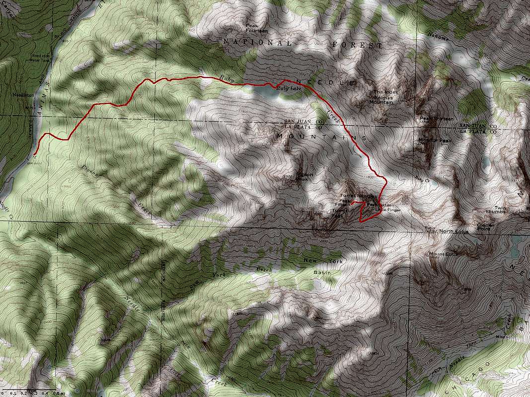
Peak Fifteen’s Standard Route & Ruby Creek Approach. Click to enlarge.
From Needleton, hike 260 yards north on the Animas River Trail, cross Pigeon Creek and hike an additional 0.2 miles to a meadow at 8,260 feet. Hike north looking for a fallen tree. Look for a trail heading east of the tree. This is the Ruby Creek Trail. Follow the Ruby Creek Trail to a small ridge at 9,800 feet. Continue following the Ruby Creek Trail 0.4 miles to another ridge at 10,340 feet. There is a small campsite here. Continue another 0.1 miles east. After descending a steep step in the trail, the Ruby Creek Trail forks for 0.2 miles to avoid cliffs. The upper fork is recommended. After the trails rejoin, continue another 0.7 miles east to a small lake west of Ruby Lake. Cross to Ruby Creek’s north side, follow the Ruby Creek Trail to Ruby Lake and continue hiking along its north side. Immediately after passing Ruby Lake, look for the continuation of the Ruby Creek Trail to the left climbing northeast. Follow the trail to the large meadow east of Ruby Lake at 11,600 feet. This is a great campsite for climbs of Pigeon Peak, Turret Peak, Animas Mountain, Peak Thirteen, Peak Fifteen, Monitor Peak and Peak Sixteen. From 11,600 feet, climb southeast to 13,290-Little Finger saddle. Do a descending traverse west to the base of the south-facing couloir splitting Peak Fifteen and Peak Sixteen. Climb the couloir. There are opportunities to stay west of the couloir to avoid difficulties. The crux is about 20 feet below a rappel station. The rock here will either be snow covered in early summer or wet in late summer. Traverse west along a grassy slope just below the Peak Fifteen-Peak Sixteen saddle. Climb up a near vertical crack to a ledge. Climb northwest to another ledge. Traverse west to a gully. Climb the gully. The terrain above the gully is no more than third class. Most people bring rope and rack, but free soloing is reasonable.
Red Tape
Peak Fifteen is in the Weminuche Willderness; mechanized travel is forbidden.Camping
There are good campsites at 8,260 feet at the junction of the Animas River and Ruby Creek Trails, at 10,340 feet on the Ruby Creek Trail, at the lake west of Ruby Lake and at 11,600 feet in Ruby Creek.External Links
Lists of JohnReferences
1. Trail and Timberline, September 1951.2. San Juan Mountains
3. Colorado's Thirteeners: 13,800 to 13,999 Feet, From Hikes to Climbs