
|
|
Mountain/Rock |
|---|---|
|
|
43.02090°N / 5.49316°W |
|
|
Hiking, Mountaineering |
|
|
Spring, Summer, Fall, Winter |
|
|
6929 ft / 2112 m |
|
|
Overview
Situated between Asturias and León province, the Puerto de Vegarada (Vegarada col) it´s located around interesting 2000 m mountains. This col was one of the scenaries on Spanish Civil War times, because of ist strategical value, and nowadays its possible to find some old entrechments of this bloody period, where Nacionalists, General Franco soldiers, where trying to get Asturias though the mountain passes of the Cordillera Cantábrica massif to take the territories that the Republican army still were above control on Asturias on the North.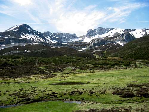
Maybe the most remarkable and the number one keeping the attention of the observers and mountaineers walking on the lonely and mistic Vegarada Col area it´s one called Pico Faro (Lighthouse peak) 2112 m, as a member of the pretty cirque on the West flank of Vegarada col.
I find Pico Faro really attactive for many reasons: great views, over 2000 m peak, snow until the warm days on spring, possibility to reach other interesting and well know summits around (like Huevo peak 2155 m - Egg Peak, or La Morala peak 2103 m).
Also, It can be a good target for beginers or a good challenge for skilled mountaineers on winter conditions or taking the most difficult routes.
 West View West View |  View from Peñas del Mediodía peak View from Peñas del Mediodía peak |  View on a foggy day View on a foggy day |
Getting There
I´ll assume you want to go by car. Public transport will not be a good idea this time, unless you have a great patient and a lot of time...From León: You can choose between LE-311 and then C-626, or N-621 and then LE-321 to go to La Vecilla, I prefer the first one, although both roads has good conditions. Once on La Vecilla, just take LE-321 to the North. You´ll reach Puerto del Vegarada, and then the asphalt will disapear. You can continue 2-3 Km or go on food to be opposite the Faro peak, the road is no bad for cars.
From Asturias: well, unfortunatelly there´s no asphalted road on the North face of the Vegarada col, so you´ll probably need any kind of 4x4 transport to come from Casomera in Asturias.
The other possibilities are:
* Come through Puerto de Pajares N-630, taking then LE-312 on Villamanín. Later take LE-311 to the South, and some Km later take LE-313 to the East towards LE-321.
* Come through Puerto de San Isidro, take LE-323 and go towards Puebla de Lillo, then take LE-331 to the South towars Boñar. On Boñar take C-626 towards La Vecilla. Once on la Vecilla take LE-321 to the North.
 Vegarada Cirque
Red Tape
As in other mountains in León province there´s nothing special to say about. No wild dangerous animals known.PLEASE: Keep the environment clean.
Camping
It´s not allowed to camp in the area and in all León province and Asturias. Only camp sites is the rule, but this is not allways true.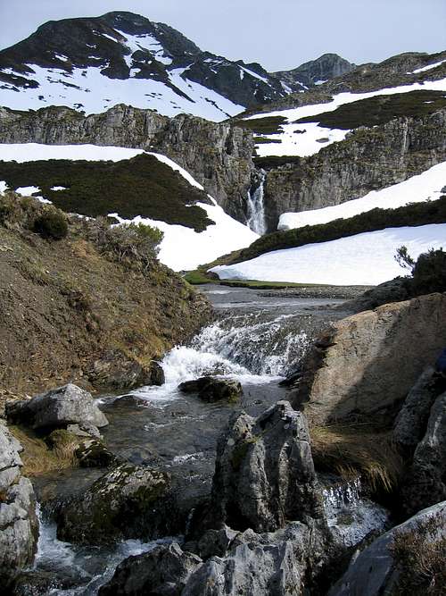 Cascade
When To Climb
In my opinion the best choices are winter and spring, although the other seasons will be OK as well.During winter months you´ll enjoy the snow, a good place to use snow shoes or skies. On spring you can enjoy as well the last snow over the mountains and you´ll see and hear dozens of streams everywhere, you´ll find a lot of little lakes where frogs jump and dive, and some lovely cascade that surely make the route to the summit unforgottenable.
The equipment to reach this summit depends on the route you decide to take and the wheather. A raincoat is a good idea in any case. On snow days take with you gaiters, you can find some Centimetres of snow on your way. A pole can be another good partner, and an ice-axe and crampons a sensible choice on winter conditions.
Camping
Camp is not allowed in León province, except private camp sites.
You have many possibilities of accomodation in the area.
Mountain Conditions
As in the other mountains of Cordillera Cantabrica, you have to have a look the wheather forecast. Remember wheather can change quickly.Fogs are frequent all the year, except summer where sometimes the temperature can reach more than 30º. On winters you´ll ussually find in the col some metres of snow, and of course the temperature will be low.
Also, it´s not extrange to have windy days in this area.
Weather forecast:
[ Left ] Metosat satellite view provided by INM - www.inm.es -
* Note: the map shows the clouds evolution.
[ Right ] Reflectivity map provided by The Weather Channel - www.weather.com -
* Note: the map shows, from blue to red, the power of clouds.
 |  |
For more info use these links: Weather forecast today (English) | Weather forecast today (Spanish)
My Suggestions
* Take a MOBILE PHONE with you. You can use it most of the mountain areas. If you can phone try going up or changing yourposition. I can remember my mobile ringing on the summit of Torre de Friero... I couldn´t believe it! Mobile is the best thing to make an emergency call. Forget about radios.
Take note of this number: 987 718 004. It´s the number of G.R.E.I.M., Guardia Civil Mountain Rescue Team. They are really good proffessionals with lots of years of experience. If you have serious problems phone them: tell them who you are, how many people is in difficulties,try to tell them where you are, or at least a detailed description of the area.
Special info
The meaning in English of some Spanish words.-------------------------------------------------------------------------
* Collado, collada: col, for instance "Collado de Gete"
* Pico: peak, for instance "Pico Fontún"
* Peña: peak (very tipical from León, Asturias, Santander), for instance "Peña Ten"
* Torre: peak (very tipical from León, Asturias, Santander), for instance "Torre del Friero"
* Cueto: peak, for instance "Cueto Millaró"
* Puerto: mountain pass, for instance "Puerto de Pajares"
* Cordillera: big group of mountains, for instance "Cordillera Cantábrica"
* Macizo: group of some mountains or peaks, for instance "Macizo Central, Urrieles of Picos de Europa"
* Cumbre: summit
* Cima: summit
* Canal: corridor, for intance "La Canal de Dobresengos", note it´s in femenine
* Canaleta: narrow corridor
* Hoces: canyon made by a river, for instance "Hoces de Vegacervera", "Hoces de Valdejeja"
* Valle: valley, for intance "Valle de Valdeón"
* Río: river, for instance "Río Torío"
* Horcado: narrow col between two peak, normally difficult to cross, for intance "Horcado de Pambuches"
Books I recomend.
-------------------------------------------------------------------------
Montañas de León (in Spanish only)
Ramón Lozano, Santiago Morán
Everest Editorial
ISBN 84-241-0404-8
Description in detail of more than one hundred routes across the mountain of the León province, including the Picos de Europa Area and many others.
Book details (English) | Book details (Spanish)
50 montañas de la Cordillera Cantábrica (in Spanish only)
David Atela
Desnivel Ediciones
ISBN 84-96192-90-3
Really useful book about the most remarkable mountains in Cordillera Cantábrica massif. It doesn´t containt anything about Picos de Europa area so it lets it go along another interesnting and no so famous mountains.
Book details (Spanish)
Por la Cordillera Cantábrica (Spanish)
Robin Walker
Ediciones Trea
ISBN 84-9704-062-7
Walking in the Cordillera Cantábrica (English)
Robin Walker
Cicerone
ISBN: 1852843632
Another remarkable peaks in the area
 Peñas del Mediodía
* Pico Huevo del Vegarada 2155 m
* La Morala 2103 m
* Peñas del Mediodía 2048 m
* Jeje 2064 m
* Nogales 2076 m
Have a look Nogales and Jeje here
* Bodón 1960 m
The Spanish Corner :-)
Info in Spanish for Spanish Speakers & Spanish Studients:Para todos aquellos que no tengan un inglés súper, y yo me incluyo, he decidido añadir esta sección. También para todos aquellos que estudian o están aprendiendo español.
El Puerto de Vegarada es uno de los lugares más sorprendentes que conozco. Rodeado de montañas de 2000 metros, se trata de un lugar desde el que se puede acceder con relativa facilidad a unas vistas practicamente insuperables de la montaña leonesa.
Es como abrir un catálogo desde el que se divisan cumbres tan notables como los Picos de Europa, el área de Peña Prieta, el Espigüete, los Mampodres, Peña Beza y tantos y tantos picos que apenas alcanza uno a comprender las dimensiones de aquello que alcanza la vista. Merece la pena subir allí y echar un vistazo al catálogo.
External Links
- Cristino Torio´s web site>Cristino Torio´s web site
Web about León Mountain by one of the most well known climber in the León province (Available only in Spanish)
- Web Site about Picos de Europa and the North mountains
Information, photographies a lots of things about Picos de Europa, the tallest montains along Cordillera Cantabrica and the North of Spain. It counts with a valuable informations by the hand of the people on the forum, most of them experts in these mountains. I´m sure they can answer your question even in English, French or German (Available only in Spanish)
- Castilla y León Tourism Official Web Site
You can find here many information about this region, as camp sites, accomodations, monuments, culture, nature, it could be a valuable tool to plan your holidays and trip along the mountains of this region. (Avalaible in many languages)
- Web site about the Riaño mountain
Good information about the area arround this village and the mountains arround (only in Spanish)
- Complete weather information
A lot of information about meteo. Satellite views and different weather forecast models (only in Spanish)