
-
 11408 Hits
-
 89.01% Score
-
 28 Votes
|
|
Mountain/Rock |
|---|---|
|
|
43.10466°N / 4.51341°W |
|
|
Spain |
|
|
Hiking, Mountaineering, Trad Climbing, Ice Climbing, Mixed, Scrambling |
|
|
Spring, Summer, Fall, Winter |
|
|
8668 ft / 2642 m |
|
|
Overview
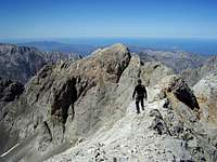
 Llambrión West & Tiro Callejo
The "Torre del Llambrión", also known as 'Llambrión' is the second highest summit of the Picos de Europa range. If 'Torre Cerredo', with its 2.648 meters, is the highest mountain of the range, the 'Llambrión' is 2.642 meters, just 6 meters lower than the 'Cerredo'.
Despite its height, it is neither the most impressive nor the most beautiful mountain of the range, but it contributes to the whole wildlderness and beauty of the central massif of the Picos de Europa.
It was one of the first mountains to be climbed in the Picos. Casiano de Prado (geographer) and Joaquín Boquerín (Engineer of Mines), together with 5 more, were the first men to reach its summit in 1856.
Its name, 'Llambrión', comes from the term 'Llambría', which means 'flat and polished surface of rock'. This rock formation is typical from the limestone mountains, where water and CO2 create a chemical process that slowly disolves the rock creating strange formations and shapes, known as 'Karst'. The whole Picos de Europa is, in fact a limestone outcrop affected by this process and, therefore, full of 'llambrías', caves, and other karstic formations (dolines, poltjes, etc...).
At the base of the north wall of the Torre del LLambrión there is one of the most clear examples of glaciarism in Spain: its very clear the rests of a galcial circus and there is, still, the rest of a glaciar that once existed there: a small patch of ice (of about 2 1/2 meters thick) still remains during the whole summer period.
It is not a walking mountain. The easiest of its routes requires a II grade climb (with a short III grade pass), and all its walls are full with many trad climbing routes.
The authority of its height, the beauty of its routes on high quality limestone rock, and the solitude of the last glacial remains, make the efford to try to conquer its summit. The views from its top include the 'Torre Cerredo', 'Peña Vieja', 'Tesorero', 'Urriellu' and the rest of the gigants of the Central Massif of the Picos de Europa and, of course, the Atlantic Ocean far in the distance...
Routes Overview
 Walking on the ridge
There are, of course, as many ways as one can climb on this mountain, but here is the list with the most common routes on the Torre del Llambrión:
- Normal on the N wall: PD Ascends to the summit starting from the remained ice field at the foot of its north wall, walking over a loose debry gains a narrow chimmeney at this north wall that ends at the very top of the ridge. Some pases of II grade (and a short III grade pass, just before gaining the ridge). Exposed short ridge from the end of the chimmney till the top.
- Rafa-Udaondo: D At the south face, starting from 'Hoyo de los Lagos'. It has 290 m of height gain (maximum V grade).
- South East Ridge: AD Here was done, in 1892, the second ascend to this mountain (due to a mistake finding the 'normal' route. Basically it requires to climb along the ridge that starts at the narrow pass of Tiro Tirso, at the SE of the summit. Requires some III+ passes and it is very exposed.
- Yellow marks route: interesting AD route which starts from the south east end of the 'Hoyo del Llambrión' (west side of the mountain), scrambles over loose rock and then starts a scramble/climb of III grade, with an exposed traverse to gain the ridge, and very exposed from the ridge till the top.
Getting There
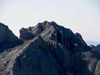 Torre del Llambrión
Fuente Dé offers the easiest access to the mountain, but no the shortest. A cable-lift was build in 1966 to bring visitors from 1.070 m over sea level to a height of 1.834 m in a couple of minutes. From the upper station the mountaineer has to continue walking to the foot of the mountain (read next section). In order to arrive at Fuente Dé (where the cable-lift is), there is a good road (25 km aproximately) that connects it with the big and touristic village of Potes. Potes is easy to reach from Santander, which is connected by highway with Bilbao, where there is an international airport.
Another airport (also with international flights) is at Gijón, in Asturias province. This airport would be the best place to land when you want to reach the region by the west to Cordiñales. Gijón is connected with Oseja de Sajambre, on the way to Posada de Valdeón and to Cordiñanes, at the west base of the mountain.
Anyway, starting from Cordiñales or from Fuente Dé, almost both airports will be even away, and Bilbao Airport has, probably, more connections.
Approach to the Mountain
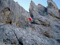 Detail of the crux of Tiro Callejo
Here I will describe the trekking from the upper station of the cable-lift of Fuente Dé till the very foot of the north wall of the Torre del LLambrión, where the climbing routes actually start.
Just outside the upper station, at 1.834 m, a non-paved 4WD track starts heading in NW direction. After a bending to the right a small pass, one km from the station, (Horcadina de Covarrobles) appears. Here the 4WD tracks continue to the right to "Aliva" and to the left to "La Vueltona". When heading to Torre del Llambrión we take the left track (NW) and walk along the impressive SW walls of "Peña Olvidada", another 'gigant' of the Picos de Europa, at our right hand.
1,250 m after the intersection at the "Horcadina de Covarrobles" the 4WD track makes a sharp turn to the left (and down). Here we leave the track to start a long walk on a loose rock path that ascends, still in NW direction, over the inmense rocky debree of "Peña Vieja", above us to the right. Half way (approximately) on this rocky path, and after some zig-zags on it, there is an intersection: to the right (and up) the way heads towards 'Aguja Bustamante' and 'Collado de la Canalona', a pass on the way to "Peña Vieja" route. To the left (actually straight), and levelled, to "Torre de los Horcajos Rojos" and "Cabaña Verónica" (a small metallic mountain hut on the top of a rocky hill). We take the left/straight option, ascending almost till the pass of Horcajos Rojos, but without reaching so far we turn left heading towards 'Cabaña Verónica' hut.
From this point the route gets more difficult to find. There are some cairns here and there, but they get lost in this karstic landscape full of rocks.
Ascend a rock behind the hut and then descend it again by the opposite side. A big 'doline' called "Hoyos Sengros appears, like a big bowl, in front of us. We have to cross it by its right side, trying to find the most comfortable way through the chaos of rocks and not loosing too much height. The best orienteering point is pass called "Collada Blanca" (2.352 m, in some maps), at the opposite side of the bowl.
"Collada Blanca" is the starting point for routes on 'Torre Blanca', at the same ridge of Llambrión. Here "Llambrión" and its summit cairn is clearly visible in front of us. From this saddle (=collada), the path descends a little bit (N) but soon heads with W and SW direction along the north wall of 'Torre Blanca'(up and left). We are crossing the "Hoyo tras el Llambrión", another of those caracteristic bowl-shape depressions (dolines). When following this description, the bottom of that doline has to be to our right.
After traversing the "Hoyo tras el Llambrión" the path ascends steeply towards the end of the valley, what it seems (and it is) an ancient glacial circus, at the foot of Llambrión's walls, the end of our long approach.
2 hours and a half (3 hours when route finding problems) from the upper station of the cable-lift to the walls of Llambrión.
Where to pass the night
Hotels:Picos de Europa is very touristic place and there are plenty of hotels in villages as Potes, Camaleño, Cosgaya, Espinama and in Fuente Dé itself.
Fuente Dé has one of the 'Paradores Nacionales', a kind of luxury hotel, supported by the spanish state.
On this category, I recomend Hotel Nevandi, in Espinama. Normal prices for normal rooms, but excellent food!! and very good buffet breakfast.
In Posada de Valdeón, a village near Cordiñanes, I recomend 'Hotel Cumbres de Valdeón', a certaily luxe (but not very expensive) accomodation.
Huts:
- Cabaña Verónica: very small metallic cabin (9 m2) -part of the american aircraft carrier 'Palau'- at 2.325 m on the top of a rocky hill 2 km to the east from the summit. It has kitchen facilities but only 7 sleeping places. I advise not to use it, but just like an s.o.s. shelter. The boss of the place is called José. Here there is no water (but just bottled).
- Refugio Diego Mella, also known as Refugio de Collado Jermoso, at 2.050 m, in a beautiful location and very close to the walls of Llambrión and, therefore, very adecuate to climb this mountain from its south wall or its north ridge. For the 'normal' route (described in these pages) it is necessary to traverse firstly the N ridge of the mountain to reach the northern slopes, just at the opposite side of the north ridge. Here there is place for 12 persons. Open the whole year. There is water in a close by spring.
- Refugio Julián Delgado Úbeda, also known as Refugio de la Vega de Urriellu, is another open hut (with guard), 4 and a half km to the NE of the mountain. Not the most usual place tom climb this mountain due to the long and difficult approach. Tel. nr.: +34 985925200. Tomás is the guard of the hut.
- Casetón de Liordes, a non guarded small and simple construction at the edge of an idillic alpine grassy field, called 'Vega de Liordes'. It is not close to the south walls of the mountain (2 and a half km to the south of the mountain). There is water in the fields. The accomodation has to be considered a shelter.
Campings:
In Fuente Dé there is "Camping El Redondo"
In Sta. Marina de Valdeón is "Camping El Cares"
Cartography and Literature
Maps:- "PICOS DE EUROPA - Macizos Central y Oriental (Los Urrieles y Andara), Mapa Topográfico Excursionista (at 1:25.000) from Ediciones Adrados
- "Mapa Topográfico Nacional" (at 1:50.000) Sheets nrs.: 55,56,80,81 IGN
-"MAPA EXCURSIONISTA DE LOS PICOS DE EUROPA" (at 1:75.000) from Editorial Adrados
- "Picos de Europa -macizo Central y Oriental- (at 1.40.000) Editorial Alpina
Books:
- "LOS PICOS DE EUROPA -Excursiones, Ascensiones, Escaladas, Travesias- TOMO 1 (GUÍA DEL MACIZO CENTRAL)" Miguel A. Adrados y Jerónimo López, ISBN 84-404-2708-5 (Spanish)
- "Picos de Europa -100 vías de Escalada- Miguel Ángel García Crespo, Ediciones Desnivel, ISBN 84-96192-97-0 (Spanish)
-"PICOS DE EUROPA -Ascensiones y Travesías de dificultad moderada- Miguel Ángel Adrados, ISBN 84-404-4890-2 (Spanish)
Links
Mountain guides in Picos de Europa area:Guías de Montaña Jon Sanz
nikolai79 - Nov 24, 2007 7:38 pm - Voted 10/10
AdditionLlambrión it was supposed to be the highest mountain on Picos de Europa range for many years. People on the villages around had this idea because it was said to be the first summit covered by snow on the first days of winter. When the first geographical expeditions started, it was discovered that Torre Cerredo was really the highest one. ;-) Thanks again for the page Jon
John Climber - Nov 25, 2007 9:25 am - Hasn't voted
Graciasnikolai79, por tus comentarios tan amables. Cierto lo que dices...lo había leído en algún sitio. Quizás por eso fueron un geógrafo y un ingeniero de minas los primeros que subieron allí arriba, para hacer sus mediciones y estudios...y descubrir que Torre Cerredo era más alta.