
-
 11981 Hits
-
 88.61% Score
-
 27 Votes
|
|
Mountain/Rock |
|---|---|
|
|
34.49414°N / 119.79318°W |
|
|
Santa Barbara |
|
|
Sport Climbing |
|
|
Spring, Summer, Fall, Winter |
|
|
1630 ft / 497 m |
|
|
History

You may wonder why these two attractive little formation are called “Fire Crags!” If you are a rock climber you understand the mentality. You are always looking for rock climbs on new crags. You scope out the hillsides for any possible rock formation to get to and explore. Santa Barbara Climbers are no different. Fire Crags, long before they had a name, were noticed and explored by local climbers in the hope for route possibilities. However, the main problem seemed to be the approach. Trumping through rattle snake infested heavy brush posed too much of a risk and hard work to get to a couple of cliffs. Then, there was a forest fire, and a big one at that. Forest fires are a common accurance in our area. This latest fire was called “Painted Cave” fire, named after the road where it originated. Hundreds of luxury homes were burnt and the hillside was left bare and void of brush. From the ashes of this great tragedy rose what we now know as “Fire Crags.” It didn’t take much time for climbers to take advantage of the cleared-out hillside and to give these two rock formations another try.

Fire Crags

Fire Crags are mainly for sport climbing. The rock, like most rock formations in Santa Barbara area, is sandstone and very fragile. A number of critical handholds broke off during the clean up and establishing routes. The first ascentionists were forced to drill out a few pockets where the holds had broken off. This practice led to a great deal of controversy in the area. However, at the end of the day, Fire Crags became a favorite place for climbers seeking steep and bolted climbs, myself included.
Being west facing, Fire Crags stay in the shade during morning hours making them a desireable place to climb during the warm seasons. Fire Crags sport a number of climbs in the 5.11 range. In addition there are several climbs from a 5.6 to mid 5.10 range.
The most popular climb on Fire Crags would have to be “Grib Dat Hole, 11a.” The beginning move is getting past the lip of the overhang, probably the crux. But, the rest of the climb is sustained at mid 10s. This is a powerful climb that will work your forearms, and leave you with a smile on your face. Grib Dat Hole is drawn in green and labled F.
Some of the easiest sections of Fire Crags are used for rock climbing classes. Heavy duty eye bolts are placed on top of the rock to be used for setting up top rope anchors. In any case, all routes lead to double bolt anchors or double cold-shuts near the top of the rock.

Fire Crags consist of two formations. Majority of the routes are on the larger formation ranging from 25 feet on the extreme left, to about 50 feet close to the right side. There are also several short and powerfull climbs on the smaller boulder. The climbs on the short boulder use two to three bolts each.
| Climbs of The Lower Boulder | |
| A | Screaming Knee Knee, 11c |
| B | Flaccidly Flexing Forearms, 11b |
| C | Epic Garuda, 11c |
| D | Cuzco, 12a |
Table of the Routes


| Fire Crags Climbs | |
| A | Europe Revisited, 5.6 |
| B | Tester, 5.8 |
| C | Bent Brain, 5.8 |
| D | Jensen's Jugs, 10b |
| E | Movin' Out, 11c |
| F | Grib Dat Hole, 11a |
| G | Finger Fit, 11b |
| H | Ah, Just Take It... Don't be Shy, 12c |
| I | Face The Seam, 10a |
| J | Black Crack, 5.9 |
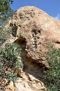
 |  |  |  |  |
The general layout of the routes are shown in the five photos seen above. The routes begin from left to right.
How to Get There
From 101 Freeway take the Highway 154, Cachuma Lake & San Marcos Pass exit. Drive north toward San Marcos Pass to its itersection with Painted Cave road. Turn right on Painted Cave Road and drive about .6 miles to a hairpin turn to the right. Make a U-turn and stop in the tourout on the opposit side facing down the road. Your short hike begins here. Head down a very steep, but short, section to the west. This section has been eroded by rain but soon will lead to a very good trail heading directly westward. You will see the backside of the two unlikely formations.Hike and scramble down the right side, north side, of these two formations. The steep sides of Fire Crags are facing west. To reach the lower boulder follow the small trail going south and passes by the base of all the steeper climbs.