
-
 5605 Hits
-
 88.19% Score
-
 26 Votes
|
|
Mountain/Rock |
|---|---|
|
|
34.47691°N / 119.67946°W |
|
|
Santa Barbara |
|
|
Toprope |
|
|
Spring, Summer, Fall, Winter |
|
|
Overview
 Routes of the south face
 Routes of the west face
 Santa Cruz Island seen from Hole In The Rock
 Gibraltar Rock Area
Perched on the side of a steep rocky ridge is a very large boulder with a prominent feature that is visible from miles away. The feature is a natural hole and it's very unusual to the area. The rock is sandstone but very solid. This is Hole In The Rock.
Hole In The Rock is in the Gibraltar Rock area of the Santa Ynez Mountains of Southern California. This rock formation is across Gibraltar Road from Gibraltar Rock. Gibraltar area is rich in rock formations of all shapes and sizes. The formations in this immediate neighborhood include Upper Gibraltar Rock, Lower Gibraltar Rock, Toxic Waste Wall and The Bolt Ladder. You can find trad routes, sport routes and many top rope possibilities in this area. One of the most accessible formations for a novice is Hole In The Rock. This rock being only thirty feet high and lacking cracks or bolts, all the problems are usually top roped. There are a number of bolt anchors on top for setting up top ropes.
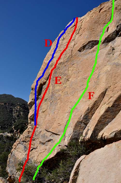
The south face of Hole In The Rock is probably the best place to hold a climbing class for youngsters. The rock is short and the difficulty level is no higher than 5.2 in the middle of the face. If you see your students get cocky on the first try, you can have them try the southwest corner using the holds on the arete, about 5.8. Just in case your students are made of steel and want something even harder, have them try the same southwest arete without using the left corner holds, about 10c.
The west face of Hole In The Rock is really much more challenging than the south face. Climbing directly to the hole and going straight up to the top is about 5.8. This is the most famous route on this rock and it's called Corner Pocket. To make this route much more challenging go left from the hole and then go straight up, Left Of The Hole, 10c. For those looking for a much greater challenge they can try the northwest arete. This is called The Edge, rated 11c. Although this is a rather small formation, there is no other rock in this area offering such a wide variety of climbs.
List of the select routes
Select routes of Hole In The Rock | |
| A | The Edge, 11c, TR |
| B | left Of The Hole, 10c, TR |
| C | Corner Pocket, 5.8, TR |
| D | Well Hung, using the left edge, 5.8, TR |
| E | Well Hung, Not using the left edge, 10b/c, TR |
| F | Center Peace, 5.2, TR |
How to get there
 Hole In The Rock before the fires
From Highway 101 take the Las Positas off ramp. For those coming from the south turn right; for those coming from the north turn left. In either case, drive toward the mountains to the north of Santa Barbara. Continue up Las Positas for .85 miles to State Street, where the name of Las Positas changes to San Roque. Continue driving straight toward the mountains until you come to HWY 192 (Foothill Road) in another .5 mile. Turn right at the intersection and continue up Foothill Road for 1.9 miles to its intersection with Mountain Drive. Turn left onto Mountain Drive and drive for .5 mile to its intersection with Gibraltar Road. Gibralatr Rock is about five miles from this point. You will recognize Gibraltar Rock located to the west of the road when you begin to see a large sandstone formation immediately to your right (east side of the road). This formation is “The Bolt Ladder.” Gibraltar Rock is a little further up the road and to your left. There are ample turnouts for parking between here and the next two turns in the road. Across from Gibraltar Road you will see a an open area and a drainage with a narrow trail on it's south side. Take this trail that will lead to the base of Hole In The Rock.
Camping
 Looking west from the top of Santa Barbara's front range
Unfortunately, there are no campgrounds close and convenient to the Gibraltar area.
There is, however, one very large and well developed campground at Cachuma Lake, and a few less developed ones along Paradise Road off Highway 154. There are also a few campgrounds along Highway 101 at El Capitan State Park and Refugio State Park.
El Capitan Beach Camping
Refugio State Beach Camping
Cachuma Lake