The Idea
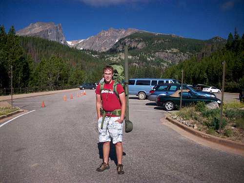
![My fishing trip]() About 45 miles
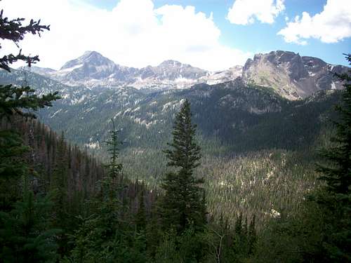
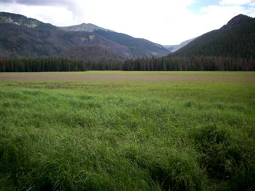
About 45 milesOver the winter when hiking becomes snowshoeing and fly fishing becomes ice fishing, I do my planning for the next year. Usually this consists of writing down some interesting summits and their statistics, maybe planning a camping trip and tackle some 14ers or anything else that looks appealing. I usually concentrate my hiking in RMNP and the immediate area around it, so upon looking through some maps, I realized how many trail systems I’ve never been on that wind through the west side of the park. Living in Loveland, I feel that the drive up to Glacier Gorge is enough, and I get anxious to just hit the trail after an hour of driving. Because of this, the west side and Never Summer range seem to never be in my plans for the next hiking season.
I had long wished to invest in backpacking equipment to tackle some of the more remote areas around the northern front range, and so exploring the west side ultimately gave me an excuse to buy backpacking stuff. I planned two week long trips for the summer, the Fishing trip and the Long trip, first of which would be a trip over Andrews Glacier, down the North Inlet trail to Grand Lake, then back up the Tonahutu Creek trail and over Flattop Mountain. My Long trip would be a traverse over Icefield Pass, around Long Draw Reservoir, down the Grand Ditch road, and down the Tonahutu Creek trail to Grand Lake. From there a climb over Boulder-Grand Pass and down to the Wild Basin TH.
But this report is focused on the Fishing trip.
Day 1 Andrews Creek
![My lovely mother]() My lovely mother
My lovely mother![STOP LOOKING AT IT!!!!]() Tight hipbelt=beer belly
Tight hipbelt=beer belly Our first campsite of the trip would be at the ever popular Andrews Creek site. From the bottom of the Bear Lake parking lot, we took the horse trail down to the main trail to Mills Lake Junction, all while passing tourists gave us the look of 'why do you need so much stuff to go to Mills Lake?' For some reason, people have never seen, or just cannot comprehend the idea of a fly rod case, as I am asked about it every 5 minutes. After the second foot bridge, it became indicative that we leave the questioners behind and take the Fire Trail up. Used by SAR and fire control crews, the Fire Trail is not shown on any map and is considered a secret. Though a bit steeper than the crowded Loch Vale trail, the Fire trail actually cuts off .6 miles to anything past Mills Lake Junction. Upon re-entering the trail at the junction, we then hiked up to the Loch for a break. While my mother went off to the inlet stream to catch some Greenbacks, I decided it was time to visit West Glacier Knob. Passing other outcrops and a shallow pond, I reached the top with time to spare.
![Loch Vale]() From near West Glacier Knob
From near West Glacier Knob
West Glacier Knob is remarkable because you are in an area surrounded by heavily used trails and oft visited peaks, but you will not see another soul while on top. After snapping some quick pictures and building a large summit cairn, I returned back to the busy trails and reconnected with my mother.
As we climbed towards the Andrews Creek site, it became rather apparent that mosquitoes would be a problem. The site sits near a marshy meadow at the bottom of an avalanche path, Andrews Creek runs idly next to the tent pads. After camp was established, I fulfilled my promise to my mother to guide her to Sky Pond. Timberline falls was slippery as usual, but surprisingly less dangerous then when I last remembered it, it helps when your legs grow longer, I suppose. Continuing on from the obligatory stop at Lake of Glass, we spent the rest of the day at pretty Sky Pond.
![Sky Pond]() Sky Pond
Sky Pond![The Cathedral Spires]() The Cathedral Spires
The Cathedral Spires
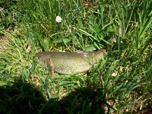
Being my first time fishing at the lake, I was surprised when the first fish I netted was a rather fat Brook Trout. Elsewhere in the National Park, that fish would 9/10 times been the Federally Threatened Greenback Cutthroat trout, not the non-native 'pest' fish that I had landed. Upon catching a few more of them, two things had been determined; these Brook Trout were fat AND stupid. Like stealing candy from a baby. They weren't just fat either, they were morbidly obese.
![Look at the fatty!]() Look at the fatty!
Look at the fatty!
The dimming sky signaled a return to camp, but not before I spotted a small group descending the gully between the Petit Grepon and the Saber. I slept a bit uneasy, though, as the next day surely wouldn't be easy or relaxing.
Day 2 Pine Marten
The second day I awoke to a swarm of mosquitoes hovering around my head. Today’s campsite would be Pine Marten in the Upper North Inlet, crossing the Continental Divide at Andrews Pass. Our route consisted of hiking the trail to Andrews Tarn then up Andrews Glacier to the pass. Camp was dismantled and a cup of oatmeal devoured as we headed up the boulder strewn trail. All along I had thought climbing the glacier would be the hardest part of our trip, but I was wrong. That stupid headwall below Andrews Tarn is the steepest, loosest, crappiest section of any trail I’ve ever seen. Climbing the glacier you expect it to be steep and slippery, but that headwall is just terrible. The best part is when you finally top out and reach the Tarn, THEN you get to see what’s been worrying you for the last two months.
Bottom line, the glacier is much easier to climb with a 50 pound backpack than I assumed. The glacier had kept its snow coating well up to this point, surprisingly, had the slush layer melted down to ice the whole trip would have been a lot harder, at least more exhausting anyways. But as you climb to ‘the hump,’ the sign at Andrews Pass becomes visible and the glacier flattens out. No hidden crevasses collapsed on us, thankfully.
![Climbing to Andrews Pass]() 1/3 of the way up
1/3 of the way up![Looking back down]() Looking back down
Looking back down
As we descended the two long groups of switchbacks above and below NPSJuly, the anguish starts. I’ve thought all along that it’s easier to go up than to come down, especially when you’re being helped along by the extra weight. The Pine Marten site is a nice place to stay, and it’s the closest campsite to Lake Nanita and Nokoni.
![Hallet Creek drainage]() Hallet creek drainage
Hallet creek drainage![Andrews Peak and Ptarmigan Mountain]() Andrews Peak and Ptarmigan Mountain
Andrews Peak and Ptarmigan Mountain
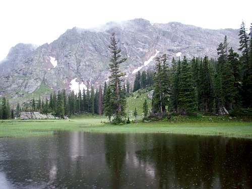
Looking for something to do, we headed off to find Lake Solitude, a shallow pond in a scenic meadow. Late lightening would end our fishing at the lake.
![Lake Solitude]() Lake Solitude
Lake SolitudeDay 3 Big Pool
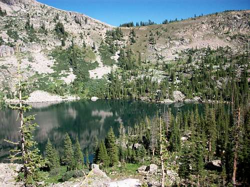
The breaking of camp the third morning was highlighted by a little visitor. While I washed a few dishes in the creek, a fox snuck into camp and rooted around through some garbage. While I noticed him in the forest away from camp, but I didn’t know what he was up to. After he had left and we were packing up, I noticed the lid for our Jetboil had gone missing. That fuzzy bastard took it and some wrappers about 20 feet before dropping it in a clearing. After packing up, we hid our backpacks nearby and headed up the trail to Lake Nokoni, a fairly good sized lake under the shadow of Ptarmigan Mountain. As a hiker I was interested by the routes and hills by the lake, but as a fisherman I knew the lake was barren and would only be a rest stop. Lake Nanita, on the other side of the ridge that separates the lakes, however, is known to hold many large cutthroats.
![Lake Nokoni]() Ptarmigan Mountain
Ptarmigan Mountain![Lake Nokoni]() Lake Nokoni
Lake Nokoni
Lake Nanita was an even larger lake and just a little more scenic, as the rock spires of Ptarmigan Mountain and the steep East face of Andrews Peak stood out boldly above the west shore. While fishing was excellent, I spent more time studying these peaks wishing I had set aside time to climb them.
![Ptarmigan Mountain from Lake Nanita]() Ptarmigan Mountain from Lake Nanita
Ptarmigan Mountain from Lake Nanita![Andrews Peak and unnamed point]() Andrews Peak and unnamed point
Andrews Peak and unnamed point
After a warm summertime nap on the rocks, we had decided it would be best to head down to our campsite at Big Pool. Having hiked back to North Inlet Junction, we set off down the trail past the sign for the Foot Bridge site, where we were originally supposed to stay, but was closed because of the pine bark beetle infestation. Though I fished the deep waters of Big Pool, I didn’t have the desire to jump in even though I could have used a shower.
Day 4 Grand Lake
Sadly, the day we went to Grand Lake was my favorite day. I know it’s kind of sick that I preferred eating pizza in a tourist trap then hiking through a place I’d never been before, but it’s true, that hotel bed was refreshing. Upon tearing down camp at Big Pool, we worked our way down to pretty Cascade Falls, a considerable drop in North Inlet Creek. There, at 8800’, 2600’ below treeline, I saw the most fat, prolific marmot I’d ever seen. Makes you wonder why you don’t see more marmots below treeline, where food and shelter are abundant, why wouldn’t they choose to thrive like the one at Cascade Falls? Anyhow, I was anxious to get some real food in Grand Lake, so we continued on to Summerland Park where a large bull moose had decided to call home.
![Cascade Falls]() Cascade Falls
Cascade Falls![Moose]() Moose in Summerland Park
Moose in Summerland Park
From the North Inlet TH, it was a good mile to our hotel, but I used it accordingly to plan my next three meals in town. After hitching a ride with the nice hotel manager, we stopped at Grand Pizza where all the staff are Romanian. Picking up some ice cream, we leisurely sauntered back to the hotel room and took a quick nap. The Gateway Inn has a great little restaurant in it that makes some good burgers if you’re ever in the area. Unfortunately, rain began to fall heavily sometime around 7:00 while we ate dinner, and I treated myself to watching the Rockies get torn apart by the worst team in the NL as I fell asleep.
Day 5 Sunset
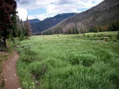
It had begun raining the night before, and it never really would stop until 4 days later, regardless of where we were. A quick breakfast of biscuits and gravy and a pit stop at the Circle D to replenish our bear canister and we were off. Judging by how I remembered the pine bark beetle in the Kawuneeche valley, I had thought that we’d be walking through four miles of dead trees, but I was again pleasantly surprised to find it was actually quite green and lush. I had planned to climb either Green Mountain or Mount Patterson that day, but the sun in Big Meadows was just to warm and inviting for me to leave it. As my mother fished the broad meadow, I basked in the suns welcoming warmth, watching the clouds roll over the mountains I someday wish to climb.
![Big Meadows]() Lower Big Meadows
Lower Big Meadows![Upper Big Meadows]() Upper Big Meadows
Upper Big Meadows
By the time we got moving again, the clouds reinforced their control over the day and let loose once again. Our site at Sunset had been recently relocated to on top a knoll, and with the lack of tree cover, we had to wait a good time for a stoppage in the downpour to put up the tents. At five o’clock I decided enough was enough and just gave up the prospect of exploring the area and just went to bed.
Day 6 Renegade
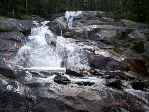
It’s never quite easy to get out of your nice warm sleeping bag to step out into the brisk morning, but it’s even more disenchanting to leave open the tent to a world soaked with water. That’s how the final two days of our trip could be described, soaked. We made great time up to Granite Falls, then to our next site, NPSRenegade at about 10am, early enough that there were still people at the site. There were two of them from St. Louis on vacation for the week.
![Granite Falls]() Granite Falls
Granite Falls![Tonahutu Meadows]() Tonahutu Meadows
Tonahutu Meadows
We dropped our stuff off and hid the bear canister and headed up to Haynach Lakes while the sun was shining, but unfortunately it did not last. Strangely exhausted, we took cover under a stand of trees waiting for the storm to pass. It never did.
![Nakai Peak]() Nakai Peak from Haynach Lakes
Nakai Peak from Haynach Lakes![Haynach lakes]() Haynach Lakes
Haynach Lakes
Walking back to the site, I felt something I’d never felt before, the feeling of being unwelcome in the mountains I call home. Nothing was strange about being rained on in an afternoon in Rocky Mountain National Park, but something was up in that little valley that held Haynach Lakes that made me uneasy. Low hanging clouds hugged the sides of the gorge and blocked view of Nakai Peak, which I had hoped climb. The eeriness was unbearable.
![The fog rolls in]() The fog rolls in
The fog rolls in![Eery]() Eery
Eery
After the people left from the Renegade site, I was placed in a conundrum. There was only room for one small tent by the silver arrow, and the only other place was clearly a drainage basin where puddles had been forming. I got the puddle basin on the rainy day. Nothing makes you feel more comfortable than that! Being our last night, I decided to clear the bear canister of extra food so I wouldn’t be carrying it next morning, if not just to raise my spirits on a cold wet day. I half expected to wake up in a puddle that morning.
Day 7 Flattop Mountain
Alas, I awoke not in a puddle, but in the midst of a glorious morning. My luck had changed, as the pessimist in me foretold a day of lightning and disaster as we hiked hours over featureless tundra, instead the optimist prevailed. As the clouds rolled up the valley below us, I was rewarded with views of the mountains that were socked in yesterday. After a quick break exploring the Eureka Ditch high upon Bighorn Flats, we continued our march ever onwards to Flattop and home.
![Bighorn Flats and Nakai Peak]() Bighorn Flats and Nakai Peak
Bighorn Flats and Nakai Peak![Looking back to Grand Lake]() Looking back to Grand Lake
Looking back to Grand Lake
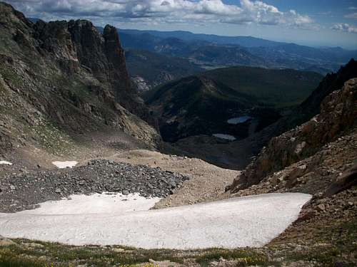
Flattop Mountain was crowded as always, and I was reminded of the frustration the mountains present. As clouds rolled in from the north, I had overheard a pair of hikers who decided not to do the irresponsible thing and climb Hallets Peak in threatening weather, but to head back down the trail and climb it another day. It was only 10 o’clock in the morning.
![Snowdrift Peak]() Snowdrift Peak
Snowdrift Peak![Odessa Gorge]() Odessa Gorge
Odessa Gorge
Sometimes you do everything right, you start early, you make it to the top at a reasonable time, and you still get screwed. Sometimes people head up that trail at 10 o’clock and make it up Hallets by 4 without a cloud in the sky. Instead of being resentful of something you can’t control, like the weather, they headed back down towards treeline without a word. It was a humbling 4 miles back to the car; I’ll say that, I’m truly privileged to have taken a trip that billions of people will never have the opportunity to take.


Comments
Post a Comment