Intro
Every year, we go back to Nebraska to see family. And every year, we visit some nifty place along the way - we've been to the Tetons a couple times, Yellowstone MANY times, and this year we thought of a different place for once - Rocky Mountain National Park. My dad hadn't been there in 49 years, mom's never been there and neither have I. So it should be great!
We stayed in Estes Park, and the two most popular activities of the trip were hiking and stuffing our greasy maws with equally greasy Cheese Whiz, yum.
If I had my way on the trip, we'd be doing scrambles and snow climbs, skiing couloirs, all that jazz. But my parents don't have crampons or ice axes, scrambling makes my mom nervous, and she doesn't like steep skiing either. But it's okay. As long as I'm in the mountains, life's great.
NOTE: I'm a bit of an HTML newbie, so sorry if this is a little wierd looking in spots.
Exhibit A: Chasm Lake attempt, Battle Mountain attempt
8 miles, 2300 feet, highpoint 11,400 feet
"Remember, s*** happens"
Ooh, two attempts, ouch. But both were not achieved for legitimate reasons...it was also this trip that the infamous 'low' took place, and I'll get to that.
We decided to do this hike first because it was semi-mellow and didn't top out to high in case someone got altitude issues. It was awesome, mainly because of two words:
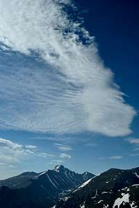
LONGS PEAK.
It's east face, the Diamond, is just staring at you the whole time on this hike. It's straight-up vertical for 2000-odd feet. It pretty much had me mesmerized the whole time.
![The Diamond]() THE DIAMOND!
THE DIAMOND!![Longs and Lady W]() first view
first view
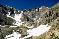
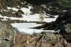
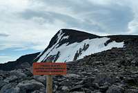
Within the last half mile or so to Chasm Lake, we reached a snowfield that was kinda (very) steep, and we didn't really want to cross it because a fall would be pretty bad for your health.
Now of course my ice axe was in the back of the car, and my crampons are a thousand miles away in my basement. So we opted to turn around, and head for Battle Mountain (12,044 feet) instead.
![Longs]() The snowfield that turned us back
The snowfield that turned us back![Bootshot!]() Bootshot!
Bootshot!![Peacock Pool and Meeker]() Peacock Pool and Meeker
Peacock Pool and Meeker
Now of course, NO trip is complete with some epic place to lighten your load. And I don't mean a good place to catch your breath...
![Sky Potty]() Sky potty! It's got a great view of Meeker and Longs...
Sky potty! It's got a great view of Meeker and Longs...
Definitely ranks up there with my favorite Johns...(somewhere above John Paul Jones and below John Lennon) (insert 'bad joke' comment here...)
Now anyway.
We were back on the Longs Peak trail heading to Granite Pass, and from there to Battle Mountain. It was about halfway to the pass when the 'low' occured. Now when I'm hiking, I keep my camera strap around my neck, and have it resting in my belt case for it, with the case open.
I didn't realize it, but I had my case open
without the strap on my neck. I didn't even think about it. My toe caught a rock, and my nice, new, $600 Nikon SLR decided it would be fun to go BASE jumping.
Hearing the crack when the camera hit the ground was sickening. I dropped my trekking poles and picked it up. My first thought was "The lens!". The lens was fine. Whew. Everything else looked alright. YES! That was close!
Or so I thought.
I went to turn it on. Nothing happened.
"oh no, Oh no!!" I panicked. That's when I noticed the LCD screen was shattered and no longed worked.
"No, No NO!!". I was seriously PO'd.
Thankfully, I discovered the camera could still take pictures, and I could still see my shutter speed and aperture in the viewfinder, but couldn't adjust burst, ISO, metering, use the built in editing, etc.
It could've been worse. Otherwise, this trip was awesome.
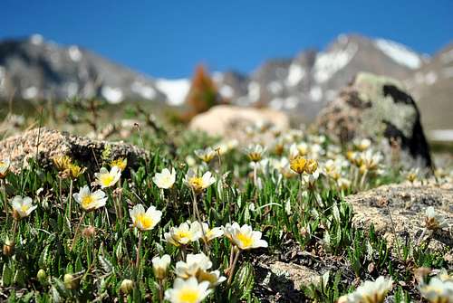
Oh, and my favorite picture of this hike. I almost forgot.
![Flowers]() money shot
money shotTrip Numero Dose: Sundance Mtn and Tombstone Ridge
4 miles, 800 feet
"We have to be taking hikes with all the crap we've been eating!" -Dad
This was just kind of our chill day, and it's interesting that here climbing a 12k mountain is a "chill day", whereas back in WA that's an undertaking.
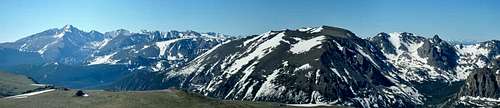
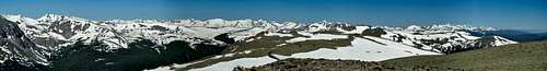
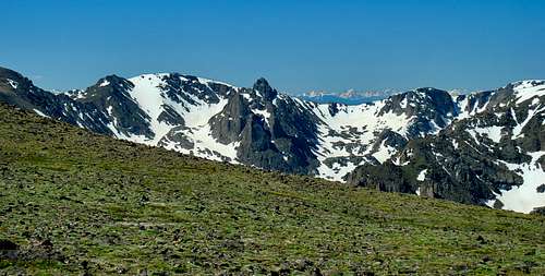
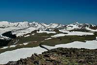
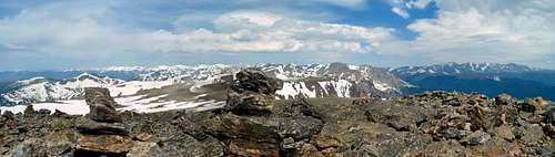
Sundance Mtn is the highpoint of Trail Ridge, and summiting it is an easy cross country hike with some awesome scenery. After relaxing on top for a good 30 mins or so, we hiked along Tombstone Ridge on the Ute Trail for a bit just for fun.
Chilling on the summit for so long, with nothing but mountains to see in all directions, is probably one of the most relaxing, meditative times I've had in the mountains. We could see the Continental Divide to the South, The Gore Range, the Mummy Range, the Rawah Range, the Never Summer Mountains (naturally looking very wintery), the Great Plains, Estes Park, and even the Medicine Bow Mountains in Wyoming. And all topped with perfect blue skies.
It was amazing that in the bustle of one of the most popular areas of a popular national park, we had solitude.
![Pano from Sundance]() Pano from Sundance
Pano from Sundance![Sundance Mountain Pano]() Pano from Sundance
Pano from Sundance![Hayden Spire]() Hayden Spire from Sundance
Hayden Spire from Sundance![Trail Ridge Road]() Trail Ridge Road
Trail Ridge Road![Descending Sundance]() on the way down
on the way down
When we got back to town I went bouldering for the first time since I injured my hands. It was great! Just some gym climbing but that's better than none at all!
To top it off: Hallett Peak and Flattop Mtn
10 miles, 3300 feet
"This trip presented many obstacles...eating a bagel being one of them" -Dad
This truly was topping it off, since I reach the highest point I've ever been before - 12,713 feet on the summit of Hallett Peak.
My personal favorite trip of the trip, it was also the most challenging for sure.
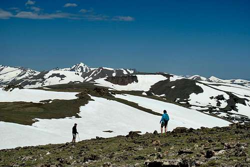
It starts by mingling with the yuppie crowd around Bear Lake, then climbing moderately before hitting snow. LOTS of snow! From about 9800 feet to treeline (11,400 feet) was solid snow, but there was a decent, albeit meandering and slippery, bootpack, and it served was well up to treeline. That's where I saw my first ptarmigan!
This one was granite-flavored, once we got near the summit of Flattop, and saw a couple of ptarmigans that were still snow-flavored! Nice!
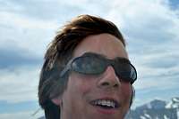
![ITS WINDY]() Me just loving the wind!
Me just loving the wind!
Speaking of the wind, it was WINDY and COLD. It was 50 degrees or so out with continous 40 mph winds. Brr, senor!
There was a gnarly cornice near the top of Flattop. We gave it wide berth. I could've sworn I had a picture of it but aparantely I didn't. Bummer.
After summiting Flattop, we had a good view of the Tyndall Glacier that rests between Hallett and Flattop. In the steepest section of the headwall, about 60 degrees at least, we saw ski tracks! Now I'll ski just about anything I come across but no way would I do that...scary stuff!
From here it was 1/2 mile and 300 feet up to the summit of Hallett. It's class 2. Now anything over class 1 usually slows my mom down a bit, and she decided she didn't want to continue. Dad said he'd stay with her, and I could summit on my own. Well okay then. Why not?
![Liability?]() Liability much?
Liability much?![Parting view]() Hallett with Longs peeking over his shoulder.
Hallett with Longs peeking over his shoulder.![Selfie]() Summit Selfie
Summit Selfie![register]() register
register
Hallett was an awesome summit, with great views all around. Thank goodness for the wind blocks too!
And FYI, the register needs a new pen! It leaks! I still have ink on my hands and it's been over a week! :)
Parting words...
This was an amazing trip. The scenery was spectacular to say the least. I may not have gotten to do as much climbing, as opposed to just hiking, that I wanted, but there will be times for that. And I now for sure I will come back.
A TR with a few more pictures can be found
here.
Comments
No comments posted yet.