I guess if a trip report has to have a theme, then the theme of this one would be
Knowing When to Say When. The idea for this title came from the fact that on our 2007 trip to Rocky Mountain National Park (RMNP), my hiking partner and I decided to turn around five out of seven times on the hikes/climbs we were attempting.
This is not the story of some epic climbing adventure where we decided to turn around before the trip ended in tragedy. No, this is the story of two average hikers, doing some fairly basic hiking and climbing, on routes not overly difficult. But for one or more reasons, five out of seven times we chose to turn around instead of proceeding up the mountain. If it would have been flip flopped, and five out of seven times we made it to our destination, then it wouldn’t have been much of a story. But after several days in a row of this, there was a trend, and we were starting to get frustrated.
After having a year to reflect back on this trip I realize that there were several reasons for our lack of success: poor judgment on the day of the hike; relying too heavily on one guide book; insufficient pre-trip planning; bad weather; and most importantly, a personal evaluation of our climbing skills where we decided that a particular “move” or “climb” exceeded our skill level.
Seven Day Plan
I went on this trip with my very good friend Rob Wood. The build up for this trip started when Rob and I were leaving RMNP on our first trip together, in August 2006.
The 2006 trip was great. Summiting Longs Peak was the highlight, but we also had two other long hikes where Rob took me off the standard trails and we made it up to Boulder-Grand Pass in Wild Basin and out to Green and Italy Lakes in Glacier Gorge. And while Rob had a fair amount of experience getting off the beaten path, it was my first time, but it made us realize how much further into RMNP we could go. We purchased a topo map along with a trail book. On the drive home we studied that map and book thoroughly and found quite a few hikes that we wanted to do. Rob convinced me that we needed to go for a whole week the next year. So we committed to an entire week for 2007 and started penciling in an itinerary. In our excitement as we had just left the park, our eyes were bigger than our stomachs, and on that drive home we came up with a pretty aggressive itinerary of day hikes.
As Rob loves loop hikes as opposed to out and back trips, we chose to use this approach on three of our proposed hikes: Andrews Glacier, Isolation Peak and Mt. Alice. Another important note to keep in mind is that while Rob and I are great hiking partners, we both had slightly different agendas. As Rob put it, “I was more interested in getting off the beaten path, and you were more interested in getting vertical”. Over the course of the week we managed to do both and complimented each other rather well.
Altitude Adjustment
The year flew by and before we knew it August 2007 arrived and we were on our way. We left for the park on Friday evening and after our all night drive, arrived late Saturday morning and pretty much jumped right into hiking! After setting up our tent at Glacier Basin Campground, we headed for the shuttle bus across the road.
![Loch Vale Trail]() At The Loch, looking towards Andrews Glacier
At The Loch, looking towards Andrews Glacier
On my two previous trips to RMNP I had used the first day to let my Indiana flatlander lungs adjust to the thinner air, and I just did the short hike out to Emerald Lake. On this trip, I didn’t have a great plan for our opening day hike, as I expected to arrive to cold rainy weather, like I had the two previous years. As it turned out it was a rare RMNP afternoon without a cloud in the sky. Originally I only planned on a short hike out to The Loch, but with the great weather we decided we’d go all the way to Sky Pond. We also took a short jaunt on the trail over towards Andrews Glacier. We were planning on hiking the glacier so we were curious what the trail was like.
If you would like to see pictures of the trail to Sky Pond visit my Trip Report Four Days for Rocky Mountain National Park
We got a late start on this hike, well after 2 PM, so we had to hustle down the mountain to make it back in time to catch the last shuttle bus to Glacier Basin. By the time we got back to our tent we were too tired to even grill some dinner, so we went to bed early hoping for another great day of weather.
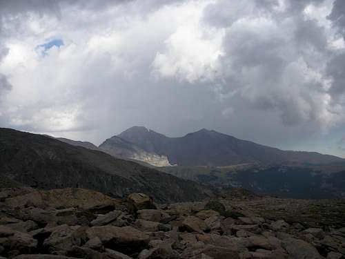
Fairchild Mountain
![Lawn Lake Trail]() Fairchild Mountain
Fairchild Mountain
I won’t try to bore you with suspense. We didn’t make it to the summit of Fairchild. Chalk this one up to exercising poor judgment on the day of the hike.
After our all night drive on Friday, and then 10 plus miles of hiking on Saturday we chose to sleep in. We definitely needed the rest, but this meant we would be getting a late start on Sunday morning. Despite this, when we rolled out of the tent and started discussing our possible hiking destinations for the day, I decided that we would try to hike up Fairchild Mountain. With an 8.75 mile approach and 4,962 feet of elevation gain, we should have saved this hike for another day. But the beautiful weather we had on Saturday was also forecasted for Sunday. Two straight cloud free days in RMNP! Maybe the afternoon thunderstorms wouldn’t come? My instincts said “No Chance”. I chose to ignore my instincts.
We ended up at the trailhead after 7 AM. It was a beautiful day and the skies still looked good by the time we reached Lawn Lake, so we headed towards The Saddle.
![Lawn Lake Trail]() Longs Peak from Lawn Lake Trail
Longs Peak from Lawn Lake Trail![Lawn Lake Trail]() Lawn Lake
Lawn Lake
Any thoughts of attempting to summit Fairchild were shot down when we approached The Saddle. A gentle rain started to fall. It was now approaching noon, and my initial fears were realized as the chance for afternoon thunderstorms were very real. As we were so close to The Saddle we decided to give that a shot and quickly climbed up.
![The Saddle]() From The Saddle, watching the clouds roll in
From The Saddle, watching the clouds roll in![Lawn Lake]() From The Saddle, the view down to Lawn Lake
From The Saddle, the view down to Lawn Lake
By the time we reached The Saddle the rain subsided, but we had to decide what to do. Rob was tired, as much from the climb as from the all night drive the day before. If we were going to try for a summit bid he said he had to first take a nap. I looked at the clouds coming in from the west, looked at the 1,100 feet we still had to climb to get up Fairchild and decided we would be better off descending. Rob agreed and without much hesitation we started our descent. Fairchild Mountain would have to wait for another day.
Andrews Glacier
From the day Rob and I started planning this trip, we had a loop hike with Andrews Glacier on the itinerary. Our goal was to hike up the glacier, take a long walk on the Continental Divide, and descend via Flattop Mountain Trail. Unfortunately we never made it up Andrews Glacier. Our lack of success was due primarily to the fact that we relied too heavily on one trail book for our research. The fact that we had no experience climbing up a glacier didn’t help. Our trail book talked about how people slide down the glacier. We figured, if people can safely slide down it, then we should be able to walk up it. I wasn’t real sure about this, so prior to the trip I did try to find more information about climbing the glacier, but wasn’t successful.
There was a negative tone in the air before we even left for the trailhead that morning, and this had to do with our hike on Saturday. When we took our little side jaunt on the trail to Andrews Glacier we ran into a solo hiker who had just come down the glacier. “It definitely wasn’t the safest thing I’ve ever done”. This statement would weigh heavy on Rob and me for the next 36 hours. Besides that, a park ranger told us that people generally didn’t try to climb the glacier this late in the year as crevasses would open up. Based on all of this information I convinced Rob that if it wasn’t safe to climb it, we could at least attempt to climb around the glacier.
![Loch Vale]() Sunrise over The Loch
Sunrise over The Loch![Andrews Glacier]() On the trail to the base of the glacier
On the trail to the base of the glacier
We were not disappointed with the beauty of Andrews Tarn and the glacier. Just reaching the base of the glacier made the whole hike worthwhile! But now we had to decide how to get up it. Were we going to just try and walk up the glacier itself or try to do some route finding and scrambling to skirt around it? I took a few steps onto the snow and didn’t feel comfortable. Rob didn’t have any interest trying the snow so we decided to stay on the rocks and we tried to go to the left on the way up. After some very fun scrambling and route finding we eventually reached a point where we either had to cross very steep snow, or we had to try some very steep climbing. At this point Rob said enough was enough.
![Andrews Glacier]() End of the line for us
End of the line for us![Andrews Glacier]() Looking down to Andrews Tarn
Looking down to Andrews Tarn
I half heartedly tried to convince him that we could try some of the steep rock, but he wanted nothing to do with that idea. So we decided to turn around once again. It was undoubtedly the safe and smart move, but still, with how close we were to the top of the glacier I was disappointed. Another year perhaps - with an ice axe!
The Continental Divide
![Hallett Peak]() Hallett Peak
Hallett Peak
This would be the day we screwed up in reverse, by getting such an early start.
We actually didn’t have a specific final destination planned for this day. We just wanted to get up to Flattop Mountain and then hike along the Continental Divide. There wasn’t a peak bagging agenda, although we figured we would get at least two peaks. Maybe Hallett and Taylor, or possibly Powell Peak! Who knew! We were getting an early start so we would just see what the day would bring.
We were out of the tent early, probably around 4 AM, and headed to Bear Lake Trailhead. There was a lunar eclipse that morning so we planned our start time around being able to see the eclipse.
We headed up Flattop Mountain Trail, and neared the summit of Flattop around sunrise. The sun rising in the east was beautiful, but the view to the west wasn’t so nice. Fog! And plenty of it! We reached Flattop and couldn’t see across it as the fog just rolled over the Divide, and continued to do so all morning.
![Flattop Mountain Trail]() The fog rolling over The Continental Divide
The fog rolling over The Continental Divide![Flattop Mountain Trail]() Longs Peak as seen from near the summit of Flattop
Longs Peak as seen from near the summit of Flattop
Since we couldn’t see the mountains, and it was so early, we figured we would be able to wait out the fog and allow the morning sun to burn it off. Unfortunately, between the fog and the wind, it was quite cold sitting on the divide, so we dropped over a hundred feet on the trail and hid behind a rock outcropping, for what ended up being well over an hour. The fog was relentless, but after a while it did appear that it might clear up some so we decided to try for Hallett.
We made it to the summit of Hallett and couldn’t see past our noses. Since the fog hadn’t let up for over two hours we decided that maybe once again, today wasn’t our day. So we headed down the mountain.
![Hallet Peak]() Rob on the approach to Hallett
Rob on the approach to Hallett![Hallet Peak]() The summit of Hallett Peak
The summit of Hallett Peak
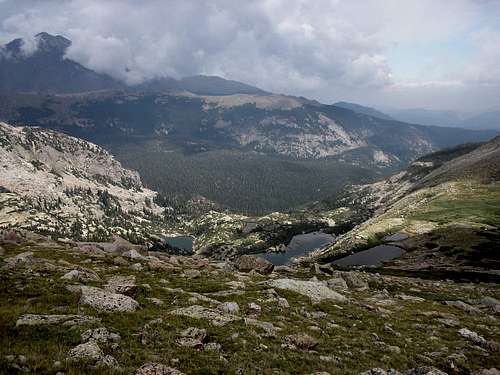
Fortunately the skies cleared as we descended, and I now realized how I had forgotten how beautiful the hike is down Flattop Mountain Trail.
![The Mummy Range]() The Mummy Range
The Mummy Range![Flattop Mountain Trail]() Glacier Gorge
Glacier Gorge
While maybe we didn’t get to spend the day hiking along the Divide, we were getting great views of The Mummy Range and of Glacier Gorge. The great views on the hike down made the day, and helped keep us from being too disappointed.
Isolation Peak
Beyond the shadow of a doubt, this would be the most adventurous and most memorable day of hiking I had ever experienced. Every time Rob and I start to talk about this hike, we chuckle and shake our heads at the same time, and affectionately refer to it as Isolation Peak Day. I could write a separate trip report just for this hike, and maybe I will someday, but for now I’ll just give the Reader’s Digest version.
We woke up early and were at the Wild Basin Trailhead before 4 AM. It was a perfectly clear morning so we were able to hike a good portion of the time by moonlight, versus using our headlamps. By the time the sun was coming up we were well past Ouzel Falls and on our way up the ridge towards Ouzel Lake. At this point I was able to stand in the one spot and take a picture of the moon setting over Wild Basin, turn 180 degrees and take a picture of the sun rising in the east over Wild Basin. Rob said at that point that this one event made the day, and anything else would just be gravy.
![Wild Basin - RMNP]() Sunrise over Wild Basin
Sunrise over Wild Basin![Wild Basin - RMNP]() The moon setting over Wild Basin
The moon setting over Wild Basin
We continued on and headed towards Ouzel Lake. Considering how long a day we had in front of us I suppose we should have bypassed this short side trip. But I had been to Ouzel Lake two years before and knew how great the view was. Besides, I also knew that we could do a short scramble through a marshy area and climb over some downed trees and get right back on Bluebird Lake Trail. While Rob really liked Ouzel Lake, he wasn’t real thrilled with the soggy off road hiking back to the trail.
![Wild Basin - RMNP]() Ouzel Lake
Ouzel Lake![Wild Basin - RMNP]() Bluebird Lake
Bluebird Lake
We continued on to Bluebird Lake, stopped for some lunch, and this is about the time the day became adventurous. As we stood on the shore of Bluebird, looking across towards Ouzel Peak, Rob and I began to disagree on the best approach. After much debate, Rob decided to go left at Bluebird Lake and I decided to go right, and we agreed that we would meet on the other side. Getting to the other side was quite an adventure for Rob as he cut his foot when he waded through the lake, but eventually we did meet on the other side. We then proceeded on to Lark Pond and then Pipit Lake and started making our approach to the saddle between Ouzel Peak and Isolation Peak.
![Lark Pond]() Lark Pond
Lark Pond![Wild Basin - RMNP]() Pipit Lake
Pipit Lake
After we passed Pipit Lake Rob started to get nervous about climbing up to the saddle. From a distance the climb looked pretty steep. I was starting to get nervous for a different reason - that for the fourth day in a row we weren’t going to reach our goal. To coax Rob into continuing on, I picked out what looked like a green bush on the low end of the slope. I asked Rob if he felt he could make it to that point. He agreed that he could, so we continued on. Once we got to this “green bush” I found another point of reference and asked Rob if he could make it there. He said he could. We proceeded on this way until we neared the summit of the saddle. The last 50 vertical feet were a little more challenging but we finally made it.
![Wild Basin - RMNP]() Isolation Lake
Isolation Lake![Isolation Peak]() Rob, finally up to the saddle
Rob, finally up to the saddle![Wild Basin - RMNP]() One of several false summits
One of several false summits
From there it was a long climb past several false summits until we reached the final approach to Isolation Peak. I climbed on ahead of Rob and reached the summit first. Once there I was shocked at the exposure as there was a straight drop on the other side of the peak. I warned Rob as I knew he would be nervous with the exposure. Several minutes later he made his way to the top. While I chose to sit on the summit rock, Rob chose to just slap his hand on it and call it good.
![Wild Basin - RMNP]() The view towards Mt. Alice, Chiefs Head and Longs Peak
The view towards Mt. Alice, Chiefs Head and Longs Peak![Wild Basin - RMNP]() The view down to 5th Lake
The view down to 5th Lake
Unfortunately we didn’t get to enjoy our summit experience for very long. Thunderheads were rolling in! So after spending many hours getting there, we spent a total of about 10 minutes on the summit, and started making our way down.
![Wild Basin - RMNP]() Thunderstorms rolling in over Longs Peak
Thunderstorms rolling in over Longs Peak
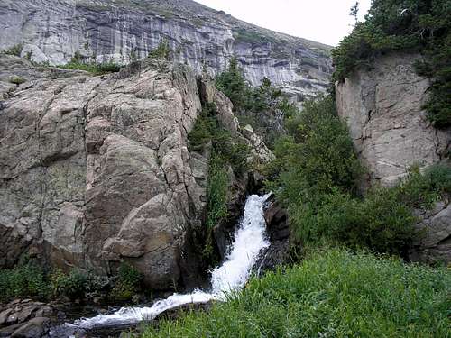
We were attempting a loop hike and would be descending via Thunder Lake Trail. As we descended to the saddle between Isolation and Mahana the afternoon thunderheads rolled in. We had a great view of a direct lightning strike near Longs summit. As we descended we unfortunately made a poor decision and started descending towards Eagle Lake too soon, so we ended up on the wrong side of the lake. This required us to do a lot of bushwhacking to try and get to Box Lake. After a lot of frustrating scrambling we made it down to Box Lake and found the cairns that would lead us back to Thunder Lake Trail.
![Wild Basin - RMNP]() Heading down towards Eagle Lake and Box Lake
Heading down towards Eagle Lake and Box Lake![Eagle Lake]() Eagle Lake
Eagle Lake![Falls Above Box Lake]() A beautiful waterfall near Eagle Lake that we stumbled upon while bushwhacking
A beautiful waterfall near Eagle Lake that we stumbled upon while bushwhacking
Unfortunately on the way out the fisherman’s trail we lost the cairns and spent quite a bit of time in the woods hiking along the stream. To make things worse, it started to rain and then the thunder and lightning came shortly thereafter, as we made our way through the woods. We continued to make our way back towards the trail and after over an hour in the woods, we were finally back on Thunder Lake Trail. To say we were happy to be back on a real trail would be an understatement. We continued on in our soggy boots and made it back to the car at the Wild Basin Trailhead. After the stress of the day we stopped at Mary’s Lake Lodge for a few beers and supper to help us unwind. We needed the break, to say the least.
It was a long day, but a great day. The most memorable day of hiking I have ever had. And it’s called Isolation Peak for a good reason. After 15 hours on the trail, we literally saw no one the entire day.
Spectacle Lakes
Today was a rest day. I say that somewhat sarcastically as the hike to Upper Spectacle Lake is over 5 miles long with 2,820 feet of elevation gain. But after our long hike to Isolation Peak we decided to sleep in and take it easy. We went into Estes Park for some breakfast and to just wind down. By mid morning though we knew it was time to hit the trail. Rob was really intrigued by Spectacle Lakes so we headed to Lawn Lake Trailhead.
I didn’t think we had much chance for success. We were getting a pretty late start and by now I was “the glass is half empty” guy. As we headed up the trail I was whining to Rob about the late start and the good chance for thunderstorms. He was unfazed. But by the time we made it past Ypsilon Lake we could hear the thunder far off in the distance.
![Ypsilon Lake Trail]() Chipmunk Lake
Chipmunk Lake![Ypsilon Lake Trail]() Ypsilon Lake
Ypsilon Lake
With the steepness of the trail after Ypsilon Lake, the hike ended up being a lot of fun. We had read about the rock climbing needed to get up to Spectacle Lakes and particularly one tricky move that trail hikers like ourselves wouldn’t be comfortable with. And this is where the hike came to a halt. We tried quite hard to get up the rock climb, but with our limited experience on this type of terrain we were having some troubles. And this time the tables were turned. For most of the trip I had been the one pushing Rob past his comfort zone, but at this point I had to reel Rob in. I wasn’t comfortable trying to make this move. I was even more concerned about having to come down it if we were successful going up. After several minutes I convinced Rob to turnaround. The decision was made easier as it started to hail at about the exact same time he started down. Fortunately the hail only lasted a few seconds, but we knew at that point it was time to hustle down, and again, Spectacle Lakes would have to wait for another day.
![Spectacle Lakes]() End of the line for us
End of the line for usMt. Alice
If there was one hike on this trip where we wanted success, it was Mt. Alice. We stumbled across Mt. Alice the year before when we climbed up Boulder-Grand Pass. Rob became enamored with Alice so it became a focal point of our agenda. Our plan was to do a loop hike, and head up via Lion Lake and descend via Boulder-Grand Pass.
With the long approach of 9 miles and 4,810 feet of elevation gain we wanted an early start, and we got it! Rob’s alarm was set for 3 AM. When I got in the car Rob informed me that it was actually only 2 AM. It wasn’t his alarm that went off. What we heard was that sound his cell phone makes when the battery dies. We took off for Wild Basin anyway. Starting an hour early ended up being a great bonus. By the time we made it to Lion Lake No. 1 the sun was coming up and the alpenglow on Mt. Alice and Tanima Peak made for some outstanding views.
![Wild Basin - RMNP]() Alpenglow on Tanima Peak
Alpenglow on Tanima Peak![Wild Basin - RMNP]() Chiefs Head from Lion Lake No. 1
Chiefs Head from Lion Lake No. 1
It was at this point though when we started to wonder about our chances for success. We stood there in the early morning sunlight and became intimidated by the steep slope of Alice. We continued on up the ridge leading to the saddle between Mt. Alice and Chiefs Head. As we neared Alice, we became even more intimidated and I told Rob at one point that “If that is what we have to climb to get up Alice, then I’m not going!”
![Wild Basin - RMNP]() The ridge walk leading up to Hourglass Ridge
The ridge walk leading up to Hourglass Ridge![Mount Alice]() The moon setting over Mt. Alice
The moon setting over Mt. Alice![Hourglass Ridge]() Hourglass Ridge
Hourglass Ridge
We reached the saddle and made our way towards Hourglass Ridge. We probably wandered around the area for a good 30 minutes in a debate about whether to go across the ridge and begin the climb. Deep down we figured that if we went across, we would probably find that it was doable. As we had discovered on this trip, usually a climb looks much tougher from a distance, and that was probably the case here as well. But Rob was very tired and he worried about making a mistake on the climb. I was also intimidated and sarcastically said “I’d love to live to be able to tell my wife about our trip on Sunday.” Rob quickly replied “How about telling her on Saturday?”
At that point I knew it was time for us to head home. Our plan had been to get up early Saturday morning and hike out to Chasm Lake, to catch the sunrise and alpenglow on Longs east face, and then start our 20 hour drive home. But Rob was missing his three toddlers, so I agreed with him. By the end of our hike today, we would have covered over 90 miles of trail in seven days and had seen so much spectacular scenery. Why push it?
![Wild Basin - RMNP]() Lion Lake No. 1
Lion Lake No. 1![Continental Divide]() The view down the Continental Divide
The view down the Continental Divide
We stayed up on the saddle for quite a while taking in the views, with Chiefs Head in our sights and then being able to look right down the Continental Divide at McHenrys Notch all the way to Flattop. There was also a great view back into Wild Basin. This was now one of my favorite spots in the Park. I knew I would be back.
Afterthoughts
Hindsight is 20/20 and if I knew then what I know now I’m sure we would have had more success. I was limited at the time, and still am, by my lack of climbing skills. I am really more of a hiker than a climber. I also would have exercised better judgment, as for instance getting the late start up Fairchild Mountain. We relied too heavily on just one trail book so more extensive research prior to the trip would have helped. I did do some searching on the internet prior to the trip, but obviously it wasn’t enough.
But as for Mt. Alice, if I would have known about SP then, I know we would have made it to the summit. With the info on SP – the mountain page, trip reports, and member comments attached to those pages – I now realize that we would have been fine going up Alice. The climb was within our skill level! Alice just looked more intimidating than it obviously is. But with the information we had at the time, all we could do was go with our instincts. And our instincts told us to turnaround.
I am by no means an expert, but regardless of one’s experience level, being able to objectively access a situation may be one of the most important traits to have when you hit the trail. Knowing when to say when! It definitely kept Rob and me out of a lot of potential trouble. Five out of seven times we were willing to turn around rather than push our safety boundaries. Maybe some of our decisions were too conservative. That may be true, but we returned safely home, to hike and climb another day. So, no regrets!


Comments
Post a Comment