
-
 7247 Hits
-
 83.75% Score
-
 18 Votes
|
|
Mountain/Rock |
|---|---|
|
|
43.54020°N / 103.5203°W |
|
|
Custer |
|
|
Hiking |
|
|
4430 ft / 1350 m |
|
|
Overview

The south side of Fossil Ridge

Black Ice Cave

Fossil Ridge formation in rock

Wind Cave National Park Prairie Dogs
Fossil Ridge is an unranked summit in the Black Hills, and is located in Wind Cave National Park, along the western boundary. The summit can probably be best enjoyed as part of a hike on the Cold Brook Canyon Trail. Situated about 240 feet above the canyon floor on the southern edge, the summit provides great views to the south and west. Battle Mountain, to the southeast, is the easiest summit to identify from Fossil Ridge. There are no trails up from Cold Brook Canyon Trail, so hikers will have to create their own route up the mostly open southeastern slopes. It is a fairly easy scramble up from Cold Brook Canyon Trail, taking probably no more than 10 minutes (unless you are taking lots of photos).
Wind Cave was formed in the Madison Limestone formation (also called Pahasappa Limestone in the Black Hills), so small caves are numerous along the canyon, in the high limestone walls, and at the base of the walls. As is the case throughout much of the national park, fossils are found here. Please remember it is illegal to remove these.
Fossil Ridge Cave, located nearby, was mapped in 2000. It is relatively small, with a 30-foot passageway that enters into a domed room. Black Ice Cave (one of several caves bearing that name in the Black Hills) is located along Cold Brook, just west of the park boundary fence. According to park employees, Black Ice Cave is rather unique, in that at least one of its branches actually descends down to an aquifer below. It is unknown yet, if any of the cave branches intersect with any Wind Cave passages.
Cold Brook is an intermittent stream, with small springs located at some of the bends. It is rare to have to wade when making any of the trail crossings over the brook. Considering the drainage area of the canyon (which includes the Antelope Canyon branch just upstream), hiking here right after a major downpour could put one at risk for a flash flood.
Area wildlife commonly seen in the Fossil Ridge area, include bison, elk, deer and prairie dogs. However, there are significant numbers of pronghorns, coyotes, rabbits, and porcupines as well. Rattlesnakes are always a risk from April to late fall. Mountain lions are seen in the area sometimes, though they tend to be reclusive. Eagles can sometimes be seen circling high above and along the canyon walls.
Getting There & Routes
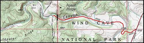
Fossil Ridge Routes Map
There are two basic approaches to Fossil Ridge. Since many hikers are also interested in seeing Cold Brook Canyon, fossils, wildlife, and sometimes the caves, they will have to decide if they want to access Fossil Ridge on the national park side or the national forest side.
Eastern Approach: The Cold Brooks Canyon Trail in Wind Cave National Park provides the route from the east to reach Fossil Ridge. The Cold Brook Canyon Trailhead is 8.7 miles north of Hot Springs, along Highway 385 in Wind Cave National Park. The trailhead is 1.8 miles north of the park entrance. The trail winds down through some trees to the floor of Cold Brook Canyon, and mostly follows the canyon floor for 1.4 miles to Fossil Ridge. This is an easy hike, but be on the lookout for bison in the area. Watching for rattlesnakes is also important.

Trailhead Welcoming Committee
Western approach: For those who prefer to access Fossil Ridge from the west, go 2 miles north of Hot Springs on Highway 385, and turn west on Argyle Road. The road will take an overall northwesterly direction. After traveling 6.3 miles, you will come to Song Dog Road (Road 682.1). Turn north on Song Dog Road and travel north 4.7 miles. You will arrive at Cold Brook Canyon. This is national forest service land. There is a short, faint road along Cold Brook on the right. It goes down to the fenced western boundary of Wind Cave National Park. The gate is chained and padlocked shut. There are no posted restrictions against climbing over the fence, and you will need to scale the fence to access the southeastern slope to bushwhack to the summit. The 7-foot fence serves to keep the bison and elk in the park. The gate is opened seasonally to allow elk to migrate out. The process for allowing the elk out, without the bison going with them is unknown to me.
Red Tape

Western Boundary Fence
There is not much red tape to access Fossil Ridge. Those who do not want to camp in designated campgrounds will need to camp on the national forest side. The Black Hills have experienced some pretty serious fires in recent years, so be assured that fireworks and campfire restrictions will be enforced. Removing fossils and rocks from public lands is prohibited. There are some firearm restrictions in the national park. For the latest updates and information on regulations, check these resources:
Wind Cave National Park (605) 745-4600
National Forest Service Office in Hot Springs (605) 745-4107
National Forest Service Office in Custer (605) 673-9200
When To Climb

Spring blossoms at the summit

The Cold Brook Canyon Trail
The park is open year around, but heavy snow in the winter can make access difficult. This is especially true for those who wish to access the summit from the west side, via forest service road 682.1. Sometimes it takes quite a while for this road to get cleared of heavy snow.
Summer lightning and hail will also be a consideration. For the latest weather forecast and conditions, click here:
Wind Cave National Park Weather
Camping

Fossil Ridge view southeast
Wind Cave National Park and Hot Springs offer the closest camping opportunities. But, travel from Custer is not that much further. The chamber of commerce offices in each town keeps up to date lists of camping and lodging resources. Listed below are some resources that may be helpful to you:
Wind Cave National Park Camping (605) 745-4600
Cold Brook Lake Campground
Hot Springs Chamber of Commerce (800) 325-6991 (605) 745-4140
Custer Chamber of Commerce (800) 992-9818
Maps
The Black Hills South map, published by National Geographic, is an excellent map for the area. If you are exploring any of the national forest lands in the area, either of their offices in Hot Springs or Custer offer a free Motor Vehicle Use Map for the Black Hills National Forest.