July 24, 2009
My 12-year old son and I set out to climb Kings Peak and Gilbert Peak over the Pioneer Day holiday weekend. We set out from our home in Salt Lake City on the morning of July 24, 2009, heading (partially) in reverse on the trail that the early settlers followed into the valley 162 years ago that day. We followed I-80 eastward to Fort Bridger, Wyoming, and gassed up in the small town of Mountain View. From there we headed south on WY-410, following the directions set out on the outstanding SP pages for both Kings Peak and Gilbert Peak. We reached the Henrys Fork trailhead about three hours after leaving Salt Lake. The roads to the trailhead are very well maintained and the trailhead is usually easily accessible by passenger car.
At the trailhead, it was a zoo. Both parking lots were completely full, and people were parallel parked on both sides of the road for about a half-mile back down the road. We found a place to pull our car into off of the side of the road under a tree. After taking a few minutes to gather our gear, we soon were headed up the Henrys Fork trail with full packs on our backs. The day was sunny and the trail was busy, with many groups day-hiking in to Alligator Lake to fish, and many other groups headed out of the wilderness. Among other groups, we passed two full troops of Boy Scouts who told us that they had summitted Kings Peak the day before. I had heard that this trail gets a lot of use, and we found that to indeed be the case.
The trail is well-maintained and easy to follow, as it gradually rises through the forest, with the creek always on the left side for the first few miles. After about 5 miles we came to Elkhorn Crossing and crossed the creek on the log footbridge. From there it is another couple miles into the Henrys Fork basin.
We were able to keep a good pace and reached Dollar Lake about 3:00 p.m., about 3 1/2 hours after leaving the trailhead.
We soon found a great little campsite on the northern side of Dollar Lake, and quickly set about erecting our tent, because the skies had begun to darken and we could hear thunder in the vicinity. I had decided to pack in the larger 3-man tent, even though there was only two of us, and this turned out to be a wise move, because we ended up spending a lot of time in it and it was nice to have the extra room. Anyway, just a few minutes after we finished setting up the tent, the heavens opened and it started to rain hard. We spent the next couple hours largely hunkered down in the tent, as the rain fell pretty consistently for quite a while. It took us a while to get the rain fly properly situated and the drips into the tent stopped, but soon we were as snug as could be expected. The lightning and thunder throughout the afternoon were quite loud and severe, and I wondered if anyone was actually up on the peaks during the storm.
While we were in the tent we set up our sleeping gear, and the trip got off to an inauspicious start when I realized that I had a giant hole in my Therm-A-Rest that looked suspiciously like the claws of a cat. We tried a makeshift repair job that ultimately turned out to be unsuccessful, so I spent some time that afternoon getting used to the hard ground and psychologically resigning myself to two nights on a "mattress" with no air in it. It did, however, make me feel slightly better to call my kids' cat unflattering names.
The thunder and lightning finally stopped later in the evening and we were able to cook some dinner. I wondered if we would really be able to bag Kings the next day, given all of the thunder and lightning in the area. We resolved to get a very early start the next morning.
July 25, 2009
The alarm went off at 4:20 a.m. It was still pitch dark. I crawled out of the tent to see whether I could see any stars, and I couldn't see many. It had rained some throughout the night, but not for the last couple hours, and so we decided to give Kings a shot, or, at least, to hike until we heard thunder. We cooked some oatmeal in the dark in the vestibule of the tent, and we were off for Kings at 5:25 a.m. It was still dark enough for headlamps.
The trail up past Dollar Lake toward Gunsight Pass is a good, gradual trail that is easy to follow, even in the dark, and we made good time. About 6 am we were able to turn off our headlamps and better assess the weather. The sky was fairly solid clouds, but the peaks were still clear and it was not raining. Given yesterday's weather, and given the fact that it was already cloudy, we knew thunderstorms were inevitable, and might even arrive before noon, so we knew we had to hustle if we were to bag Kings on this day. So we kept pushing the pace.
We made it to Gunsight Pass at about 6:40, and took a quick break.
As we sat there, we could easily see the cairned contour-traverse, established by hiker use, that wound its way around West Gunsight Peak and up a cliff-band on its southeast flank. We had heard that this was tbe best of the three options for hiking Kings, and we decided to give it a go, as we couldn't see any point in hiking down into Painter Basin and back up again, and we didn't want to climb the Anderson Pass chute. Anyway, the cairned trail for the contour-traverse begins immediately from the top of Gunsight Pass, and heads off to the right (west). The trail is easy to follow for the first quarter-mile or so, and then the cairns start becoming harder to find as the trail gets steeper through the cliff bands. At one point we lost the trail and just headed upward through the rocks, scrambling with our hands as necessary. Later, on the way down, we learned that if you stay to the left (going up) the going is easier.
Once we made our way through the cliff-band and to the top of the ridge, the next mile or so is an easy and pleasant traverse over a grassy ridge and down into the basin leading up to Anderson Pass. There is a massive cairn on the edge of the slope going into the Anderson Pass basin that makes a nice landmark on the return trip. From there it is a simple but tedious matter of boulder-hopping one's way across the fairly level basin to Anderson Pass.
When we reached Anderson Pass the weather was starting to worsen slightly. The clouds were lower now and were now spitting rain, and it was not quite 8:00 am. We met a couple at the base of Anderson Pass and we chatted about the weather, and whether a summit attempt was even wise. But neither of us had heard thunder yet, and so we resolved to continue on. There is a nice trail up the slope to Anderson Pass, which is the lowest point on the summit ridge.
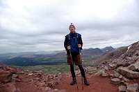
From Anderson Pass the route to the summit turns south and heads up the craggy summit ridge, where there is no trail to speak of. The route requires negotiation of a steep rock field, hopping from boulder to boulder and climbing steadily. It wasn't raining hard, but there was enough moisture to make the rocks slick and hard to gain steady footing on. Because we were still worried about the weather, we took only a quick rest stop at Anderson Pass and continued on up the ridge. We saw another six or seven people on the summit ridge, heading down as we were heading up. They must have gotten up VERY early to get there before us. We finally reached the summit at 8:30 am, three hours and five minutes after leaving Dollar Lake.
We were exhausted, and the weather was cold and spitting snow, and so we only allowed ourselves about five minutes of exhilaration on the summit. It was a fantastic feeling to stand there on the roof of Utah after a difficult final push to the summit.
We quickly turned around and headed down, and reached the bottom of the cliff-band on the contour-traverse without incident. We had passed quite a number of people heading up the trail as we were headed down, and some of them did not look very well equipped for the hike. We wondered if all of these people would make it to the summit (and back) without any problems. By the time we reached Gunsight Pass, my son was having a rough time, his head hurt and he was feeling queasy. So we started to slow our pace now that we were off the high ridges. The skies were darkening, and about a mile before we got back to Dollar Lake the heavy rains came, accompanied by thunder and lightning. We put on our rain gear and kept plodding along, but by the time we got back to our tent we were both pretty wet and cold and flat-out exhausted from our quick "sprint" to the summit. It was 12:25 pm when we got back to our tent, almost exactly seven hours after we left it.
We had no plans for the afternoon, and it was a good thing, as we both needed some down time to recover from the hike. It rained off and on throughout the afternoon anyway. There were a few moments of brief sun that allowed us some time to get out of the tent and enjoy the scenery around Dollar Lake for a few minutes before the next band of rain. At one point two US Forest Service Wilderness Rangers visited our campsite to destroy the fire ring that previous campers had left there. While doing their work, they told us of a nasty mess of trash and human waste that a Boy Scout troop had left in a meadow just south of Dollar Lake the day before. The rangers were none too happy about having to clean up the mess, and had no kind words for the Boy Scout troop.
As we cooked dinner that night we discussed whether we felt up to attacking Gilbert Peak the next morning, and we decided that after an entire afternoon of rest and recuperation in the tent we were going to give it a go. We fell asleep that night with dreams of bagging another Utah county highpoint in our heads.
July 26, 2009
The alarm went off at 5:00 a.m. It was still dark, but I could already tell that the weather was going to be better than yesterday. I could see a lot of stars and there was no wind. It just felt like a great morning. Again we cooked oatmeal in the dark in the vestibule of the tent, and got ready to hit the trail.
We were off at 6.00 sharp.
In sharp contrast to Kings Peak, Gilbert Peak has no established trail to its summit, and is climbed by relatively few hikers, even though it is only 86 feet lower than Kings. The route from Dollar Lake to Gilbert Peak is much shorter and steeper than the route to Kings. The trip reports say that the route is only about 2.75 miles each way, although after completing the hike I would say it is closer to 3 miles after working one's way back and forth through the rockfields near the summit. Anyway, the route calls for a traverse around the north end of Dollar Lake through the forest and up the ridge just east of the Lake. This ridge is forested for a quarter mile or so, and then the trees give way to shrubs and then grasses. The ridge is very steep for the first mile or so, but is always grassy with solid footing.
The weather was much better than it had been the day before, and so we had no need to try to outrun the weather. So we resolved to take it much slower than we had the day before, so that we would not need a long recuperation period before hiking back to the trailhead. At our new and slower pace, it took us almost exactly one hour to negotiate the one-mile steep trudge up the ridge east of the lake. The ridge is too steep in most places to go straight up, so we switch-backed back and forth up the ridge until reaching the top.
The sun was rising, bathing the entire western side of Henrys Fork basin in a warm glow. It was a beautiful sight to behold and made the steep climb much more pleasant.
At the top of the ridge, the route calls for a 90 degree turn to the left (east) and up the far-flung west spur of Gilbert Peak. The going here is quite easy for the next mile or so. The route is mostly grassy and fairly easy going. The peak itself looms directly to the east, and looks like a huge pile of rocks. The high point is on the eastern edge of this big pile of rocks, so the summit itself cannot be seen at this point.
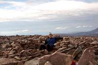
We just kept making our way up the northern side of the big rockpile, trying to stay on grasses and flowery spots as much as possible to avoid having to boulder-hop. This is manageable in most places, but in some spots boulder-hopping is inevitable. Eventually, we reached the summit of Gilbert Peak and found the lightning shelter and the benchmark.
![Gilbert s Benchmark]()
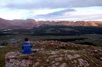
We hadn't seen another soul on the entire route (as opposed to the relative crowds of people we had seen on the Kings Peak trail the day before). We had the entire summit area to ourselves, and the morning was a glorious one, and so we spent about 30 minutes on the summit enjoying the outstanding views. Kings Peak is visible 3 miles to the southwest, and the view to the east into the rising sun was very impressive. The view to the north is completely unobstructed, allowing views far into Wyoming. I pulled out my cellphone to check the time, and lo and behold I had three bars, and so I called my wife and chatted for 5 minutes and told her that we were doing great. The connection was flawless, causing us to wonder how we could have spotless cell service at 13,442 feet in the middle of the High Uintas Wilderness Area and yet have no cell service in some spots in the Salt Lake valley. Anyway, we had reached the summit at 8:30, exactly the same time as we had summitted Kings the day before.
![On Gilbert Peak]()
After about 30 minutes, we headed down, again keeping a very steady but sane pace. The hike down is steady and gradual and, once you leave the high rockpile, mostly grassy and pleasant. Again we noted the contrast between the Kings hike and the Gilbert hike. They are night and day different, with Gilbert being by far the more pleasant and enjoyable hike of the two. The pleasant hike down, coupled with the fact that we had just bagged our 24th (out of 26) Utah County highpoints, put us in a chipper mood, which got even cheerier when we saw a beautiful bull moose in the forest just before reaching Dollar Lake. We got back to our campsite at 10:30 am.
After taking a long lunch break, we struck camp and loaded our packs for the 7 1/2 mile pack out. We headed downward at about 11:30 am. The hike out was largely uneventful, except for one thing: along the trail, we started noticing blood in the puddles, and it was clear that a horse on the trail ahead of us had a fairly severe wound. About halfway down, about a mile past Elkhorn Crossing, we saw a man sitting morosely on the side of the trail. He asked us if we had seen the Wilderness Rangers, and we said we had: they were about 10 minutes behind us on the trail, headed down, with 2 llamas. He said he needed their help because his horse was "bleeding to death." Sort of shocked by this, we looked around, and noticed a beautiful brown horse, with wild eyes, lying in the meadow a few yards off the trail, trying to raise its head but clearly not able to do much more than that. The man explained that the horse had cut an artery in its leg and that he had tried to bind it but had failed to stop the bleeding. I asked if there was anything we could do to help and he said there was nothing he or we could do. So we wished him luck, told him we were sorry, and continued on. We wondered if the horse really would die and, if so, how they would retrieve the body from beside the trail in a wilderness area. The whole episode with the horse sort of put a damper on what had been a fantastic day.
Anyway, the weather held all the way down, and we reached our car at 2:30 p.m. In contrast to the way the trailhead looked on Friday afternoon, the whole place was quiet, and there were only eight cars in the whole parking lot. Other than the morose horseman and the two Wilderness Rangers, we hadn't seen another person during the hike out. We wondered how the place could be so busy on a Friday and so relatively deserted on a beautiful Sunday afternoon. As we drove away, back toward civilization, we both agreed that it had been a fantastic and epic trip. We had battled the weather and fatigue and an airless mattress, and despite it all we had prevailed and had accomplished our goal of summitting both Kings and Gilbert.
Comments
No comments posted yet.