Kings Peak, UT, 13,528 ft. – September 2, 2006, HP #5 of the 50 US State Highpoints
I first heard about Kings Peak in August 2005 when I was climbing Chief Mountain in Glacier Park Montana. I was told it was a multiple day hike/climb to the highest spot in Utah. Since I was moving to Utah later that month, I decided then that I would climb that mountain. A little over one-year later, on a wind-free and sunny September 2, I found myself at 13,528 feet over looking the spectacular Henry’s Fork basin from the top of Kings Peak.
I had trouble falling asleep the night of Thursday August 31, 2006 as I anticipated, with both concern and excitement, what I was about to set out alone to do the following morning. Nonetheless, sleep finally came, and before I knew it morning had arrived and I was leaving Orem and on my way to the Henry’s Fork trailhead in the High Uintas. The 130 mile drive took me up Provo Canyon, through Heber, and past Park City where I connect up with I-80 and continued on into Wyoming. In Wyoming I drove past Evanston and exited at Fort Bridger then traveled through Mountain View, and into the Wasatch Cache National Forest of Utah. Around 11:30 AM September 1st, after almost exactly 3 hours I arrived at the Henry’s Fork trailhead from where the 30 mile round-trip hiking adventure would begin. No concerns remained as I ate a light lunch and double checked my loaded backpack. By 12:15 PM I was ready to go, and I asked a family, who were preparing for the same hike, to snap a hiking-opening picture of me. Then off, alone, I went on my three day adventure.
Most of the information I had read about the hike suggested walking in about 7 or 8 miles the first day and camping at Dollar Lake. I knew the trail was relatively flat up to Dollar Lake and possibly even a mile or two further to the base of Gunsight Pass where the hike would leave the basin and begin the real ascent into the Uintas Mountains. Anticipating a strenuous day two, when I would actually climb to the peak, I thought it wise to cover as much of the flat ground on the first day as possible. As such, I hoped I would be able to find water and camping at the mouth of Gunsight Pass. I mentioned this idea to a couple of return hikers I encountered in the Henry’s Fork parking lot, and a second time to two return hikers I chanced upon on the trail. Both times I was told water and tolerable camping could be had at my day one goal.
Studying the trail, the night before, I had broken my first day of hiking into three segments or landmarks. The first landmark would be an intersecting trail to Alligator Lake about 3 miles into the hike. The next landmark would be another 2.5 miles further along where I would encounter the Elkhorn stream crossing. The final landmark, of day one, would be the base of Gunsight Pass about 9 miles into the trek. Imagine my pleasant surprise when only about 2 hours into my hike I crossed a return hiker and was informed that I was almost at the Elkhorn stream crossing; the going was so quick that I had disregarded the first intersecting trail I crossed as my initial landmark.
As I crossed the stream at my second landmark, I, for the second time, meet up with and passed a group of about four young men, two of who appeared to be in the military, and one young woman. At this same time I noticed a lone-hiker who was attempting to ford the creek rather then cross on the bridge lower down stream. I hurried on hoping to stay ahead, and out of sight, of the other hikers. After awhile I decided to rest in a camping area which on the return trip I learned was in sight of Dollar Lake. While I rested the lone-hiker past by, but did not notice me. Shortly after resting, I caught up with the lone-hiker resting and I asked him if we were near Dollar Lake. He said he wasn’t sure, and I then asked him to snap a picture of me with Kings Peak in the background. During this time the other group of hikers caught up to and past us, only to rest a few yards up the trail. As I approached them they asked me if I knew where Henry Lake was, I comment that I didn’t but that I believe we were opposite Dollar Lake, and this seemed to be confirmed as we all saw a man and a woman leave the trees opposite us. We were at the base of an incline at this point and I decided I would hike up the incline and then head left to see if I could see the lake. On my way up the hill I past two older men on their way down, and I asked them about camping near Gunsight Pass and about the location of Dollar Lake. They informed me of a small lake at the bottom of Gunsight Pass.
Near the top of the hill I left the trail and headed left hoping to spot the lake, but was disappointed to find the only thing over there were domestic sheep. Deciding I could find it on the return trip, I returned to the trail and headed toward Gunsight Pass, soon catching up with, and unintentionally surprising the aforementioned lone-hiker. We chatted about camping at the lake ahead, and I soon recognized him as the owner of a white pick-up I had over-taken on the gravel road leading to the trailhead. Soon after, around 5 PM, I spotted the destination lake and pointed it out to my fellow lone-hiker who was now trailing me. I remained on the trail planning to approach the lake on its south-side even as my fellow hiker began bush-whacking through the shrubs and marshy ground to the north-side of the unnamed lake. I explored the south-side of the lake finding the surrounding ground to be too moist for camping. Leaving my backpack I walked over to the opposite side and spoke with my fellow hiker who introduced himself as Charlie. I asked him if he minded if I also camped on this side of the lake and he seemed almost glad that I might do so. After chatting for awhile I learned that Charlie, who as likely in his late 60’s, was quite the avid hiker, having bagged the high points in 38 of the US states. Around 6 PM, I set-up my camp next to a rock and about 30 yards from Charlie who was bivying it.
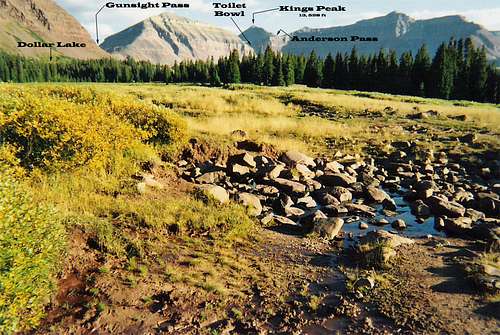
Once my camp was set up I turned my attention to cooking. For this trip I had brought along a couple of freeze dried dinners, instant oatmeal, and instant noodles, all of which could be simply and quickly prepared by adding only boiling water. The day before leaving on the hike I had bought a new Jett-Boil stove which claims to be able to boil one-cup of water in around one minute. For this meal I decided to cook freeze-dried beef stroganoff, and I had just finished adding the boiling water when Charlie stopped by. I ate and we chatted, and around 7 PM, we watched a group of two hikers set up across the marshy ground next to the trail; we expected they would come to the lake for water, but they never did. Just before dark we climbed a hill west of our camps to look over the Henry’s Fork basin. From this point we watched a cowboy on horseback, and his three dogs, round up and drive the domestic sheep toward the toilet bowl. The toilet bowl is a 1000 ft high and 0.25 mile long scree covered chute next to Anderson pass which is often used as a return trip shortcut by hikers who camp at Dollar Lake.
Henry's Fork Basin
Soon the sun was setting and each of us returned to his own camp. I sat on the big rock next to my tent for awhile and watched two hikers with flashlights walk by losing them as they entered Gunsight Pass. Around 9 PM I retired to my tent, but sleep avoided me and in its place came sickness. I believe it may have been the 11,000 ft altitude I was camping at as I was inundated with a headache on top of which the freeze dried meal, or possibly the iodine treated water, was not agreeing with my stomach. It wasn’t until after 1 AM that I finally feel asleep only to awake a couple of hours later due to wind and below freezing temperatures. Alas the cold was no match for my 27 year old, Northern Lights, down-filled mummy! Slightly before sunrise, around 6 AM, I woke-up, still with the headache and upset stomach, and decided to skip breakfast and begin the approximately five-mile, 2,500 ft climb to the top of Utah.
At around 7 AM as I started up Gunsight Pass I looked back toward camp and waved good-bye to Charlie who had emerged from his bivy. At the top of Gunsight Pass I rested and looked for a cairn marked shortcut I had heard about. Finding the shortcut I took it up and over two ridges where I spotted, from north to south, the top of the toilet bowl, Anderson pass, and Kings peak, below all of which was a basin that reminded me of pictures I had see of Everest. I soon realized I needed to descend down the ridge and into the basin, where I would pick up the main trail and head up Anderson pass. I no sooner began to do so when I saw four other hikers coming across the shortcut a bit east of me and heading down into the basin. I directed my path to intersect with theirs. Only one of the four seemed willing to talk but nonetheless I followed along with them for awhile to the bottom of Anderson pass where, around 8:30 AM, I paused for breakfast allowing them to go ahead of me. I was still feeling nauseated but I knew I needed to eat and drink so I braved down a granola bar and some beef jerky, and I drank some iodine treated water. At places a tiny stream shared the trail and it was still frozen solid at this time. As I continued on, I watched four hikers emerge to my right having climbed up the toilet bowl. Before I reached the top of Anderson pass the four hikers from the toilet bowl had started up the remaining one mile length and 900 ft altitude climb to the peak, apparently they were trying to catch the other four hikers I had encountered earlier.
With my upset stomach, and throbbing headache I made my own push to the top. At this point there was no trail to follow, only boulders and broken pieces of rock one had to hop to and from. I was unsure exactly where my destination lay so I tried to keep an eye on my predecessors but they soon disappeared behind one of the several false peaks. At one point I was so surprised I couldn’t see them that I called out “hello” hoping they would hear and answer, but to no avail. As I continued up, my headache increased with the altitude, and I felt a blister developing on my foot. At around 10:00 AM on a big boulder, which turned out to be only 200 ft from my goal -- although I didn’t realize I was that close -- I paused to check my foot, and to try to eat more. With the pause my stomach finally settled, and I was able to eat and drink more, while I applied moleskin to my tender foot. During this break two older men approached me and I asked them if they knew where the peak was, but they had the same question for me. I told them the four hikers I had encountered in the basin figured they would reach the peak by 11:00 AM, so we likely had another 45 minutes or more ahead of us, but of course that estimate was wrong and we were only 10 minutes from the objective. As I was ready to continue, down already came the eight hikers ahead of me, and from them I learn how close I was.
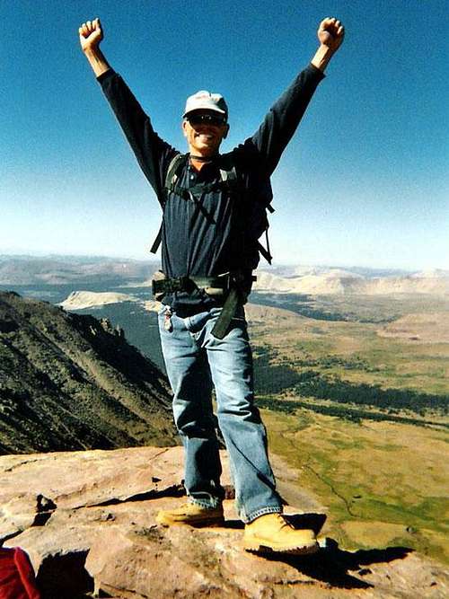
Up and on I went arriving at 13,528 ft at 10:30 AM Saturday September 2, 2006. I was greeted by the two older men I had spoke with a few minutes earlier and we all agreed what a nice surprise it was to have reached the top much sooner then we had anticipated. I asked one to snap a few pictures of me then off they went leaving me alone on top. Not long after two other climbers joined me staying only for a few minutes. Left alone again I searched the top for an elevation marker, which didn’t exist, when along came a man and women whom I recognized as the couple I had seen leaving the trees, the day before, where Dollar Lake was wrongly supposed to be. They asked me to snap a couple of pictures of them, and I had them take another of me.
On King's Peak Utah, September 2, 2006
I was in no hurry to descend so I relaxed and took in the views. To the east, on the left side was a basin, and on the right side a large lake (Lake Atwood). To the south was South Kings Peak at 13,308 ft (once believe to be higher than Kings Peak), and on the horizon endless mountains. To the west was a sheer drop off, a small basin, more mountains and a few high altitude lakes. To the north was the Henry’s Fork basin I had trekked up the day before in which I finally saw Dollar Lake off to the right, and Henry’s Lake to the west of that.
After a sunny and windless hour on the summit some teenagers arrived and I learned they were a part of a large group, so I decided to descend. Almost immediately I encountered several people on their way up, and one woman asked me where I was camped and then informed me she had seen sheep stampeding toward my camp. It took less than an hour to reach Anderson pass which now was cluttered with hikers In the basin at the bottom of Anderson pass I felt another blister coming on so I stopped to check it out. At this time the two hikers who were camped on the trail across from me came along, on their way back to camp. I informed them of the shortcut to Gunsight Pass and they decided to use it by sort of following me. Arriving at Gunsight Pass, a bit before 2 PM, I paused to rest as my followers continued on. As I started down the pass I crossed trails with a young man from Seattle who was hiking with a dog that was carrying most of his gear. He pointed out to me the clouds that had formed over the region I had left and I warned him of the potential for lightning. Near the bottom of the pass, I encountered a woman forest ranger on horse back with a pack horse. I asked her about the sheep, but she wasn’t helpful.
By 2:15 PM, I was back at my camp, and relived to find the sheep had not been around after all. First thing I did was to treat some water, then retire to my tent for a rest while the water purified. Around 3 PM, the water was ready, and so I prepared some food. Following eating, I again entered my tent for more rest, after which I planned to pack-up and hike down to Elkhorn crossing. While back at camp two other groups of hikers set up camps in the area, so I was glad my plan was to leave. By 5:30 PM, I was well rested, had my gear packed up, and was again on my way down.
After about an hour of walking, the blisters on my feet began to hurt and I was forced to stop and apply more moleskin. In bearable pain, on I went, arriving at Elkhorn stream crossing before sunset at 7:40 PM, relived to find the camp spot I had in mind was vacant. I quickly set up camp, tied my food up in a tree, and then noticed another tent, further in, hidden behind a group of trees. By 8:30 PM I was in my mummy bag and surprised that in the trees, and at a lower elevation, the temperature seemed colder than the previous night. For the most part I slept soundly for 12 hours, waking up only a couple of times, once as a flashlight passed my tent, and another time as the wind or an animal brushed my tent.
I spent the morning of the third day relaxing, airing out my tent and sleeping bag, organizing my stuff, and cooking food. Initially no one else seemed to be around, and I supposed the occupants of the other tent had headed for the peak early and that I had seen their flashlight in the early morning darkness. Perhaps around 11:00 AM, I noticed a man fishing in the creek, and I approached him to find he was a fellow I had briefly talked to just above Anderson’s Pass as I descend Kings Peak. He didn’t seem to remember me. He had caught a trout and placed it in water in a plastic bag.
Well rested, I packed up my gear, and patched up my feet, and began the remaining 5.5 miles back to my truck, leaving at 12:30 PM. About 45 minutes into the walk, my blistered feet began to hurt, and so at 1:30 PM I stopped to rest. I was hoping I was within an hour of the end at this point, but I had not yet past the Alligator Lake trail. Around 2:30 PM I crossed trails with my fifth group of hikers of the day, and they asked me where I had been and if I was alone, following my replies they told me I had only a half mile left. Physically I felt great, having no sore muscles and lots of energy but the blisters were a genuine hindrance, and so I was again forced to rest. At 3 PM, I was extremely glad to remove my shoes and socks and to put on my Birkenstocks having reached the end of my 30 mile adventure! Before I left I looked in the log book at the trailhead to see how many groups had logged in the same day as me. I counted 15 groups which amounted to 36 people. I could not have asked for a better trip, everything worked out flawlessly, and the weather was exceptional. Henry’s Fork basin is a beautiful, peaceful area, and reaching Kings Peak was a magnificent accomplishment.
Parents refers to a larger category under which an object falls. For example, theAconcagua mountain page has the 'Aconcagua Group' and the 'Seven Summits' asparents and is a parent itself to many routes, photos, and Trip Reports.


Comments
Post a Comment