Glaciers of Valtournenche Valley (Matterhorn - Monte Cervino)

Glaciers of Valtournenche Valley (Matterhorn - Monte Cervino)

Page Type Page Type: Area/Range
Location Lat/Lon: 45.88313°N / 7.62368°E
Sign the Climber's Log

Overview

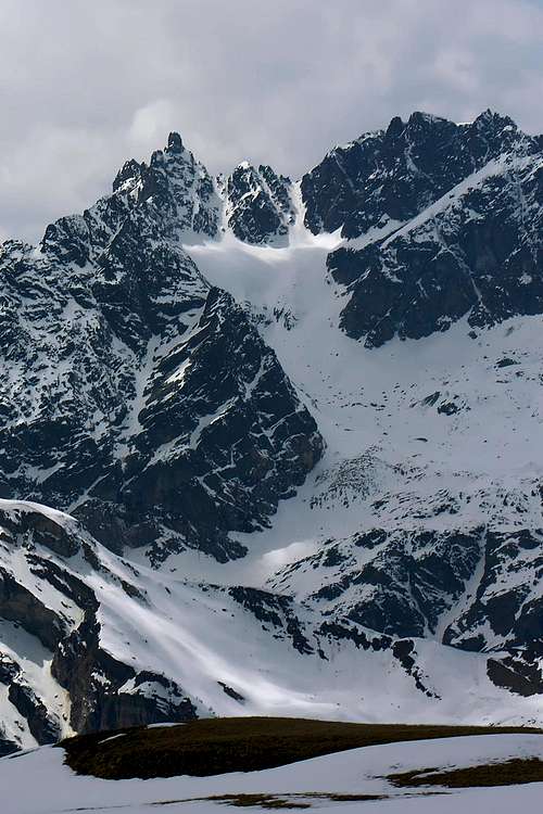
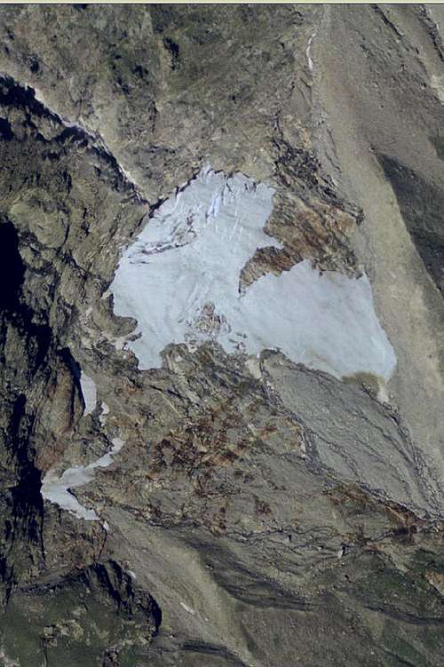
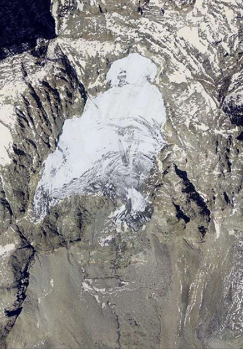
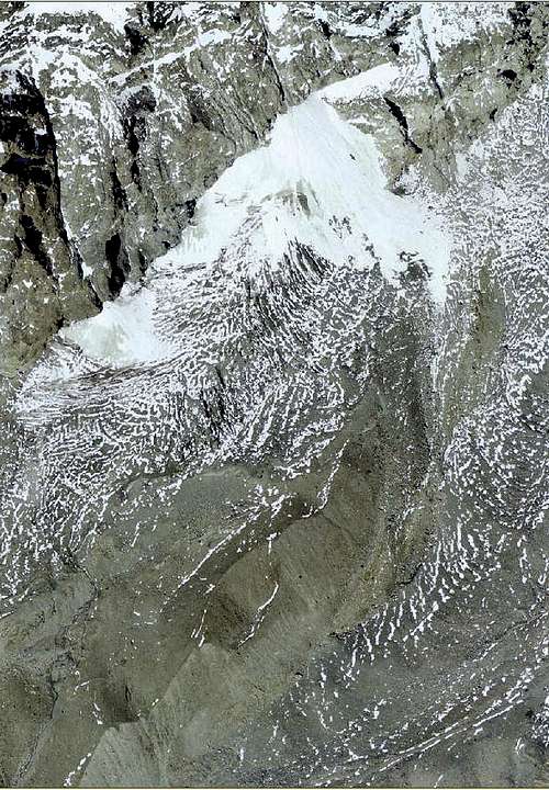
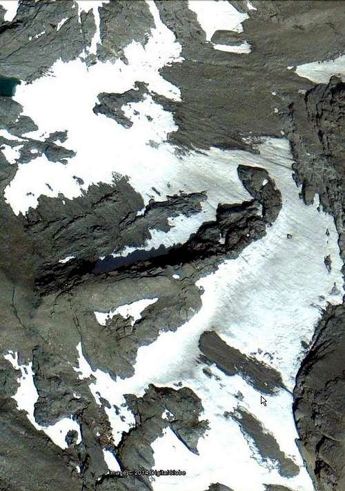
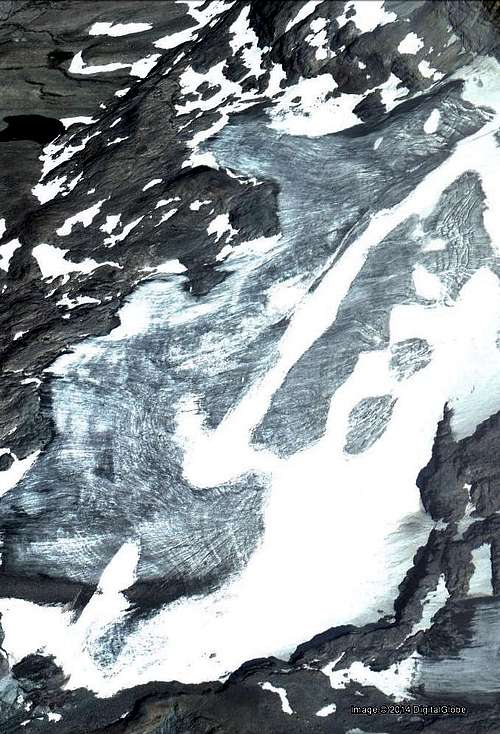
After the pyramid of the Dent d' Hérens at the height of Valpelline and at the end of the Chain of the Greats Murailles, opens the Breuil Conca (Basin), which stands at the top of His Majesty the Matterhorn. The Eastern slope of the Murailles not offer large expanses glacial and even offer the remnants of the glaciers at the base of "Gran Becca" incidentally is common knowledge that in the seventeenth and eighteenth Century until the Theodulpass you journeyed, by mule. And then there was still the "Greenhouse Effect". Yet already the ice retreated dramatically and only after the Klein Matterhorn and towards the Chain of Breithorns resumed to expand with great dimensions. It was, along with Lyskamms, the antechamber of Monte Rosa, the mountain, with its ice, dawn owns these colors, and that, even today, forward the suggestion of ancient ice ages. Then, descending to the South, all progressively disappear, "eaten" by the sun and, perhaps, the temperatures steadily rising. In fact, both watershed ridges that go down to the Central Valley of Baltea suitable to delimit the Valtournenche separating those of Valpelline and Saint Barthélemy (to the West) and the Ayas Valley on the contrary, are in practice ridges "dry" and only the stretch from the Dent d'Hérens first reach the Grandes Murailles, after from Petites to Becca of Luseney, and then offers some small glacial cirque noteworthy. Then all the declines in altitude and in the absence of ice until the big "Fauteuil" Becca of Aver-Longhede-Monte Ander, above the sunny terraces of the Municipalities of Saint Dénis and Verrayes. Same features as the Eastern part which, starting from the Matterhorn, seen small glaciers in the stretch from the same reaches the Testa Grigia, gateway to Glacier of the Breithorn, and then to the Monte Roisetta. What remains then is of little account, and after two Tournalin, even the snowfields disappear completely until the Tops Tantané and Zerbion, above the Municipalities of Chatillon and Saint Vincent, nearby Dora Baltea. A large lake, to Cignana, along with other glacial pondss witness an expansion of other dimensions, in the past.
 
Dopo la piramide della Dent d'Hérens, al culmine della Valpelline ed al termine della Catena delle Grandes Murailles, si apre la Conca del Breuil, al sommo della quale si eleva Sua Maestà il Cervino. Il versante Orientale delle Murailles non offre grandi distese glaciali e neppure le espongono i residui dei ghiacciai alla base della "Gran Becca"; daltronde é cosa risaputa che nel XVII° e fino al XVIII° Secolo al Colle del Teodulo si transitava con i muli. Ed allora non esisteva ancora "l'Effetto Serra". Ciononostante già i ghiacci si ritiravano vistosamente e soltanto dopo il Piccolo Cervino e verso la Catena dei Breithorns riprendevano ad allargarsi con grandi dimensioni. Era, insieme ai Lyskamms, l'anticamera del Monte Rosa, la montagna che, con i suoi ghiacci, all'alba possiede questi colori, e che, ancor oggi, trasmette la suggestione d'antiche ere glaciali. Poi, scendendo verso Mezzogiorno, tutto progressivamente scompare, "mangiato" dal sole e, forse, dalle temperature in costante aumento. Infatti entrambe le creste spartiacque che discendono verso la Valle Centrale della Dora Baltea, atte a delimitare la Valtournenche separandola da quelle della Valpelline e di Saint Barthélemy (ad Ovest) e dalla Val d'Ayas all'opposto, sono in pratica delle creste "secche" e soltanto il tratto, che dalla Dent d'Hérens raggiunge dapprima le Grandes e poi le Petites Murailles verso la Becca di Luseney, offre qualche piccolo circo glaciale degno di nota. Poi il tutto declina in altitudine ed in mancanza di ghiacci fino al grande "Fauteuil" di Becca d'Aver-Longhede-Monte Ander, al di sopra dei terrazzi soleggiati dei Comuni di Saint Dénis e Verrayes. Stesse caratteristiche sul divisorio Orientale che, iniziando dal Cervino, vede piccoli ghiacciai nel tratto che dal medesimo raggiunge la Testa Grigia, porta di ingresso al Ghiacciaio del Breithorn, per poi raggiungere il Monte Roisetta. Quello che resta successivamente é di poco conto e, dopo i due Tournalin, anche i nevai scompaion completamente insino alle Cime di Mont Tantané e Zerbion, sopra gli abitati di Chatillon e Saint Vincent, presso la Dora Baltea. Un grande lago, quello di Cignana, insieme ad altri laghetti testimoniano di un'espansione glaciale di ben altre dimensioni, in epoche passate.

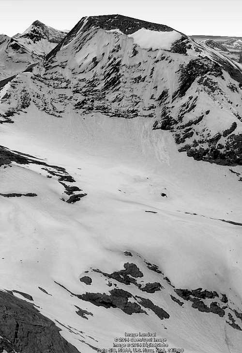
Dimensions and mass of glaciers in the Glaciers of Valtournenche Valley (Matterhorn - Monte Cervino). The valley has fifteen glaciers as follows:

Dimensioni e massa dei ghiacciai della Valtournenche (Matterhorn - Monte Cervino). La valle possiede quindici ghiacciai così ripartiti:


  • 1)   - Roisette Glacier
  • 2)   - Volfrède Glacier
  • 3)   - Col du Château des Dames Glacier
  • 4)   - Mont Blanc du Créton Glacier
  • 5)   - Des Jumeaux Glacier
  • 6)   - Mont Tabel Glacier
  • 7)   - Chérillon Glacier
  • 8)   - Leone Glacier
  • 9)   - Pic Tyndall Glacier
  • 10) - Cervino Glacier
  • 11) - Forca Glacier
  • 12) - Teòdulo Glacier
  • 13) - Valtournenche Glacier
  • 14) - Roisetta Glacier
  • 15) - Tournalin Glacier

Roisette Glacier

Roisette Glacier
Roisette Glacier


  • Features: Circus Glacier
  • Sector: Pennine Alps (Matterhorn - Monte Cervino)
  • Surrounding summits: Punta Cian 3.322m
  • Maximum altitude: 3.100m~
  • Minimum altitude: 3.000m~
  • Exposure: N-E
  • Maximum length: 300m~
  • Maximum width: 400m~
  • Maximum extension: 0,068km²~ 6,8ha~
  • Mean deep: -
  • Maximum deep: -
  • Activity: Moderate retreat
  • Mean slope: -
  • Caratteristiche: Ghiacciaio di circo
  • Settore: Alpi Pennine (Matterhorn - Monte Cervino)
  • Vette principali: Punta Cian 3.322 m
  • Quota massima: 3.100 m~
  • Quota minima: 3.000 m~
  • Esposizione: N-E
  • Lunghezza massima: 300 m~
  • Larghezza massima: 400 m~
  • Estensione massima: 0,068km²~ 6,8ha~
  • Profondità media: -
  • Profondità massima: -
  • Attività: Ritiro moderato
  • Inclinazione media: -


Volfrède Glacier

Volfrède Glacier
Volfrède Glacier


  • Features: Circus Glacier
  • Sector: Pennine Alps (Matterhorn - Monte Cervino)
  • Surrounding summits: Mont Rous 3.224m
  • Maximum altitude: 3.150m~
  • Minimum altitude: 2.880m~
  • Exposure: N-E
  • Maximum length: 650m~
  • Maximum width: 490m~
  • Maximum extension: 0,134km²~ 13,4ha~
  • Mean deep: -
  • Maximum deep: -
  • Activity: Not sure
  • Mean slope: -
  • Caratteristiche: Ghiacciaio di circo
  • Settore: Alpi Pennine (Matterhorn - Monte Cervino)
  • Vette principali: Mont Rous 3.224 m
  • Quota massima: 3.150 m~
  • Quota minima: 2.880 m~
  • Esposizione: N-E
  • Lunghezza massima: 650 m~
  • Larghezza massima: 490 m~
  • Estensione massima: 0,134 km²~ 13,4 ha~
  • Profondità media: -
  • Profondità massima: -
  • Attività: Incerta
  • Inclinazione media: -


Col du Château des Dames Glacier

Col du Château des Dames Glacier


  • Features: Uncertain
  • Sector: Pennine Alps (Matterhorn - Monte Cervino)
  • Surrounding summits: Mont Rous 3.224m
  • Maximum altitude: 3.190m~
  • Minimum altitude: 3.010m~
  • Exposure: E
  • Maximum length: 340m~
  • Maximum width: 180m~
  • Maximum extension: 0,045km²~ 4,5ha~
  • Mean deep: -
  • Maximum deep: -
  • Activity: Not sure
  • Mean slope: -
  • Caratteristiche: Incerte
  • Settore: Alpi Pennine (Matterhorn - Monte Cervino)
  • Vette principali: Mont Rous 3.224 m
  • Quota massima: 3.190 m~
  • Quota minima: 3.010 m~
  • Esposizione: E
  • Lunghezza massima: 340 m~
  • Larghezza massima: 180 m~
  • Estensione massima: 0,045 km²~ 4,5 ha~
  • Profondità media: -
  • Profondità massima: -
  • Attività: Incerta
  • Inclinazione media: -


Mont Blanc du Créton Glacier

Mont Blanc du Créton Glacier


  • Features: Uncertain
  • Sector: Pennine Alps (Matterhorn - Monte Cervino)
  • Surrounding summits: Mont Blanc du Créton 3.406m
  • Maximum altitude: 3.210m~
  • Minimum altitude: 3.090m~
  • Exposure: E
  • Maximum length: 220m~
  • Maximum width: 320m~
  • Maximum extension: 0,043km²~ 4,3ha~
  • Mean deep: -
  • Maximum deep: -
  • Activity: Not sure
  • Mean slope: -
  • Caratteristiche: Incerte
  • Settore: Alpi Pennine (Matterhorn - Monte Cervino)
  • Vette principali: Mont Blanc du Créton 3.406 m
  • Quota massima: 3.210 m~
  • Quota minima: 3.090 m~
  • Esposizione: E
  • Lunghezza massima: 220 m~
  • Larghezza massima: 320 m~
  • Estensione massima: 0,043km²~ 4,3ha~
  • Profondità media: -
  • Profondità massima: -
  • Attività: Incerta
  • Inclinazione media: -


Des Jumeaux Glacier

Des Jumeaux Glacier
Des Jumeaux Glacier


  • Features: Uncertain
  • Sector: Pennine Alps (Matterhorn - Monte Cervino)
  • Surrounding summits: Les Jumeaux 3.872m
  • Maximum altitude: 2.790m~
  • Minimum altitude: 2.650m~
  • Exposure: S-E
  • Maximum length: 240m~
  • Maximum width: 190m~
  • Maximum extension: 0,017km²~ 1,7ha~
  • Mean deep: -
  • Maximum deep: -
  • Activity: Not sure
  • Mean slope: -
  • Caratteristiche: Incerte
  • Settore: Alpi Pennine (Matterhorn - Monte Cervino)
  • Vette principali: Les Jumeaux 3.872 m
  • Quota massima: 2.790 m~
  • Quota minima: 2.650 m~
  • Esposizione: S-E
  • Lunghezza massima: 240 m~
  • Larghezza massima: 190 m~
  • Estensione massima: 0,017km²~ 1,7ha~
  • Profondità media: -
  • Profondità massima: -
  • Attività: Incerta
  • Inclinazione media: -


Mont Tabel Glacier

Mont Tabel Glacier
Mont Tabel Glacier


  • Features: Circus glacier and seracs
  • Sector: Pennine Alps (Matterhorn - Monte Cervino)
  • Surrounding summits: Punta Margherita 3.905m, Cresta Albertini 3.575m
  • Maximum altitude: 3.620m~
  • Minimum altitude: 2.610m~
  • Exposure: S
  • Maximum length: 1.990m~
  • Maximum width: 820m~
  • Maximum extension: 0,82 km²~ 82ha~
  • Mean deep: 25m~*
  • Maximum deep: 35/45m~**
  • Activity: Moderate advanced
  • Mean slope: -
  • Caratteristiche: Ghiacciaio di circo seraccato
  • Settore: Alpi Pennine (Matterhorn - Monte Cervino)
  • Vette principali: Punta Margherita 3.905 m, Cresta Albertini 3.575 m
  • Quota massima: 3.620 m~
  • Quota minima: 2.610 m~
  • Esposizione: S
  • Lunghezza massima: 1.990 m~
  • Larghezza massima: 820 m~
  • Estensione massima: 0,82 km²~ 82ha~
  • Profondità media: 25 m~*
  • Profondità massima: 35/45 m~**
  • Attività: Moderata avanzata
  • Inclinazione media: -


Chérillon Glacier

Chérillon Glacier
Chérillon Glacier


  • Features: Basin
  • Sector: Pennine Alps (Matterhorn - Monte Cervino)
  • Surrounding summits: Punta Carrel 3.918m, Punta Maria Cristina 3.708m, Cresta Albertini 3.575m
  • Maximum altitude: 3.250m~
  • Minimum altitude: 2.790m~
  • Exposure: S
  • Maximum length: 1.900m~
  • Maximum width: 1.160m~
  • Maximum extension: 0,82 km²~ 82ha~
  • Mean deep: 20m~*
  • Maximum deep: 25/35m~**
  • Activity: Moderate retreat
  • Mean slope: -
  • Caratteristiche: Bacino
  • Settore: Alpi Pennine (Matterhorn - Monte Cervino)
  • Vette principali: Punta Carrel 3.918 m, Punta Maria Cristina 3.708 m, Cresta Albertini 3.575 m
  • Quota massima: 3.250 m~
  • Quota minima: 2.790 m~
  • Esposizione: S
  • Lunghezza massima: 1.900 m~
  • Larghezza massima: 1.160 m~
  • Estensione massima: 0,82 km²~ 82ha~
  • Profondità media: 20 m~*
  • Profondità massima: 25/35 m~**
  • Attività: Ritiro moderato
  • Inclinazione media: -


Leone Glacier

Leone Glacier
Leone Glacier


  • Features: Circus Glacier
  • Sector: Pennine Alps (Matterhorn - Monte Cervino)
  • Surrounding summits: Testa del Leone 3.715m
  • Maximum altitude: 3.200m~
  • Minimum altitude: 2.980m~
  • Exposure: S
  • Maximum length: 440m~
  • Maximum width: 450m~
  • Maximum extension: 0,08km²~ 8ha~
  • Mean deep: -
  • Maximum deep: -
  • Activity: Not sure
  • Mean slope: -
  • Caratteristiche: Ghiacciaio di circo
  • Settore: Alpi Pennine (Matterhorn - Monte Cervino)
  • Vette principali: Testa del Leone 3.715 m
  • Quota massima: 3.200 m~
  • Quota minima: 2.980 m~
  • Esposizione: S
  • Lunghezza massima: 440 m~
  • Larghezza massima: 450 m~
  • Estensione massima: 0,08km²~ 8ha~
  • Profondità media: -
  • Profondità massima: -
  • Attività: Incerta
  • Inclinazione media: -


Pic Tyndall Glacier

Pic Tyndall Glacier
Pic Tyndall Glacier


  • Features: Circus Glacier
  • Sector: Pennine Alps (Matterhorn - Monte Cervino)
  • Surrounding summits: Pic Tyndall 4.257 m
  • Maximum altitude: 3.480m~
  • Minimum altitude: 3.020m~
  • Exposure: S
  • Maximum length: 600m~
  • Maximum width: 410m~
  • Maximum extension: 0,143km²~ 14,3ha~
  • Mean deep: -
  • Maximum deep: -
  • Activity: Not sure
  • Mean slope: -
  • Caratteristiche: Ghiacciaio di circo
  • Settore: Alpi Pennine (Matterhorn - Monte Cervino)
  • Vette principali: Pic Tyndall 4.257 m
  • Quota massima: 3.480 m~
  • Quota minima: 3.020 m~
  • Esposizione: S
  • Lunghezza massima: 600 m~
  • Larghezza massima: 410 m~
  • Estensione massima: 0,143km²~ 14,3ha~
  • Profondità media: -
  • Profondità massima: -
  • Attività: Incerta
  • Inclinazione media: -


Cervino Glacier

Cervino Glacier
Cervino Glacier


  • Features: Basin
  • Sector: Pennine Alps (Matterhorn - Monte Cervino)
  • Surrounding summits: Matterhorn (Monte Cervino) 4.478m
  • Maximum altitude: 3.230m~
  • Minimum altitude: 2.850m~
  • Exposure: S
  • Maximum length: 1.200m~
  • Maximum width: 800m~
  • Maximum extension: 0,45km²~ 45ha~
  • Mean deep: -
  • Maximum deep: -
  • Activity: Not sure
  • Mean slope: -
  • Caratteristiche: Bacino
  • Settore: Alpi Pennine (Matterhorn - Monte Cervino)
  • Vette principali: Matterhorn (Monte Cervino) 4.478 m
  • Quota massima: 3.230 m~
  • Quota minima: 2.850 m~
  • Esposizione: S
  • Lunghezza massima: 1.200 m~
  • Larghezza massima: 800 m~
  • Estensione massima: 0,45km²~ 45ha~
  • Profondità media: -
  • Profondità massima: -
  • Attività: Incerta
  • Inclinazione media: -


Forca Glacier

Forca Glacier
Forca Glacier


  • Features: Uncertain
  • Sector: Pennine Alps (Matterhorn - Monte Cervino)
  • Surrounding summits: Testa di Furggen 3.492m
  • Maximum altitude: 3.300m~
  • Minimum altitude: 2.810m~
  • Exposure: O
  • Maximum length: 560m~
  • Maximum width: 330m~
  • Maximum extension: 0,134km²~ 13,4ha~
  • Mean deep: -
  • Maximum deep: -
  • Activity: Not sure
  • Mean slope: -
  • Caratteristiche: Incerte
  • Settore: Alpi Pennine (Matterhorn - Monte Cervino)
  • Vette principali: Testa di Furggen 3.492 m
  • Quota massima: 3.300 m~
  • Quota minima: 2.810 m~
  • Esposizione: O
  • Lunghezza massima: 560 m~
  • Larghezza massima: 330 m~
  • Estensione massima: 0,134km²~ 13,4ha~
  • Profondità media: -
  • Profondità massima: -
  • Attività: Incerta
  • Inclinazione media: -


Teòdulo Glacier

Teòdulo Glacier
Teòdulo Glacier


  • Features: Circus glacier
  • Sector: Pennine Alps (Matterhorn - Monte Cervino)
  • Surrounding summits: Testa Grigia 3.480m
  • Maximum altitude: 3.360m~
  • Minimum altitude: 3.000m~
  • Exposure: O
  • Maximum length: 550m~
  • Maximum width: 650m~
  • Maximum extension: 0,26km²~ 26ha~
  • Mean deep: 20m~*
  • Maximum deep: 25/30m~**
  • Activity: Moderate retreat
  • Mean slope: -
  • Caratteristiche: Ghiacciaio di circo
  • Settore: Alpi Pennine (Matterhorn - Monte Cervino)
  • Vette principali: Testa Grigia 3.480 m
  • Quota massima: 3.360 m~
  • Quota minima: 3.000 m~
  • Esposizione: O
  • Lunghezza massima: 550 m~
  • Larghezza massima: 650 m~
  • Estensione massima: 0,26km²~ 26ha~
  • Profondità media: 20 m~*
  • Profondità massima: 25/30 m~**
  • Attività: Ritiro moderato
  • Inclinazione media: -


Valtournenche Glacier

Valtournenche Glacier


  • Features: Uncertain
  • Sector: Pennine Alps (Matterhorn - Monte Cervino)
  • Surrounding summits: Testa Grigia 3.480m
  • Maximum altitude: 3.460m~
  • Minimum altitude: 3.040m~
  • Exposure: S-O
  • Maximum length: 1.250m~
  • Maximum width: 950m~
  • Maximum extension: 0,968km²~ 96,8ha~
  • Mean deep: 20m~*
  • Maximum deep: 25/35m~**
  • Activity: Not sure
  • Mean slope: -
  • Caratteristiche: Incerte
  • Settore: Alpi Pennine (Matterhorn - Monte Cervino)
  • Vette principali: Testa Grigia 3.480 m
  • Quota massima: 3.460 m~
  • Quota minima: 3.040 m~
  • Esposizione: S-O
  • Lunghezza massima: 1.250 m~
  • Larghezza massima: 950 m~
  • Estensione massima: 0,968km²~ 96,8ha~
  • Profondità media: 20 m~*
  • Profondità massima: 25/35 m~**
  • Attività: Incerta
  • Inclinazione media: -


Roisetta Glacier

Roisetta Glacier
Roisetta Glacier


  • Features: Circus glacier
  • Sector: Pennine Alps (Matterhorn - Monte Cervino)
  • Surrounding summits: Monte Roisetta 3.334m
  • Maximum altitude: 3.300m~
  • Minimum altitude: 3.200m~
  • Exposure: N-O
  • Maximum length: 250m~
  • Maximum width: 140m~
  • Maximum extension: 0,02km²~ 1,95ha~
  • Mean deep: -
  • Maximum deep: -
  • Activity: Not sure
  • Mean slope: -
  • Caratteristiche: Ghiacciaio di circo
  • Settore: Alpi Pennine (Matterhorn - Monte Cervino)
  • Vette principali: Monte Roisetta 3.334 m
  • Quota massima: 3.300 m~
  • Quota minima: 3.200 m~
  • Esposizione: N-O
  • Lunghezza massima: 250 m~
  • Larghezza massima: 140 m~
  • Estensione massima: 0,02km²~ 1,95ha~
  • Profondità media: -
  • Profondità massima: -
  • Attività: Incerta
  • Inclinazione media: -


Tournalin Glacier

Tournalin Glacier
Tournalin Glacier


  • Features: Circus glacier
  • Sector: Pennine Alps (Matterhorn - Monte Cervino)
  • Surrounding summits: Grand Tournalin 3.379m
  • Maximum altitude: 3.070m~
  • Minimum altitude: 3.000m~
  • Exposure: N-O
  • Maximum length: 150m~
  • Maximum width: 400m~
  • Maximum extension: 0,039km²~ 3,9ha~
  • Mean deep: -
  • Maximum deep: -
  • Activity: Not sure
  • Mean slope: -
  • Caratteristiche: Ghiacciaio di circo
  • Settore: Alpi Pennine (Matterhorn - Monte Cervino)
  • Vette principali: Grand Tournalin 3.379 m
  • Quota massima: 3.070 m~
  • Quota minima: 3.000 m~
  • Esposizione: N-O
  • Lunghezza massima: 150 m~
  • Larghezza massima: 400 m~
  • Estensione massima: 0,039km²~ 3,9ha~
  • Profondità media: -
  • Profondità massima: -
  • Attività: Incerta
  • Inclinazione media: -


*The datum is not very sure
**Not safe datum
 
*Dato poco sicuro
**Dato non sicuro

Essential BOOKS

  • "Le Pays de la Doire et son Peuple" di Augusta Vittoria Cerutti, Musumeci Editeur, Juin 1995.

External Links

Acknowledgements

I am very grateful to my friend Osvaldo Cardellina for the text and the English translation.