
-
 6337 Hits
-
 81.84% Score
-
 14 Votes
|
|
Mountain/Rock |
|---|---|
|
|
46.64582°N / 10.51742°E |
|
|
Hiking |
|
|
Spring, Summer, Fall |
|
|
7858 ft / 2395 m |
|
|
Overview
 Glurnser Köpfl, Plaschweller, Piz Chavalatsch, Piz Umbrail Glurnser Köpfl, Plaschweller, Piz Chavalatsch, Piz Umbrail |
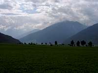
The northernmost subgroup of the Ortler / Cevedale Group is a long stretched ridge, the so-called Fallatschkamm. The Italian name is unknown to me but a literal translation would be Cresta di Valazza. The ridge is named by a mountain pass in its centre, Fallatschjoch / Passo di Valazza, overlooked by a knobbly summit, Fallatschkopf / Cima di Valazza. The ridge stretches from Stilfser Joch / Passo di Stellvio towards the mouth of Münstertal / Val Müstair, where it joins Vinschgau / Val Venosta. At the intersection of these two valleys the medevial town of Glurns / Glorenza can be found, still completely surrounded by its old city wall. And 1500m above the town you will find the lookout summit of Glurnser Köpfl / Monte di Glorenza.
The name of the mountain already indicates its shape and significance - Köpfl stands for little Kopf and thus most likely would be translated as little butte. Though almost 2400m high, the mountain barelly makes it across the timberline and compared with its neighbours, many of which pass the 3000m mark, Glurnser Köpfl / Monte di Glorenza can be considered a dwarf. Still the mountain is perfectly located to be a first rate lookout spot. As mentioned above, at its northern base Val Müstair joins the broad Vinschgau Valley, which itself follows a 90° bend to the north at the eastern base of our mountain. Thus, the terrain is open in almost all directions and the three neighbouring groups are on full display: The Ortler Group in the south and south-east, the Sesvenna Group in the north-west and the Ötztal Alps in the north-east.
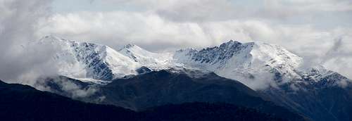
 Glurnser Köpfl Glurnser Köpfl | 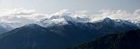 Fallatschkamm Fallatschkamm |  Reschensee Reschensee |
The summit of Glurnser Köpfl is round-topped and connects to its direct neighbours on the Fallatschkamm ridge via a broad plateau, which contains two other summits: Totenkopf / Dosso dei Morti (2390m) and Plaschweller / Monte Plagabella (2534m). They can be either reached by a long hike from Glurns / Glorenza, which scales all the 1500m or from Lichtenberger Höfe / Malghe di Montechiaro, a set of farm buildings already high up on the east slopes of the mountain. Starting at the latter trailhead reduces the elevation gain to some 800m - 1000m and is quite populr in case the higher summits of the area are covered in clouds.
Getting There
 Glurnser Köpfl / Monte di Glorenza above Val Müstair
The two trailheads at Glurns / Glorenza and Lichtenberg / Montechiaro are connected by a country road, SP50. From Lichtenberg, a narrow mountain road leads to Lichtenberge Höfe / Malghe di Montechiaro.
From Austria
Take B180 from Landeck, which at the border turns into SS40. At Mals turn onto SP85 to Glurns.
From Italy
Take SS38 from Bozen / Bolzano and Meran / Merano to Spondinig / Spondigna. Here switch to SS40 to Schluderns / Sluderno where you switch to SS41 to Glurns / Glorenza.
From Switzerland
Take B28 across Ofenpass / Pass dal Fuorn and through Münstertal / Val Müstair. At the border it turns into SS41 to Glurns / Glorenza.
Red Tape
 Cascading creek seen during the ascent to Glurnser Köpfl
Like the rest of the Ortler / Cevedale Group, Fallatschkamm is part of a national park, Nationalpark Stilfserjoch / Parco Nationale dello Stelvio. You can find information about the park on the official site
Accommodation
- Vinschgau / Val Venosta Accommodation
- Reschenpass / Passo di Resia Accommodation
- Val Müstair / Münstertal Accommodation
Weather Conditions
 Faraway view to the clouded Ötztal Alps
Maps & Books
- Vinschgau / Val Venosta
Kompass Map WK52
1:50000
ISBN: 978-3-85491-058-9
- Alta Val Venosta / Vinschgauer Oberland
Tabacco Map 43
1:25000
Books
- Vinschgau
Rother Wanderführer
Rother Verlag
ISBN: 978-3-7633-4204-1
- Vinschgau / Ortlergruppe
Kompass Wanderbuch 950
Kompass Verlag
ISBN: 3-87051-404-3