
-
 5667 Hits
-
 85.36% Score
-
 20 Votes
|
|
Area/Range |
|---|---|
|
|
46.59558°N / 10.49304°E |
|
|
Hiking, Scrambling, Skiing |
|
|
Summer, Fall, Winter |
|
|
9928 ft / 3026 m |
|
|
1 - Overview
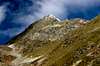
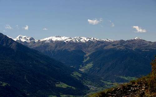 Fallatschkamm / Cresta Vallazza as seen from Naturnser Höhenweg Fallatschkamm / Cresta Vallazza as seen from Naturnser Höhenweg |
Falatschkamm - I took the liberty of translating the German name into Italian though most likely it isn't used this way - is the northernmost subgroup of the Ortler / Ortles Group in the eastern Alps. It is also one of the smallest and lowest subgroups where only two of the two dozen summits exceed 3000m. The subgroup consists of two ridges - a main ridge, which gave rise to the name, and a side ridge with a mere two summits to the west. Both ridges run south to north with the highest mountains in the south. To the north the subgroup ends high above the confluence of Münstertal / Val Müstair into Vinschgau / Val Venosta
. To the south it ends in Stilfser Joch / Passo dello Stelvio, which separates Trafoier Tal / Val di Trafoi from Valle di Braulio. The western boundary of the group is Val Muraunza, which heads up from Münster / Müstair to Umbrailpass / Giogo di Santa Maria.
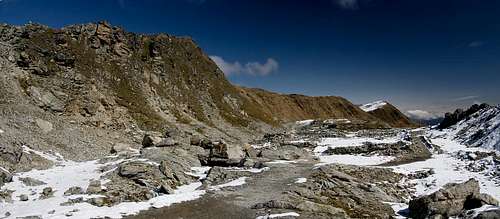
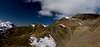
The mountains of Fallatschkamm / Cresta Vallazza are made up from Gneiss rock, much of which has withered away. Thus the summits don't stand out much from the remainder of the ridge. Thanks to its posiition high above the valleay and thanks to the fact that the nearby Umbrail and Sesvenna Groups are not much higher, all of the mountains of Fallatschkamm / Cresta Vallazza are excellent viewpoints. The most popular summits are Glurnser Köpfl / Monte di Glorenza in the very north and Rötlspitz / Punta Rosa. Even though the former is the lowest mountain of the group it stands out 1500m from its surroundings. The latter, while being the highest mountain of the group can very easily be reached from Stlifser Joch / Passo dello Stelvio by a 300m hike. Also worth mentioning is the panoramic Trafoier Höhenweg which runs from Furkelhütte / Rifugio Furcola to Stilfser Joch / Passo ddello Stelvio and offers wonderful views of the central Ortler / Ortles Group.
 |  |  |
Fallatschkamm / Cresta Vallazza always used to be a border ridge, which up to WW I was the border between Austria and Switzerland and which after the Peace of St. Germain turned into the border between Italy and Switzerland. Also, it is the border between three languages. On the Swiss Grisons side Rhaetoromanic is spoken, on the Italian side we have Italian in Lombardia (in the south-west of the group) and German in South Tirol / Alto Adige. Therefore the southernmost summit of the range, where the three regions meet, in German is named Dreisprachenspitze (Three Languages Peak).
 Ruins of Austrian WW I barracks on Dreisprachenspitze
During WW I this peak turned became of high strategic importance. Two of the countries, Austria and Italy, were fighting the war while Switzerland remained neutral. In the region, the Swiss border turns south and forms a wedge shaped area, which at the time separated Italy from Austria. Both war faring countries seeked proximity with their neutral neighbour, often placing observation points side by side with their Swiss counterparts. Today you can still find lots of places in the area which date back to the big war. On Dreisprachenspitze a whole Austrian batallion had their barracks, which now looks like a ghost town dating back to old times
Sometimes Fallatschkamm / Cresta Vallazza is also referred to as Costainaskamm / Cresta Costainas or Chavalatschkamm / Cresta Cavallaccio.
2 - Fallatschkamm / Cresta Vallazza on SP
  |
- Fallatschkamm / Cresta Vallazza
3 - The Summits
|
The following listing follows the Alpenvereinsführer (German Alpine Club guidebook , see list of books below). Where possible, I listed the German, Italian or Rhaetian names. As for the elevations, there have been at least two measurements for the whole range. Here I stick with the younger Italian ones.
- Glurnser Köpfl / Monte di Glorenza (2401m)
![]()
- Totenkopf / Dosso dei Morti (2390m)
- Plaschweller / Monte Plagabella (2534m)
![]()
- Piz Chavalatsch / Monte Cavallaccio (2764m)
![]()
- Munwarther / Monte della Guardia (2621m)
![]()
- Piz Sielva (2855m)
![]()
- Tradakopf (2578m)
- Schafberg / Piz Mischuns (2935m)
![]()
- Piz Chalderas (2794m)
- Prasura (2565m)
- Pandakopf (2515m)
- Fallatschkopf / Cima di Vallazza (2905m)
![]()
- Furkelspitze / Pizzo della Forcola (3004m)
![]()
- Tartscher Kopf / Monte di Tarres (2963m)
![]()
- Kleiner Tartscher Kopf / Cima Piccola di Tarres (2935m)
![]()
- Korspitz / Col di Quaira (2933m)
![]()
- Rötlspitz / Punta Rossa (3026m)
![]()
- Dreisprachenspitze / Cima Garibaldi (2843m)
![]()
- Weißer Knott / Rocca Bianca (2451m)
3.2 - West Ridge
- Piz Stabels (2955m)
- Piz Val Gronda (2880m)
3.1 - Main Ridge


4 - Getting There
 |
Fallatschkamm / Cresta Vallazza is surrounded by mountain roads. Still its accessibility is rather low. There are only few trailheads from which elevation differences are manageable: Stilfser Joch / Passo dello Stelvio at 2758m has the shortest routes. Furkelhütte / Rifugio Forcola at 2153m is reachable by chair lift. Alp Prasura at 2213 can be reached from the Umbrailpass Road and the pastures of Lichtenberger Höfe is accessible from Vinschgau / Val Venosta. Still, elevation differences of more than 1000m are the rule.
From South Tyrol / Alto Adige
- Take SS38 from Bozen / Bolzano through Meran / Merano and Vinschgau / Val Venosta.
- At Spondinig / Spondigna the road turns off in direction of Stilfser Joch Passo di Stelvio.
- Alternatively, at Spondinig / Spondigna turn onto SS40 to Schluderns / Sluderno.
- Here turn onto SS41 which leads into Switzerland.
- Called B28 there the road leads to Santa Maria, where the road to Umbrailpass turns off south (open from 6 a.m. through 8 p.m.).
From Lombardia
- Take SS38 direction Stilfser Joch / Passo di Stelvio.
- Shortly before you reach Stilfser Joch / Passo di Stelvio the Umbrailpass road turns off left (north) for the western parts of the group.
From Graubünden
- Take B28 across Ofenpass / Pass dal Fuorn until you reach Santa Maria.
- Here turn south onto the road to Umbrailpass (open 6 a.m. through 8 p.m.).
- Alternatively stay on the road towards Glurns / Glorenza and Prad / Prato
From Austria
- From Landeck take B180 across Reschenpass / Passo di Resia into South Tyrol / Alto Adige.
- The road, SS40 in Italy, takes you to Mals / Malles Venosta.
- Here, turn onto a side road through Laatsch / Laudes, which heads for Switzerland, joining SS41 several kilometres in front of the border.
- At Santa Maria, the road to Umbrailpass (open 6 a.m. - 8 p.m.) turns off.
- Alternatively take the road towards Glurns / Glorenza and Prad / Prato
5 - Accommodation
There is only one mountain hut in the group, Furkelhütte / Rifugio Forcola. It is the endpoint of a chair lift from Trafoi and serves the skki area of Stilfs / Stelvio.6 - Red Tape
The Fallatschkamm / Cresta Vallazza Main Ridge is the border between Switzerland and Italy. Though both countries ratified the Schengen treaties it is always a good idea to keep an ID handy. Also, the Italian part of the group belongs to Nationalpark Stilfser Joch / Parco Nazionale dello Stelvio. See the following link for more information:7 - Weather Conditions
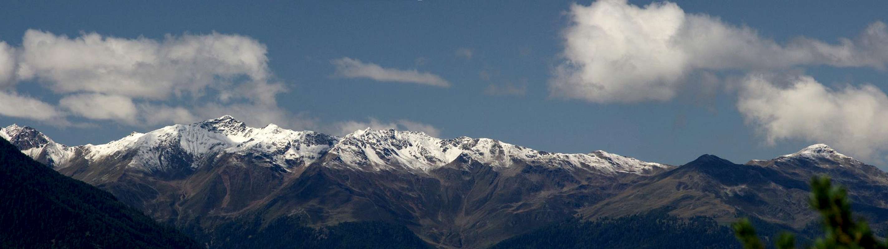
 Glurnser Köpfl, Plaschweller, Piz Chavalatsch
8 - Maps & Books
8.1 - Maps
- Nationalpark Stilfserjoch / Parco Nazionale dello Stelvio
Kompass Map WK072
1:50000
ISBN: 3-85491-391-5
- Vinschgau / Val Venosta
Kompass Map WK52
1:50000
ISBN: 978-3-85491-058-9
- Val Venosta - Vinschgau - Sesvenna
Tabacco Map 044
1:25000
ISBN: 978-8883150609
8.2 - Books
- Vinschgau
Rother Wanderführer
Rother Verlag
ISBN: 978-3-7633-4204-1
- Vinschgau / Ortlergruppe
Kompass Wanderbuch 950
Kompass Verlag
ISBN: 3-87051-404-3 - Unterengadin
R. and S. Weiss
Rother Verlag
ISBN: 3-7633-4043-2
- Ortleralpen
P. Holl
Alpenvereinsführer
Rother Verlag
ISBN: 3-7633-1313-3