
-
 5279 Hits
-
 80.49% Score
-
 12 Votes
|
|
Mountain/Rock |
|---|---|
|
|
46.63518°N / 10.50790°E |
|
|
Hiking, Skiing |
|
|
Summer, Fall, Winter |
|
|
8314 ft / 2534 m |
|
|
Overview
 Plaschweller main summit Plaschweller main summit |
In the north of the Ortler / Cevedale Group the long Fallatschkamm / Cresta di Valazza leads from Stilfser Joch / Passo Dello Stelvio towards the ancient city of Glurns / Glorenza ending at Glurnser Köpfl / Monte di Glorenza. It is one of the lower subgroups of the range, consisting of a single northbound ridge with a short additional side ridge near Stilfser Joch. Still only three parts of the ridge can be reached by hikers, the southern part near Rötelspitz / Punta Rosa, the central part near Piz Minschuns / Schafberg and the northern part between Piz Chavatatsch / Monte Cavallaccio and Glurnser Köpfl / Monte di Glorenza. The central mountain of this latter section is Plaschweller / Monte Plagabella.
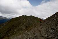
 Beneath the Plaschweller summit ridge
Unlike its neighbour Glurnser Köpfl / Monte di Glorenza, Plaschweller / Monte Plagabella is more than just a round-topped mountain with a good view towards Vinschgau / Val Venosta and Münstertal / Val Müstair. Its twin summits are connected by a rocky ridge, on which you experience a moderate amount of exposure already. The mountain is located in the triangle, which is formed by the Vinscgau and Münstertal Valleys and thus often is exposed to high winds which hit it unimpeded from either north, east or west.
 |  |  |
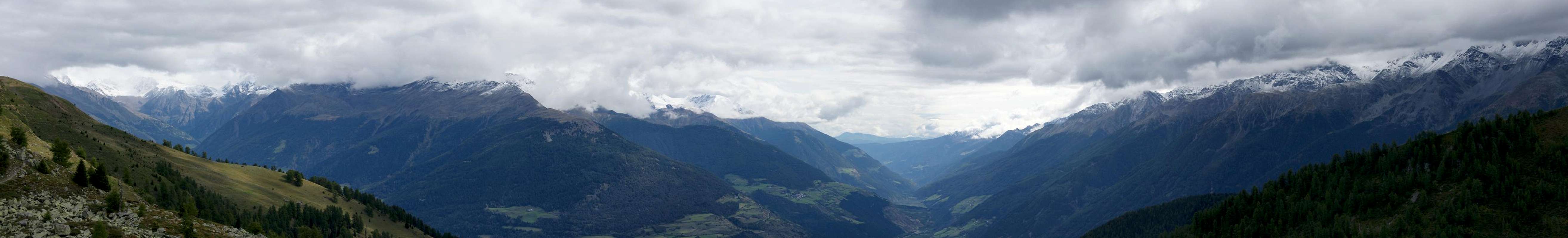
There are three possible trailheads, one at Taufers / Tubre, one at Glurns / Glorenza and one at Lichtenberger Höfe / Malghe di Montechiaro, a small hamlet at 1500m on a balcony above the Vinschgau Valley. The two former trailheads scale between 1300m and 1600m in elevation so that the mountain is usually climbed from Lichtenberger Höfe / Malghe di Montechiaro. Often the ascent is connected with a visit of Glurnser Köpfl / Monte di Glorenza which is separated from Plaschweller by a high plateau only.
Trailhead Panorama
  |
Getting There
 Plaschweller as seen from Piz Dora
The two trailheads at Glurns / Glorenza and Lichtenberg / Montechiaro are connected by a country road, SP50. From Lichtenberg, a narrow mountain road leads to Lichtenberger Höfe / Malghe di Montechiaro.
From Austria
Take B180 from Landeck, which at the border turns into SS40. At Mals turn onto SP85 to Glurns.
From Italy
Take SS38 from Bozen / Bolzano and Meran / Merano to Spondinig / Spondigna. Here switch to SS40 to Schluderns / Sluderno where you switch to SS41 to Glurns / Glorenza.
From Switzerland
Take B28 across Ofenpass / Pass dal Fuorn and through Münstertal / Val Müstair. At the border it turns into SS41 to Glurns / Glorenza.
Red Tape
Like the rest of the Ortler / Cevedale Group, Fallatschkamm is part of a national park, Nationalpark Stilfserjoch / Parco Nationale dello Stelvio. You can find information about the park on the official siteAccommodation
- Vinschgau / Val Venosta Accommodation
- Reschenpass / Passo di Resia Accommodation
- Val Müstair / Münstertal Accommodation
Weather Conditions
Maps & Books
- Vinschgau / Val Venosta
Kompass Map WK52
1:50000
ISBN: 978-3-85491-058-9
- Alta Val Venosta / Vinschgauer Oberland
Tabacco Map 43
1:25000
Books
- Vinschgau
Rother Wanderführer
Rother Verlag
ISBN: 978-3-7633-4204-1
- Vinschgau / Ortlergruppe
Kompass Wanderbuch 950
Kompass Verlag
ISBN: 3-87051-404-3