
|
|
Route |
|---|---|
|
|
52.64256°N / 4.00941°W |
|
|
Trad Climbing |
|
|
Spring, Summer, Fall, Winter |
|
|
Less than two hours |
|
|
Moderate (5.1 - 5.2 YDS) |
|
|
2 |
|
|
Overview
Even though Snowdonia's feral goats have been known to accomplish feats that would make even the hardened mountaineer think twice about embarking on, with a name like Goat Walk, you probably wouldn't expect this route to conjure up too many difficulties; and you'd be right. Graded at Moderate, this is the easiest route on Craig yr Aderyn and one of its most accessible too. It takes a more or less direct line up the broken and slightly discontinuous slabs and ribs of the crag's West Face in two neat pitches. It's a great line to warm up on before moving on to harder endevours, or an ideal introduction to pitched climbing for multi-pitch virgins. It goes without saying that its setting is nothing short of sublime, for in Wales, there are fewer valleys more picturesquely immaculate as the Dysynni. FA: Unknown. |
Getting There


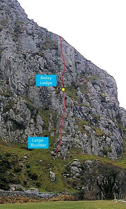 Goat Walk Most visitors to Craig yr Aderyn will approach the rock from the east, if you have to approach from the west, then you clearly know the area well enough already, and therefore don’t need a section such as this to help you get there. So, if you are coming from the east, you need to turn off the A470 at the Cross Foxes Inn junction (SH 766 167), and drive south along the A487 for some 6km to the junction for the B4405 near the Minffordd Hotel (SH 732 114). For those familiar with the area, this is the same turning as you would take for the car park on the southern side of Cadair Idris where the Minffordd Path starts. Drive along the B4405 as far as Abergynolwyn (SH 677 069). In the centre of the village there is a crossroads, turn right here and drive north up a narrow unclassified road to another set of crossroads marked by a public phone box (SH 662 079). Turn left here and drive west along another unclassified road. After a around a kilometre and a half the road reaches Craig yr Aderyn and passes along the base of its north face, There are various lay-bys along the road where parking is available. Park under The Bastion face and walk along the wall a short distance to the crag's West Face. Locate a huge block beneath an obvious rib and start your climb there. |
Route Description
Pitch 1 (21m): Ascend the slabby edge of the obvious rib to a grassy ledge on the left. Belay from here harnessing a handy block above you. Pitch 2 (21m): Climb the wall directly behind the belay to a ledge. Move left and climb the edge of a smooth wall. Above this there is apparently a spike belay, I could not find it. Belay where you can. |
Essential Gear
It's an easy route so a moderate rack of nuts and hexes will be more than enough. A singe 50 metre rope will be fine as the route meanders very little and there should be no rope drag. Loose rock may be encountered so a helmet is probably a good idea. |

One of the best views in Snowdonia. The mountain in the centre of the photo is Cadair Idris (Photo by Nanuls)
Maps
Guidebooks
|

External Links
 Craig yr Aderyn from the opposite hills © Copyright Chris Denny and licensed for reuse under this Creative Commons Licence Craig yr Aderyn from the opposite hills © Copyright Chris Denny and licensed for reuse under this Creative Commons Licence A great place to spend a day (Photo by Nanuls) A great place to spend a day (Photo by Nanuls)Government Bodies and Official Organisations Snowdonia National Park Authority Association of National Park Authorities Royal Commission on Ancient & Historical Monuments in Wales Hiking, Climbing and Mountaineering Organisations and Companies British Mountaineering Council Plas y Brenin National Mountain Centre Weather Tourist Information North Wales Tourism Partnership Local Information from Gwynedd.com Local Information from Snowdonia Wales Net Travel Welsh Public Transport Information Accommodation Youth Hostel Association in Wales Maps and Guidebooks Cordee Travel and Adventure Sports Bookshop Wildlife and Conservation |