
|
|
Canyon |
|---|---|
|
|
38.82527°N / 110.5695°W |
|
|
Canyoneering |
|
|
Spring, Fall |
|
|
Overview
Baptist Draw is technical slot canyon located in the Sinbad Country of the San Rafael Swell. The canyon provides a great introduction to technical canyoneering. The normal route requires moderate rappeling and navigation skills but allows one to experience the beautiful narrows of the Sinbad. The route starts in Baptist Draw and drops into Upper Chute canyon through a series of 3 rappels before making a loop back to the trailhead.Getting There
Baptist Draw is fairly easily accessed from I-70 west of Green River, Utah. From Green River, take I-70 west roughly 29 miles to mile marker 131. Get off of the interstate and follow the underpass. Take the dirt road marked U24/Goblin Valley/Temple Mountain. Follow this road for about 10 miles until you come to the Red Canyon/Tan Seep junction. Take the right fork and continue for about 4 miles until you come to the Red Canyon/McCay Flat junction. Go right and continue for roughly 1 mile where you will reach the McCay Flat junction. Go left and continue for about 3.8 miles where you will come to a cattle guard across the road. 150 yards from the cattle guard a dirt track on the left leaves the maintained road. Take this unmaintained track (high clearance vehicle recommended) for 2.8 miles to an unsigned fork. Go left for about 0.6 miles. Park anyplace among the many turnouts and campsites.Route Overview
The route is fairly straight forward but requires some route finding at the beginning and end.From the parking area, walk to the northeast several yards to edge of the mesa where a moderate slope descends below you. From this vantage point you will see Teepee Rock about 1/4 mile below. Descend the slope into the valley below. There are several footpaths leading down. The route goes around the southern end of Teepee Rock and drops into Baptist Draw below its eastern slope.

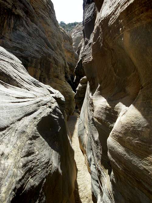
Once into the canyon bottom head downstream. The canyon is fairly wide and open at this point. As you head downstream, however, the canyon will begin narrowing pretty quickly. Soon you will find yourself able to touch both canyon walls at the same time having to squeeze through sections. This is where the best narrows of the route are found.
About 30 minutes from where you first reached the canyon bottom, you will come to the first of 3 rappels. It is a short, 15 foot rappel. There is an existing anchor, but be sure to check the webbing to make sure it looks safe. This goes for the other 2 rappels as well. You may need to add an additional sling and remove an old one. There are more great narrow sections below the first rap.
About 10 minutes from the first rappel, is the second rappel. This is an 80' rap with an awkward start. This is an intimidating rappel for beginners. This rappel is located where Baptist Draw plunges into Upper Chute Canyon.

From the bottom of the 2nd rappel, there are two options. One can take a short detour go upstream (left) and explore the narrows in Upper Chute Canyon for a bit and then return to the bottom of the 2nd rap. Or, one can just continue on the route downstream. The 3rd rappel comes quickly after entering Upper Chute Canyon.
The 3rd rappel is another short, 20' rap. People have opted to skip the rap and downclimb here, but it is not recommended. The consequences are too great and this is a very remote area. Help is a very long ways away.
Below the 3rd rap, the canyon begins to open up a bit and it becomes much deeper than in the Baptist Draw section. There are several sections below the 3rd rap that fill with water. The level can range a great deal from waist high to completely dry. The water is often filthy and smells horrible. It can also be freezing cold despite very hot air temperatures.
Roughly 1 hour from the second rappel, Upper Chute Canyon opens up. There is a drainage leading off to the right hand side (facing down stream) with a sandy cattle trail. This is Fault Line Canyon where you will leave Upper Chute canyon and begin your return. Follow Fault Line Canyon for roughly 2 miles (about 1 hour). You will see a drainage to the right hand side (facing up canyon). Climb this drainage to the top of mesa and walk north to you get to its rim. You will see a fairly wide valley below. The trailhead is across this valley. Find one of several cattle paths crossing the valley and climb to the rim of the opposite mesa. The trailhead should be a little north and east of here.
It is easy to get disoriented here. There are few distinctive landmarks and much of the terrain looks similar. I strongly suggest taking a GPS and marking your car. It also helps to walk from your car to on overlook of this last valley before starting the hike. This way you will be more familiar with the area on your return and it will make the route finding easier. This is not a good place to get lost as water is hard to come by.
Red Tape
None.Camping
Several campsites are present at the parking area. Please use an existing ring if making a campfire. Camping is also allowed throughout the Sinbad Country and in many other places in the San Rafael Swell.Camping is not recommended in the canyons. Please help keep these places beautiful and primitive.
External Links
Directions from: http://climb-utah.com/SRS/baptist.htmanother good source: http://www.americansouthwest.net/slot_canyons/baptist_chute/canyons.html