

-
 12318 Hits
-
 84.82% Score
-
 19 Votes
|
|
Area/Range |
|---|---|
|
|
47.07370°N / 12.58790°E |
|
|
10604 ft / 3232 m |
|
|
Overview
Geographical classification: Eastern Alps > Hohe Tauern GROUP > Granatspitze Group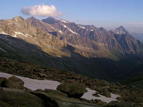 Granatspitze Group
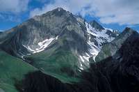
The Granatspitze Group is a narrow mountain range between the Glockner Group and Schober Group (east), and the Venediger Group (west). It is one of the less known and smallest mountains ranges in the Hohe Tauern Group. The range starts north at the Zwölferkogel (2446m) and ends almost 40 kilometers south at the Rotenkogel (2762m). The reason why this range is less familiar is probably because of the alltitude of the mountains. The highest mountain is the Muntanitz and not the Granatspitze after wich the range is named at. The Muntanitz (3,232m/10,604ft) is fairly lower than it's more known neighbours like the Grossglockner (12461 ft / 3798 m) or Grossvenediger (12015 ft / 3662 m).
The range is slightly glaciated, the most important glaciers are the Granatspitz glacier, Prägrat glacier and the Sonnblick glacier, all around the Granatspitze and Stubacher Sonnblick. The Granatspitze Group is a perfect range for people who'd like to avoid the busy mountain areas. There are few mountain huts and the route are pretty long compared to nearby mountain areas. The most famous routes is the St Pöltner Weg. It runs from the Neuer Prager hütte(Venediger Group) via the St Pöltner hütte to the Rudolfs-Hütte (Alpine center) on the Weissee. The Matreier Tal and Kalser Tal, are noted for their beautiful lakes (Hintersee, Grünsee, Weissee, Tauernmoossee) and beautiful forests.
The most important villages are Matrei in Ost-Tirol (west), Kals (east) and Mittersill and Uttendorf in Salzburg (north).
Getting there / Maps
The Granatspitze Group is located in the center of the Hohe Tauern. The range can be diveded into a few valleys: The Felber Tal, Stubachtal, Matreier Tal and Kalser Tal. Getting there depends on in which valley you want to start your activities. The two following maps should help you getting there, or please see the excellent Hohe Tauern Group page on SP.
On the map below you can get a good impression of the Granatspitze Group area. As you can see the range is pretty narrow.

Main Mountains
The following table contains all the main mountain in the Granatspitze Group. I've selected the mountains, so it is very subjective. Please help let me know if I've missed a main mountain.Some of the main mountains already have a page on SP, but not all of them. Especially the main mountains deserve a page. So if you have the knowledge you are invited to contribute.
| Mountain | Elevation | Starting Point |
|---|---|---|
| Muntanitz | 3232m / 10604ft | Sudetendeutsche Huette (2650 m) |
| Luckenkogel | 3100m / 10171ft | Landeggalm (1687m), Kalsertauern Haus (1754m) |
| Stubacher Sonnblick | 3088m / 10131ft | Rudolfshuette (2311m), Karl-Fuerst-Huette (2629m) |
| Kendlspitze | 3088m / 10131ft | Sudetendeutsche Huette (2650 m) |
| Granatspitze | 3086m / 10125ft | Rudolfshuette (2311m), Karl-Fuerst-Huette (2629m) |
| Gradoetzspitze | 3063m / 10049ft | Sudetendeutsche hut (2650m) |
| Hohe Fürleg | 2943m / 9656ft | Rudolfshuette (2311m), Karl-Fuerst-Huette (2629m) |
| Hochgasser | 2922m / 9587ft | Grünseehütte (2235m), St. Pöltner Hütte (2481m) |
| Riegelkopf | 2920m / 9580ft | Grünseehütte (2235m), St. Pöltner Hütte (2481m), Karl-Fuerst-Huette (2629m) |
| Landeggkopf | 2900m / 9514ft | Karl-Fuerst-Huette (2629m) |
| Rotenkogel | 2762m / 9062ft | Kals-Matreier-Törlhaus (2207m), Matreier cable car station (2190m) |
| Blauspitze | 2575m / 8448ft | Kals-Matreier-Törlhaus (2207m), Kalser Cable car station (2305m) |
| Zwölferkogel | 2446m / 8025 | Bräu-Hochalm (1822m), Dürrstein-Hochalm (1610m) |


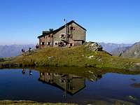
Mountain Huts
The Granatspitze Group has a low density of mountain huts, especially compared to the neighbour mountain ranges. Most of the summits can be reached in a day from one of these huts. The huts are usually closed in winter while some (mainly deeper down in the valleys) remain open for the wintertimes. The following table lists the mountain huts according to their height.| Mountain hut | Elevation | Acces | Contact |
|---|---|---|---|
| Sudetendeutsche Hütte | 2650m / 8694ft | Matrei-Glanz (1545m), Felbertauernstrasse (Stüberl: 1160m) | +43/720/347802 |
| Karl-Fürst-Hütte | 2629m / 8625ft | Felbertauernstrasse (Landecktal: 1420m) | +43/2742/310311 |
| St. Pöltner Hütte | 2481m / 8140ft | Aussergschlöss (1691m), Felbertauernstrasse (Hintersee-Duldental: 1300m) | +43/6562/6265 |
| Berghotel Rudolfshütte | 2315m / 7595ft | Enzinger Boden (1480m), Cable car to the hut! | +43/6563/8221 |
| Grünsee Hütte | 2235m / 7333ft | Matreier Tauernhaus (1512m) | +43/4875/5337 |
| Kals-Matreier-Törl-Haus | 2207m / 7241ft | Matreier cable car station (2190m), Kals (1325m), Matrei (975m), Kalser Cable car station (2305m) | +43/664/9256806 |
| Kalser Tauern Haus | 1755m / 5758ft | Kals-Tauerer (1521m | +43/664/9857090 |


Red tape
No limitations of alpine activity, though most of the group is part of the national park. Normal rules like: stay on paths, take your garbage with you, no camping, etc.See this page for more information and rules of the National Park Hohe Tauern
Maps and (Guide)books
Map 1:25 000:- Granatspitzgruppe
Alpenvereinskarte 39
- Glocknergruppe, NP Hohe Tauern
Kompass Map WK39
ISBN-10: 3854910444
- Matrei - Defereggen - Virgental
Freytag & Berndt WK 123
- Glockner-, Granatspitz-, Venedigergruppe
Willi End / Hubert Peterka
Alpenvereinsführer
Rother Verlag
ISBN: 978-3-7633-3237-3
To order Freytag & Berndt maps: www.freytagberndt.at
To order the Rother Wanderführer: www.rother.de
External Links
* Weather forecast* Avalance Bulletin
* Time Table Bus
* Time Table Train
Jurgen - Jan 20, 2009 4:11 am - Hasn't voted
Update!This page was empty for almost three years. I've adopted the page and try to full it with usefull information. Any additions or corrections? Thanks!